Sabden Brook
Sabden Brook is a small river running through Lancashire in England. It is 7.59 miles (12.21 km) long and has a catchment area of 6.84 square miles (17.723 km2).[1]
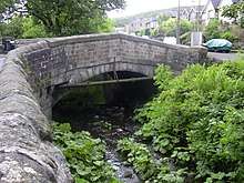
Rising just to the west of Newchurch-in-Pendle, Sabden Brook moves westward through its well-defined valley, past Sabden Hall to the village of Sabden, east of the town of Whalley. From there, the brook turns southwesterly, widening out, overlooked by Wiswell Moor and the ancient hillfort at Portfield before conjoining with the waters of the River Calder at Cock Bridge near Read.[2][3]
Sabden is believed to have been derived from Old English words sæppe denu, meaning valley of the spruce trees.[4] Brook (OE broc) is a common name for a stream, most often found in southern and central England.[5][6]
References
- "Sabden Brook". Catchment Data Explorer. Environment Agency. Retrieved 12 November 2017.
- "103" (Map). Blackburn & Burnley (C2 ed.). 1:50,000. Landranger. Ordnance Survey. 2006. ISBN 978-0-319-22829-6.
- Historic England, "Portfield hillfort (1013608)", National Heritage List for England, retrieved 12 November 2017
- Ekwall, Eilert (1922). The place-names of Lancashire. Manchester University Press. p. 78. OCLC 82106091.
- Ekwall, p8.
- Cara Giaimo, "Mapping the U.K.'s Many, Many Names for Streams", atlasobscura.com, retrieved 30 November 2017
External links
![]()
| Next confluence upstream | River Calder | Next confluence downstream |
| Hyndburn Brook (South) | Sabden Brook | - |