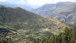
Sañayca District
Sañayca District is one of the seventeen districts of the Aymaraes Province in Peru.[1]
Sañayca | |
|---|---|
 | |
| Country | |
| Region | Apurímac |
| Province | Aymaraes |
| Founded | November 14, 1944 |
| Capital | Sañayca |
| Government | |
| • Mayor | Ivan Cortez Terrazas |
| Area | |
| • Total | 448.91 km2 (173.33 sq mi) |
| Elevation | 3,370 m (11,060 ft) |
| Population (2005 census) | |
| • Total | 1,354 |
| • Density | 3.0/km2 (7.8/sq mi) |
| Time zone | UTC-5 (PET) |
| UBIGEO | 030412 |
Geography
One of the highest peaks of the district is Hatun Wamanwiri at approximately 4,400 m (14,400 ft). Other mountains are listed below:[2]
- Aqu Q'asa
- Chawpi Urqu
- Ichhu Marka
- Ichhu Urqu
- Kirki Q'asa
- Kuntur Marka
- Kuntur Wachu
- Llulluch'a
- Llulluch'aw
- Ñawpa Llaqta
- Pichqa Pukyu
- Pilluni
- Puka Qucha
- P'unqu
- Qucha Qucha
- Qullpa
- Qura Unu
- Siwi Sirk'a
- Sullka Wamanwiri
- Waylla Qucha
- Yana Mach'ay
- Yana Urqu
Ethnic groups
The people in the district are mainly indigenous citizens of Quechua descent. Quechua is the language which the majority of the population (84.15%) learnt to speak in childhood, 15.44% of the residents started speaking using the Spanish language (2007 Peru Census).[3]
References
- (in Spanish) Instituto Nacional de Estadística e Informática. Banco de Información Digital Archived 2008-04-23 at the Wayback Machine. Retrieved April 7, 2008.
- escale.minedu.gob.pe/ UGEL map Aymaraes Province (Apurímac Region)
- inei.gob.pe Archived 2013-01-27 at the Wayback Machine INEI, Peru, Censos Nacionales 2007, Frequencias: Preguntas de Población: Idioma o lengua con el que aprendió hablar (in Spanish)
| |
|---|---|
| Abancay | |
| Andahuaylas | |
| Antabamba | |
| Aymaraes | |
| Chincheros | |
| Cotabambas | |
| Grau | |
This article is issued from Wikipedia. The text is licensed under Creative Commons - Attribution - Sharealike. Additional terms may apply for the media files.