Sætre, Møre og Romsdal
Sætre (also called Vartdal) is a village along the shore of the Vartdalsfjorden in Ørsta Municipality in Møre og Romsdal county, Norway. It is located in the Årset valley in the Vartdal district of Ørsta. The village sits along the European route E39 highway about 3.5 kilometres (2.2 mi) northeast of the village of Flåskjer and about 4 kilometres (2.5 mi) southwest of the village of Nordre Vartdal. The mountain Saudehornet is located about 7 kilometres (4.3 mi) south of the village.[3]
Sætre Vartdal | |
|---|---|
Village | |
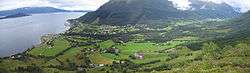 View of the village along the Vartdalsfjorden | |
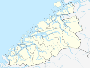 Sætre Location in Møre og Romsdal  Sætre Sætre (Norway) | |
| Coordinates: 62.3038°N 6.0934°E | |
| Country | Norway |
| Region | Western Norway |
| County | Møre og Romsdal |
| District | Sunnmøre |
| Municipality | Ørsta Municipality |
| Area | |
| • Total | 0.62 km2 (0.24 sq mi) |
| Elevation | 32 m (105 ft) |
| Population (2018)[1] | |
| • Total | 423 |
| • Density | 682/km2 (1,770/sq mi) |
| Time zone | UTC+01:00 (CET) |
| • Summer (DST) | UTC+02:00 (CEST) |
| Post Code | 6170 Vartdal |
The 0.62-square-kilometre (150-acre) village has a population (2018) of 423 and a population density of 682 inhabitants per square kilometre (1,770/sq mi).[1]
This village was the administrative centre of the former municipality of Vartdal from 1895–1964.
References
- Statistisk sentralbyrå (1 January 2018). "Urban settlements. Population and area, by municipality".
- "Sætre, Ørsta (Møre og Romsdal)". yr.no. Retrieved 2019-09-19.
- Store norske leksikon. "Sætre – i Ørsta" (in Norwegian). Retrieved 2010-09-22.
This article is issued from Wikipedia. The text is licensed under Creative Commons - Attribution - Sharealike. Additional terms may apply for the media files.