Saudehornet
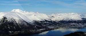
Saudehornet or Sauehornet is a mountain that is located 3 kilometres (1.9 mi) north of the village of Ørsta in the municipality of Ørsta in Møre og Romsdal county, Norway. The 1,303-metre (4,275 ft) is a very popular, though steep, destination for skiing in the Sunnmørsalpene range. It is located just north of the European route E39 highway, about 5 kilometres (3.1 mi) north of the Ørsta-Volda Airport, Hovden, and about 7 kilometres (4.3 mi) south of the village of Vartdal.[3]
Saudehornet
| Saudehornet | |
|---|---|
| Sauehornet | |
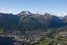
 Saudehornet (left) seen from Helgehornet. Ørsta to the right and the Ørstafjorden below. | |
| Highest point | |
| Elevation | 1,303 m (4,275 ft) [1] |
| Prominence | 825 m (2,707 ft) [1] |
| Coordinates | 62.2356°N 6.1425°E[2] |
| Geography | |
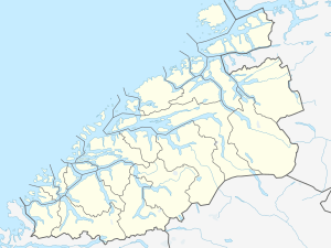 Saudehornet Location of the mountain  Saudehornet Saudehornet (Norway) | |
| Location | Møre og Romsdal, Norway |
| Parent range | Sunnmørsalpene |
| Topo map | 1119 II Volda |
See also
- List of mountains of Norway
References
- "Saudehornet". Petter Bjørstad's mountain page. Retrieved 2010-09-22.
- "Saudehornet, Ørsta (Møre og Romsdal)" (in Norwegian). yr.no. Retrieved 2019-09-15.
- Store norske leksikon. "Saudehornet" (in Norwegian). Retrieved 2010-09-21.
External links
- Annual autumn race (running) from Ørsta to the summit
- X2 - Ski festival; race up/down Saudahornet and free-riding competition
- Route
- ski: Saudehornet
- Panorama from Saudehornet at Leif Roar Strand's website
This article is issued from Wikipedia. The text is licensed under Creative Commons - Attribution - Sharealike. Additional terms may apply for the media files.