Rubys Corner, Wisconsin
Rubys Corner is an unincorporated community located in the town of Porterfield, Marinette County, Wisconsin, United States.[2][3]
Rubys Corner, Wisconsin | |
|---|---|
 Rubys Corner, Wisconsin  Rubys Corner, Wisconsin | |
| Coordinates: 45°10′44″N 87°44′23″W | |
| Country | |
| State | |
| County | Marinette |
| Elevation | 193 m (634 ft) |
| Time zone | UTC-6 (Central (CST)) |
| • Summer (DST) | UTC-5 (CDT) |
| Area code(s) | 715 & 534 |
| GNIS feature ID | 1572708[2] |
Geography
Ruby's Corner is located along Wisconsin Highway 180 at the intersection of County Trunk Highway G, at an elevation of 634 feet (193 m).[1] It stands on the right bank of the Menominee River, about 800 feet (240 m) west of the Wisconsin–Michigan state line.[1] It is connected by road to Walsh and Loomis to the west, Marinette to the southeast, and McAllister and Wausaukee to the north. Rubys Corner has a restaurant and a gas station with a convenience store.
Name
Rubys Corner is named after William Ruby (1868–1927) and his wife Olive Ruby, née Cole (1873–1964). The Rubys operated a fox farm at the corner.[4][5]
Notes
- Chappee Rapids Quadrangle Michigan–Wisconsin, 15 Minute Series (Topographic). 1963. Map, 1:24,000. Reston, VA: United States Department of the Interior Geological Survey.
- "Rubys Corner, Wisconsin". Geographic Names Information System. United States Geological Survey.
- Billig, Jim (2012). Northern Wisconsin All-Outdoors Atlas & Field Guide. Superior, WI: Sportsman's Connection. p. 130. ISBN 1-885010-71-0.
- "Heart Embolism Fatal to William M. Ruby". Green Bay Press-Gazette. May 18, 1927. p. 19. Retrieved August 1, 2019 – via Newspapers.com.

- "Hold William Ruby Funeral on Saturday". Green Bay Press-Gazette. May 20, 1927. p. 18. Retrieved August 1, 2019 – via Newspapers.com.
Municipalities and communities of Marinette County, Wisconsin, United States | ||
|---|---|---|
| Cities | 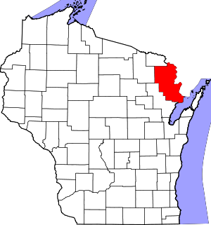 | |
| Villages | ||
| Towns | ||
| CDPs | ||
| Unincorporated communities | ||
| Footnotes | ‡This populated place also has portions in an adjacent county or counties | |
This article is issued from Wikipedia. The text is licensed under Creative Commons - Attribution - Sharealike. Additional terms may apply for the media files.