Route 26 (Iceland)
Landvegur or Route 26 is a national road in Southern Region. It runs from the ring road near Hella through the Landssveit area to the intersection of Þjórsárdalsvegur. From there it is called Sprengisandsleið, although this name is also refers to Route F26, which starts at the end of Route 26 near Þórisvatn.[1]
| |
|---|---|
| Landvegur | |
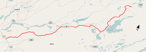 Location of Route 26 | |
| Route information | |
| Length | 127.7 km (79.3 mi) |
| Major junctions | |
| Southern end | |
| Northern end | |
| Highway system | |
| National Roads in Iceland | |
See also
References
- Maps (Map). Google Maps.
This article is issued from Wikipedia. The text is licensed under Creative Commons - Attribution - Sharealike. Additional terms may apply for the media files.