Rothwell, West Yorkshire
Rothwell is a market town in the south-east of the City of Leeds metropolitan borough in West Yorkshire, England. It is situated between Leeds and Wakefield.
| Rothwell | |
|---|---|
 Former Rothwell Town Hall (now closed) | |
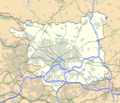 Rothwell 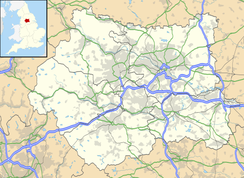 Rothwell Location within West Yorkshire | |
| Population | 20,354 (ward. 2011) |
| OS grid reference | SE345281 |
| Metropolitan borough | |
| Metropolitan county | |
| Region | |
| Country | England |
| Sovereign state | United Kingdom |
| Post town | LEEDS |
| Postcode district | LS26 |
| Dialling code | 0113 |
| Police | West Yorkshire |
| Fire | West Yorkshire |
| Ambulance | Yorkshire |
| UK Parliament | |
It sits in the Rothwell ward of Leeds City Council and Elmet and Rothwell parliamentary constituency. Rothwell is also part of the West Yorkshire Urban Area.
Rothwell has a population of 21,010,[1] and the Rothwell ward has an estimated population of 32,365.[2] At the 2011 Census only the Leeds Metropolitan Ward remained. This had a population of 20,354.[3] The town has benefited from recent improvements in the transport infrastructure, most notably the nearby A1/M1 link road. The nearest railway station is Woodlesford.
History

Rothwell was mentioned in the Domesday Book as "Rodewelle".[4]
One of the royal lodge's documented owners was John of Gaunt, 1st Duke of Lancaster, who is supposed to have killed the last wild boar in England while hunting nearby; hence a boar's head formed part of the arms of the former Rothwell Urban District Council. The parish church (Church Street) is dedicated to Holy Trinity and is on the site of an Anglo Saxon predecessor. The current church, which has a ring of eight bells, is of medieval origins but was substantially rebuilt in the 19th century: the tower retains medieval fabric believed to be from the 15th century.[5]
John Blenkinsop (1783–1831) is buried at Holy Trinity Church. He was a pioneer in the use of steam locomotives on the nearby Middleton Railway.
The town was granted the rights of a market town in the 15th century and a twice-yearly fair. The tradition of a fair is maintained by the annual carnival which is organised by the Rothwell Entertainments Committee.[6] May Day is celebrated beside the stone cross and on the Pastures on the first Monday Bank Holiday in May, while Rothwell Carnival is held in Springhead Park on the second Saturday of July every year.
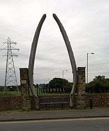
An arch made of whale jawbones has marked the northern boundary by the junction with Wood Lane and the A61 road for over 100 years.[7]
Rothwell is part of the historic Rhubarb Triangle, with the town and surrounding areas famed for having once produced 90% of the world's winter forced rhubarb from the forcing sheds that were common across the fields there.
20th century

St George's Hospital was situated off Wood Lane where now exists Castle Lodge Avenue and associated houses. It was built in 1903 to a design by Leeds architect Edward J. Dodgshun by the Rothwell, Methley and Hunslet Joint Isolation Hospital Committee which was formed under the Isolation Hospitals Act 1893 by an order of the West Riding County Council 10 January 1900. When first constructed it was known as the New Union Workhouse and Infirmary for the Hunslet Union, On being taken over by the Leeds Public Assistance Committee in 1934 it was renamed St George’s Hospital. In 1934 it was transferred to the Leeds Health Committee. In 1948, the hospital was managed by the Leeds Group B Hospital Management Committee. After local government reorganisation in 1974 it was transferred to the Leeds Eastern District and soon after to the Leeds Western District. The hospital was closed in December 1991. From 1934 the hospital provided accommodation for the elderly ill, patients with chronic and acute mental illness, persons with learning disabilities, a maternity ward and a separate isolation ward. The site was developed for housing at the start of the 21st century but the original tall clock tower remains.[8]
Rothwell Temperance Band is a Championship section brass band founded in Rothwell in 1984. Although they do not rehearse in Rothwell itself, they have strong connections with the town and hold many concerts for the local community. They actually rehearse in Wakefield. The closest Champion Section Brass Band is the Yorkshire Imperial Urquhart Travel Band, formerly of the Yorkshire Imperial Copperworks based in Stourton, from which the band is named. The Imps, as they are more commonly known, merged with the original Rothwell Band (founded 1881) in the 1990s.
Rothwell has a long history of coal mining. It was a site of early mining, using a system known as bell pits. Coal mining has been carried out in the area for over 600 years, though coal production stopped on 9 December 1983. There were many local pits including the Fanny, the Rose and Rothwell Water Haigh. In 1995, Leeds City Council and Leeds Groundwork formed a partnership which, together with local residents and community groups, transformed the former colliery into a 50-hectare country park.
Rothwell was constituted an urban district in the West Riding of Yorkshire under the Local Government Act 1894. In 1937 it was expanded by taking in the Methley urban district and Hunslet Rural District.[9]

It was incorporated into the City of Leeds metropolitan borough, West Yorkshire by the Local Government Act 1972. Its inclusion in the Leeds district as opposed to the Wakefield metropolitan district was controversial: originally planned for the Leeds district, it was added to the Wakefield district at the request of residents, but then moved to the Leeds district by the House of Lords.[10]
21st century
The introduction of Leeds Valley Park in the early 21st century and its subsequent expansions[11] have caused concerns for residents due to the parking problems caused on neighbouring Wood Lane.[12] This is despite numerous efforts by local councillors, and the community, to include further parking restrictions.[13][14][15] The issues are having a significant impact on the quality of life for the residents of the town .
Rothwell Urban District
Between 1894 and 1972, Rothwell was constituted as an urban district. This district included the areas of Rothwell, Methley, Oulton, Woodlesford, Stourton, Carlton, Robin Hood, Lofthouse and Thorpe. The Rothwell Urban District had a total population of around 25,000, but if it still existed today, that figure would be closer to 30,000. In 1972 these areas were taken into the newly formed City of Leeds Metropolitan District, although Thorpe, Lofthouse, Carlton and some parts of Robin Hood have a Wakefield postcode.
Town centre
Rothwell has a town centre which includes high street chains as well as independent boutique shops.
Besides the two annual fairs, a Christmas Fayre takes place in the autumn, and a food and drink fayre in early spring.
Since 2007, the town centre has experienced a major redevelopment to respect the local area's conservation status,[16] pedestrianising and restoring the original route of Commercial Street.
Since this renovation, there has been some concern about threats raised against local business by the monolithic Morrisons store.[17][18] However, in 2015 a competing supermarket requested permission to build a store on Marsh Street[19] and in 2017 it was confirmed by local councillor, Karen Bruce, that a second supermarket - ALDI - was to open in the Rothwell area, with construction to begin in 2018.[20] Shortly before construction began, the Morrisons store altered its layout to include a new party section – this caused confusion among residents as they were unable to find items. In early 2019, construction of the new ALDI began and is currently ongoing. This has caused mixed feelings among the residents, whilst some are concerned about the disruption to traffic during the construction phase, others are excited that there will be a greater selection of bread available in the local area.
Education
There are several primary schools in Rothwell including:
- Holy Trinity Rothwell Primary School (Formerly Rothwell Church of England Primary School)
- Rothwell Primary School
- Rothwell Haigh Road Infant School
- Rothwell Victoria Junior School
- Rothwell St. Mary's Catholic School
There are two high schools in the Rothwell area:
- Royds School (Formerly Royds Specialist Language College).
- The Rodillian Academy – the former Rothwell Grammar School (actually in Lofthouse). When it was built it was in the Rothwell Urban District.
Both Royds and Rodillian have sixth form colleges integrated in the school environment.
Other further education colleges in Rothwell:
- Leeds City College – formerly Joseph Priestley College
- WEC International at Springhead Park House offers Christian training in radio, and other media.
Notable and former residents
- Thomas Beckwith - F.A.S (1731–1786) English painter, genealogist and antiquary.
- Mark Bell – musician of LFO fame, worked with Björk.
- John Blenkinsop (1783–1831) – inventor of the rack railway system (buried in the grounds of Holy Trinity Church).
- Martin Kelner – journalist, author, and radio presenter.
- Michelle Hardwick – actress who portrayed Lizzie Hopkirk in The Royal and Vanessa Woodfield in Emmerdale
- Lord Newby of Rothwell – Liberal Democrat & member of the House of Lords.
- Paul Loughran – actor who portrayed Emmerdale character Butch Dingle.
- Joseph Priestley – scientist.
- The Pigeon Detectives – Indie rock band.
- Jane Tomlinson CBE – charity fundraiser, who raised over £1.5 million whilst suffering from terminal cancer.
Sport
- David Batty - footballer, played for Leeds United and Blackburn Rovers, when they were English football champions
- Jason Golden – Harlequins RL footballer.
- Ryan Hall – Leeds Rhinos Rugby League footballer.
- Carl Ablett – Leeds Rhinos Rugby league footballer.
- Jack Hunt – professional footballer, currently playing for Bristol City F.C.
- Garry Schofield – Rugby League footballer & OBE.
- Alan Smith – Ex Leeds United and England Football player
- Jamie Thackray – Hull F.C. Rugby League footballer.
Sports
Football
Rothwell is home to 3 football clubs:
- Rothwell Town J.F.C[21] – who are based at John O'Gaunts Recreation Ground near Rothwell Labour Club
- Rothwell Juniors[22] – Currently based at a purpose-built £1.5 million development at Fleet Lane, Woodlesford. Open age teams known as simply 'Rothwell FC'.
- Rothwell Albion[23] – A newly formed club in the area.
There are numerous teams in the wider Rothwell ward, these include; Carlton Athletic and Robin Hood Athletic, among others.
Golf
Oulton Hall golf course, which is currently owned by hotel group De Vere is located adjacent to Oulton Lane. The only 5-star golf resort in the North of England.[24]
Bowling
Bowling is also a popular sport, and there is a public bowling green in Springhead Park.
Notable places of interest
- Oulton Hall & Golf Course
- Holy Trinity Church, Rothwell
- Rothwell Methodist Church (founded 1764)
Location grid
Places adjacent to Rothwell, West Yorkshire | ||||||||||
|---|---|---|---|---|---|---|---|---|---|---|
| ||||||||||
References
- "Key Figures for 2001 Census: Census Area Statistics". Neighbourhood Statistics. Office for National Statistics. Retrieved 10 February 2011.
- Rothwell UD through time | Administrative history of Local Government District: hierarchies, boundaries Archived 6 May 2008 at the Wayback Machine. Visionofbritain.org.uk. Retrieved on 10 February 2011.
- "City of Leeds Ward population 2011". Neighbourhood Statistics. Office for National Statistics. Retrieved 29 February 2016.
- Rodewelle in the Domesday Book. Retrieved 30 April 2019.
- "Rothwell District C of E Churches | Bricks and Mortar". rothwelldistrictcofechurches.org.uk. Retrieved 27 April 2020.
- "Rothwell Entertainments Committee". Retrieved 28 April 2019.
- "Town claws jaws back in boundary changes". Wakefield Express. 8 August 2003. Retrieved 22 September 2016.
- "Hospital Records Database". National Archives. HM Government. Retrieved 1 May 2012.
- "Relationships / Unit history of Rothwell". A vision of Britain through time. Archived from the original on 6 May 2008. Retrieved 1 November 2007.
- Parliamentary Debates (Hansard). House of Lords. 16 October 1972. col. 1603–1614.
- "Lowell expands at Leeds Valley Park". Commercial News Media. Retrieved 28 April 2019.
- Bruce, Karen (26 October 2018). "Rothwell Wood Lane and Valley Park parking update". Retrieved 28 April 2019.
- Bruce, Karen (28 March 2018). "Action on Wood Lane Parking". Retrieved 28 April 2019.
- Bruce, Karen (29 November 2017). "Wood Lane double parking action". Retrieved 28 April 2019.
- Bruce, Karen (29 April 2017). "Rothwell Labour councillors' news on Wood Lane parking latest plans". Retrieved 28 April 2019.
- "Conservation Area document" (PDF). Leeds City Council documents. Retrieved 1 May 2017.
- https://democracy.leeds.gov.uk/documents/s20645/Item%2015%20b.pdf
- "South Leeds: Rothwell traders mean business in fight to bring back shoppers". Yorkshire Evening Post. Retrieved 28 April 2019.
- https://democracy.leeds.gov.uk/documents/s131688/3%20-%2004467.pdf
- Bruce, Karen (15 September 2017). "Aldi to start building Rothwell site 2018". Retrieved 28 April 2019.
- . S130468224.websitehome.co.uk (13 November 2010). Retrieved 10 February 2011.
- http://full-time.thefa.com/DisplayTeam.do;jsessionid=FA101900179E9115267011CF0C9978BE?teamID=3556986&divisionseason=9159333
- De Vere : Golf. Devere-hotels.com. Retrieved on 10 February 2011.
External links
| Wikimedia Commons has media related to Rothwell, West Yorkshire. |
- The ancient parish of Rothwell: historical and genealogical information at GENUKI.
- LS26.org.uk - area website
- . Encyclopædia Britannica (11th ed.). 1911.
| Authority control |
|
|---|