Rokycany
Rokycany (Czech pronunciation: [ˈrokɪtsanɪ]; German: Rokitzan) is a town in the Plzeň Region of the Czech Republic. It is 17 km (11 mi) east of the region capital Plzeň on the confluence of the River Klabava and the Holoubkov Brook (Czech: Holoubkovský potok). Alternatively, the Holoubkovský potok is referred to as the Borecký potok and the section of the Klabava River down to the confluence as the Padrťský potok. There is another smaller brook (Rakovský potok or Rakováček) in the western part of the town.
Rokycany | |
|---|---|
Town | |
 Panorama of Rokycany | |
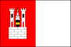 Flag  Coat of arms | |
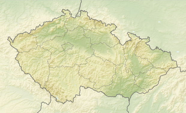 Rokycany Location in the Czech Republic | |
| Coordinates: 49°44′33″N 13°35′44″E | |
| Country | Czech Republic |
| Region | Plzeň |
| District | Rokycany |
| First mentioned | 1110 |
| Government | |
| • Mayor | Václav Kočí |
| Area | |
| • Total | 30.98 km2 (11.96 sq mi) |
| Elevation | 362 m (1,188 ft) |
| Population (2019-01-01[1]) | |
| • Total | 14,192 |
| • Density | 460/km2 (1,200/sq mi) |
| Time zone | UTC+1 (CET) |
| • Summer (DST) | UTC+2 (CEST) |
| Postal code | 337 01 |
| Website | www.rokycany.cz |
The town is in the lowland, 362 metres (1,188 ft) above sea level, bordered by hilly woodlands, especially the Brdy mountains to the east and the Radeč massif.
Rokycany is also the seat of the Municipality with Extended Competence and Municipality with Commissioned Local Authority.
History
The place was inhabited since the Stone Age. Celtic and early Slavic settlements were discovered. Rokycany was first mentioned in 1110. At that time the village owned by the Bishop of Prague, and major Bohemian and German noblemen met here for diplomatic talks with Emperor Henry V. In 1295 a stockade fortifications in Rokycany are mentioned (probably defending the district around the main church). Major changes occurred in the 14th century when the village grew into a town, and a new western part of the settlement with rectangular grid was added. In the 14th century, the main church rebuilt in Gothic style and by 1399 system of town fortification is mentioned. Rokycany took an active role in Hussite movement. Master John of Rokycan (1397—1471), Archbishop of Prague, active during Hussite Wars was born here. In 1406 Rokycany obtained city rights. In the 16th century Rokycany was given rights as free King's city in 1584 making it self-administered entity. The prosperity came to an abrupt end with the Thirty Years' War. Rokycany was repeatedly afflicted by various armies, most notably by the Swedish army led by Banner who completely burned the town. By the end of the war Rokycany's population decreased to 774. Another period of prosperity started in the 18th century. Town was partially destroyed by fire in 1757 (52 houses damaged) and completely destroyed by another fire in 1784 (260 houses damaged). After the fire, the townhall and main church had to be rebuilt, as well as most of the private houses. Thanks to favorable economic conditions of the residents the post-1784 renewal proceeded rather quickly. In the 19th century craft and industry became main source of Rokycany's economy. The traditional iron-ore mining and processing industry was strengthened and linked with coal mining industry in nearby Mirošov (Rokycany District) basin. In 1862 Rokycany was connected via railway with Prague and Plzeň. Industrial development continued for most of the 20th century. Population grew (from 4,187 in 1869 to more than 16,000 in the late 1980s) and the town expanded with new neighborhoods, some of them inspired by concepts of Garden city movement (Rašínov neighborhood in the southern outskirts). On May 7, 1945 Rokycany was liberated by the American army which halted its eastward advance here, meeting with the allied Soviet troops in the eastern part of the town (creating so-called Demarcation line). In the post-World War II era, the development of the town was carried out in line with the ruling communist regime. The new massive construction activity focused on uniform tenement houses, from 1960s built with concrete panels (so-called "panelák"). The local industry was further expanded and the life of the town was strongly influenced by strong army garrison (located in two barracks built in 1899 and 1933 respectively). In 1960 neighboring village Borek was merged with Rokycany, in 1980 another three rural communities (Kamenný Újezd (Rokycany District), Litohlavy, Svojkovice (Rokycany District)) joined Rokycany (however all 3 have separated in the 1990s)
Geography
Rokycany is divided into four districts: "Střed" (Center), "Nové Město" (New Town), "Plzeňské předměstí" (Plzeň Suburb) and "Borek".
Střed encompasses the historical core of the town with two main squares, main church of Panna Marie Sněžná and town-hall. Since 1992 the historical core of Rokycany has been declared protected zone in order to protect the architecture. The border of this district largely follows the path of former town's fortification. The medieval walls are still standing in several short sections. On the southern side the walls have been replaced by a representative avenue (Jiráskova ulice) with several major public buildings such as "sokolovna" (Sokol organization headquarters) from 1903, new railway-station from 1931, gymnázium (grammar-school) from 1905 or municipal bank from 1933.
Nové Město is by far most populous district surrounding the historical core from north, east and south. It evolved from traditional Pražské předměstí suburb which was located on both banks of the Klabava river along the road to Prague (Pražská ulice) and Nerudovo náměstí square. After World War II most of the old suburb was demolished and replaced by several housing projects. With the population growth the built-up area of Nové Město expanded in all directions. There are thus several distinct modern neighborhoods. Práchovna is located in the southeastern section of Rokycany on the banks of the Klabava River. Several industrial estates and colony of cheap tenement houses for local workers from early 20th century form most of Práchovna. Páclovna is situated along the road to Prague on Rokycany's eastern outskirts. It mainly consists of private houses, the Demarcation line memorial is located here (commemorating the meeting of American and Russian troops that occurred here in 1945), Osecký vrch lies in the north along the road to the village of Osek. In 1957 large hospital was built here. There are large parks covering the surrounding slopes (Husovy sady and Kalvárie) and large complex of town swimming-pool and football stadium. Jižní předměstí covers territory south of the Prague-Plzeň railway. It consists of several industrial zones and populous housing projects from the 1950s and 1970s. The military barracks built in 1933 have been converted into a residential and industrial zone recently.
Plzeňské předměstí forms western part of Rokycany. It started in medieval era as a small cluster of rural houses adjoining Rokycany's historical core. In early 17th century Protestant church Nejsvětější Trojice was built here, soon after taken by Catholics. In 19th century Plzeňské předměstí quickly grew along the road to Plzeň (Plzeňská ulice), mainly industrial development was later accompanied by residential houses. In 1920s massive housing project started on Rokycany's southern outskirts. The new neighbourhood was later called Rašínov (Alois Rašín was finance minister of Czechoslovakia, assassinated in 1923). In consists solely of private houses in art-deco style. In 1930's another neighborhood was inaugurated in the western periphery, called Za Rakováčkem. It also features almost exclusively private residential houses.
Borek used to be an independent village located ca.2 km east of Rokycany. In 1960 Borek came under the jurisdiction of Rokycany. The Borecký rybník lake is most notorious landmark of this district. In the 20th century the built-up area of Borek expanded amalgamating the village with Rokycany.
 Main church in Rokycany
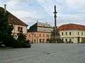 Main square in Rokycany
 Town hall and main square in Rokycany
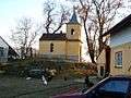 Chapel in Borek, Rokycany
 Railway station from 1931, Rokycany
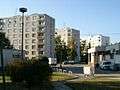 1970's style houses in Rokycany
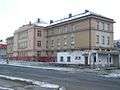 1930s army barracks in Rokycany
Demography
| Historical population | ||
|---|---|---|
| Year | Pop. | ±% |
| 1811 | 2,226 | — |
| 1848 | 3,292 | +47.9% |
| 1869 | 4,187 | +27.2% |
| 1880 | 4,927 | +17.7% |
| 1890 | 5,010 | +1.7% |
| 1900 | 5,501 | +9.8% |
| 1910 | 6,492 | +18.0% |
| 1921 | 6,728 | +3.6% |
| 1930 | 7,741 | +15.1% |
| 1939 | 9,865 | +27.4% |
| 1950 | 8,789 | −10.9% |
| 1961 | 11,934 | +35.8% |
| 1970 | 12,585 | +5.5% |
| 1980 | 15,041 | +19.5% |
| 1991 | 15,188 | +1.0% |
| 2001 | 14,369 | −5.4% |
| 2007 | 14,302 | −0.5% |
| 2008 | 14,705 | +2.8% |
| 2019 | 14,192 | −3.5% |
| Source: unofficial pages of Rokycany by David Borek | ||
In 19th century Rokycany's population quickly expanded pushing the number of inhabitants towards 5,000 in 1880. In the wake of Long Depression (economic slowdown of the 1870s which affected the economy of Austria-Hungary) the growth stopped. In late 1890s however population began to expand again, only to halt during World War I. In post-1918 era Rokycany grew rapidly. In the late 1930s this growth was further spurred by influx of ethnic Czech refugees from Sudetenland. In 1939 Rokycany's population touched 10,000 mark briefly. After World War II many citizens of Rokycany left the town for border regions from where the ethnic Germans were expelled. From the 1950s a new wave of massive growth started, pushing the town's population past 10,000 in the mid 1950s and past 15,000 in the 1980s. Demographic maximum was reached in 1989 with more than 16,000 inhabitants. Since that time the population dropped to ca. 14,000 as a result of economic a social transition and also of separation of 3 villages from the community of Rokycany.
Ethnically, Rokycany has been a predominately Czech settlement since Middle Ages. The German minority accounted for no more than couple of dozens individuals. In 1938 the town's population was boosted by influx of ethnic Czechs fleeing the border regions of Czechoslovakia which had been ceded to Nazi Germany. After 1945 most ethnic Germans were expelled. The ethnic mix of Rokycany was in the post-World War II era enriched by Romas (Gypsies) and Slovaks.
Events
Rokycany hosts Fluff Fest, a vegan hardcore punk festival which draws several thousand visitors from across Europe every July. It is held at the Rokycany airfield, having moved there in 2006 from its original location in Plzeň. The festival has been described as a yearly "strain" on the town, which is otherwise unaccustomed to large numbers of foreign visitors and extreme music adherents, and brings a business boom especially in sales of vegetarian and vegan food.[2]
Notable people
- John of Rokycan, (ca. 1396, Rokycany – 1471, Prague), archbishop of Prague
- Antonín Kraft, (1749, Rokycany – 1820, Vienna), Czech cellist and composer
- Adolf Kraus, (1850, Blovice – 1928, USA), Chicago lawyer, B'nai B'rith officer, lived in Rokycany
- Paula Deppe, (1886–1922), Sudeten German painter
- Čestmír Řanda (1923, Rokycany – 1986, Prague), Czech actor
- Věra Bílá, (1954, Rokycany – 2019, Plzeň), World music Romani singer
- George Uhl, (born 1970, Rokycany), Czech pornographic actor
- Jaroslav Špaček (born 1974, Rokycany), Montreal Canadiens (National Hockey League) defenseman
- Vhrsti (born 1975, Rokycany), Czech illustrator
- Václav Procházka (born 1984, Rokycany), Czech footballer
- Jiří Pehe (born 1955, Rokycany), Czech political analyst and writer
See also
- John of Rokycan
- Borek
- Vršíček
- Radnice coal basin
- Brdy
References
- "Population of municipalities of the Czech republic". Czech Statistical Office. Retrieved 2019-04-30.
- Vaníková, Jana (26 July 2015). "Fluff fest, to je nápor na Rokycany" [Fluff Fest is a strain on Rokycany] (in Czech). Rokycanský deník. Retrieved 9 October 2017.
- "Partnerská města: Rokycany". Město Klatovy. Retrieved 2019-08-21.
External links
- (in Czech) Municipal website
- History of the town, its current state

| Authority control |
|
|---|