Rodovia Dom Pedro I
Rodovia Dom Pedro I (official designation SP-065) is a highway in the state of São Paulo, Brazil.
| |
|---|---|
 | |
| Route information | |
| Length | 145 km (90 mi) |
| Existed | 1972–present |
| Major junctions | |
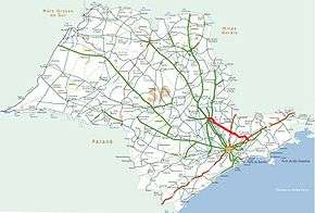
| East end | Rodovia Presidente Dutra, BR 116 in Jacareí |
| SP 348 (Rodovia Anhangüera), km 135 | |
| West end | Rodovia Anhanguera, SP 330 in Campinas |
| Location | |
| Major cities | São Paulo, Brazil (passes through Jacareí, Nazaré Paulista, Bom Jesus dos Perdões, Atibaia, Jarinu, Itatiba, Jaguariúna, Campinas) |
| Highway system | |
| Highways in Brazil São Paulo State Highways | |

One of the most modern and scenic highways in the country, it interconnects the Anhangüera and the Presidente Dutra highways, serving the major cities of Campinas, Atibaia, Jacareí and São José dos Campos. It is 126 km long and crosses a picturesque hilly region full of lakes, dams and temperate forests. The highway intersects the Fernão Dias Highway, between São Paulo and Belo Horizonte, near the city of Atibaia. The part of the highway that runs inside the city of Campinas comprises one leg of the Campinas Beltway (Anel Viário José Magalhães Teixeira).
The highway was named after Emperor Dom Pedro I, partly because it was inaugurated in 1972 and served to commemorate 150 years of Independence. A second roadway was built and the road enhanced to highway standards in 1990.
The highway is managed and maintained by DERSA, a state-owned company, and is a toll road.
Gallery
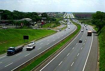 Rodovia Dom Pedro I, km 145, inside Campinas
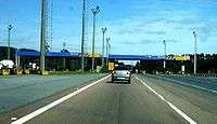 Toll gates near Itatiba
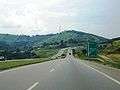 Rodovia Dom Pedro I, near Nazaré Paulista
See also