Rodovia Anhangüera
Rodovia Anhangüera (official designation SP-330) is a highway in the state of São Paulo, Brazil. It is one of the country's busiest transportation corridors. A 2005 survey conducted amongst Brazilian truck drivers rated it as the best transportation axis in the country.
 | |
| Native name | Rodovia Anhanguera |
|---|---|
| Namesake | Bartolomeu Bueno da Silva |
| Type | Double-lane highway |
| Length | 453 km (281 mi) |
| Location | Passes through São Paulo, Cajamar, Jundiai, Louveira, Vinhedo, Valinhos, Campinas, Sumaré, Nova Odessa, Americana, Limeira, Araras, Leme, Pirassununga, Porto Ferreira, Cravinhos, Ribeirão Preto, Orlândia, São Joaquim da Barra, Guará, Ituverava, Igarapava |
| South end | Rua Monte Pascal Lapa, in the city of São Paulo |
| Major junctions |
|
| North end | Igarapava – Next to Minas Gerais State Border |
| Construction | |
| Inauguration | 1940/1948/1950 and 1953/1959/1961 |
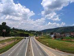
The Anhanguera Highway connects São Paulo with the northern part of the state and its main industrial cities and one of the most productive agricultural areas. It is one of the most important highways in Brazil and one of the busiest, with the highest traffic segment between São Paulo and Campinas, the first to be built. It is duplicated, containing sections with additional tracks and marginal clues. They have heavy traffic, especially of trucks. It is considered, together with the Bandeirantes Highway and Washington Luis Highway, the country's largest financial corridor, since it interconnects some of the state's metropolitan regions such as São Paulo, Campinas and Ribeirão Preto, as well as the Jundiaí Urban Aglomerate and the Central Administrative Region.[1]
History
The route was first used in 1774 as a dirt road between São Paulo city, Jundiaí and Campinas, serving the cattle troops and voyagers who explored the backlands for gold, precious stones and slaves. The original road was built in 1914, by a group of 84 forced labor prisoners, who paved 32 km. It is known today as Estrada Velha de Campinas (Campinas Old Road), with the official designation of SP-332. It was officially inaugurated in 1940 as the first modern, asphalt-paved, four-lane highway in the country.
Anhangüera was the name given by native indigenous people to a famous bandeirante explorer of the 16th century, Bartolomeu Bueno da Silva, who impressed them with tricks of setting fire to a plate full of cachaça. Anhangüera in the Tupi language means "old devil".
Features
The Anhangüera highway connects the city of São Paulo with the northern region of the state and the industrial cities and agricultural regions there. Its busiest section is São Paulo-Campinas, the first section which was inaugurated. It is 86 km long, and serves the cities of Cajamar, Jundiaí, Louveira, Vinhedo, Valinhos and Campinas. Near Valinhos, SP-330 connects to Rodovia Dom Pedro I through the Campinas Beltway (SP-083), and near Campinas, it connects with Rodovia dos Bandeirantes (SP-348) through Rodovia Santos Dumont (SP-075).
Beyond Campinas, the second section goes through the cities of Sumaré, Nova Odessa, Americana, Limeira, Araras, Leme, Pirassununga, Porto Ferreira, Cravinhos and Ribeirão Preto. The third section, the last to be doubled-laned, goes to Orlândia, São Joaquim da Barra, Guará, Ituverava and Igarapava, reaching the border of Minas Gerais state at the Rio Grande, near Uberaba. It is the third longest highway in the state, with 482 km.
Anhanguera is a four-lane highway. It has heavy traffic, especially trucks.
The highway is currently managed by four private companies, and therefore is a toll road:
- AutoBan, from 11 (São Paulo) to 158 km
- InterVias, from 158 to 240 km
- AutoVias, from 240 to 318 km
- ViaNorte, from 318 to 482
References
| Rodovias | |
|---|---|
| Expressways |
|
| Surface streets |
|