Rockbridge, Wisconsin
Rockbridge is a town in Richland County, Wisconsin, United States. The population was 721 at the 2000 census. The unincorporated communities of Rockbridge and Buck Creek are located in the town.
Rockbridge, Wisconsin | |
|---|---|
 Location of Rockbridge, Wisconsin | |
| Coordinates: 43°25′51″N 90°22′2″W | |
| Country | |
| State | |
| County | Richland |
| Area | |
| • Total | 36.2 sq mi (93.7 km2) |
| • Land | 36.2 sq mi (93.7 km2) |
| • Water | 0.0 sq mi (0.0 km2) |
| Elevation | 820 ft (250 m) |
| Population (2000) | |
| • Total | 721 |
| • Density | 19.9/sq mi (7.7/km2) |
| Time zone | UTC-6 (Central (CST)) |
| • Summer (DST) | UTC-5 (CDT) |
| Area code(s) | 608 |
| FIPS code | 55-68675[2] |
| GNIS feature ID | 1584050[1] |
Geography
According to the United States Census Bureau, the town has a total area of 36.2 square miles (93.7 km²), of which, 36.2 square miles (93.7 km²) of it is land and 0.03% is water.
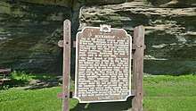
Pier Park lies along the west side of the town, and the Pine River runs through the park; this park contains a natural rock bridge across the river. The town was named after this natural feature. The park has two historical markers: one indicating the unique rock formation and the other recognizing its significance as a campsite during the Black Hawk War of 1832.[3][4]
Demographics
At the 2000 census there were 721 people in 263 households, including 201 families, in the town. The population density was 19.9 people per square mile (7.7/km²). There were 315 housing units at an average density of 8.7 per square mile (3.4/km²). The racial makeup of the town was 98.06% White, 0.69% African American, 0.14% Native American, 0.14% Asian, and 0.97% from two or more races. Hispanic or Latino of any race were 1.11%.[2]
Of the 263 households 37.3% had children under the age of 18 living with them, 70.0% were married couples living together, 4.6% had a female householder with no husband present, and 23.2% were non-families. 19.8% of households were one person and 10.3% were one person aged 65 or older. The average household size was 2.74 and the average family size was 3.17.
The age distribution was 30.7% under the age of 18, 4.3% from 18 to 24, 23.7% from 25 to 44, 27.6% from 45 to 64, and 13.7% 65 or older. The median age was 41 years. For every 100 females, there were 110.8 males. For every 100 females age 18 and over, there were 100.8 males.
The median household income was $41,563 and the median family income was $45,804. Males had a median income of $30,556 versus $21,042 for females. The per capita income for the town was $17,269. About 6.9% of families and 8.5% of the population were below the poverty line, including 14.3% of those under age 18 and 9.4% of those age 65 or over.
References
- "US Board on Geographic Names". United States Geological Survey. 2007-10-25. Retrieved 2008-01-31.
- "U.S. Census website". United States Census Bureau. Retrieved 2008-01-31.
- Pier Park
- Wisconsin Explorer-Pier Park
Municipalities and communities of Richland County, Wisconsin, United States | ||
|---|---|---|
| City | 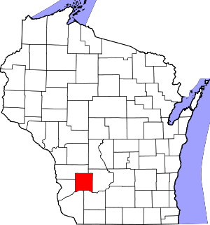 | |
| Villages | ||
| Towns | ||
| CDPs | ||
| Unincorporated communities |
| |
| Former communities | ||
| Footnotes | ‡This populated place also has portions in an adjacent county or counties | |