Rivera
Rivera (Spanish pronunciation: [riˈβeɾa]) is the capital of Rivera Department of Uruguay. The border with Brazil joins it with the Brazilian city of Santana do Livramento, which is only a street away from it, at the north end of Route 5. Together, they form an urban area of around 200,000 inhabitants. As of the census of 2011, it is the sixth most populated city of Uruguay.
Rivera | |
|---|---|
Capital city | |
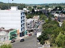
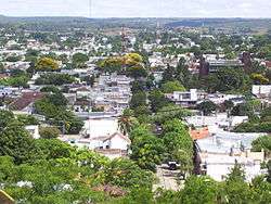 View of Rivera from Cerro Marconi | |
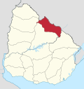
 Rivera Location in Uruguay | |
| Coordinates: 30°54′9″S 55°33′2″W | |
| Country | |
| Department | |
| Elevation | 219 m (719 ft) |
| Population (2011 Census) | |
| • Total | 64,465 |
| • Demonym | Riverense |
| Time zone | UTC -3 |
| Postal code | 40000 |
| Dial plan | +598 462 (+5 digits) |
History
On 21 March 1860 a pueblo (village) named Pereira was created by the Act of Ley Nº 614.
On 7 May 1862, it was substituted by the villa (town) named Ceballos and founded by the Act of Ley Nº 704,[1] in honour of the Spanish viceroy Pedro de Cevallos. In July 1867 it took on the official name Rivera and was recognized as a villa. The Brazilian town Santana do Livramento already existed just across the border. On 1 October 1884, it became capital of the Department of Rivera by the Act of Ley Nº 1.757. Its status was elevated to ciudad (city) on 10 June 1912 by the Act of Ley Nº 4.006.[1]
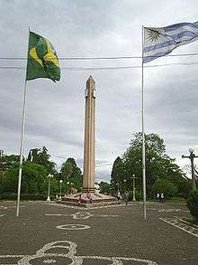
In 1943, the Plaza Internacional Rivera-Livramento (see photo) was built to celebrate the Fifth Conference of the Commission Mixta for Mixed Limits and as a hope for the future integration of the two towns, claimed to be the only international square in the world. From 1851 to this day, inhabitants of both communities are free to move in both sides.[2] Today, duty-free shops are one of the main economic resources of Rivera.[3]
The first inhabitants of the city were Spaniards, Italians, Portuguese and some Brazilians immigrants who lived in Santana do Livramento, on the Brazilian side of the border.
Border control
The two cities of Rivera (Uruguay) and Santana do Livramento (Brazil) maintain an open border without any physical border barriers or checkpoints. Inhabitants of the twin cities are free to move anywhere within the two communities without having to undergo checks.
Travellers crossing the border here and proceeding further into the other country are required to complete border formalities at an integrated border control post located at Siñeriz Shopping in Rivera. The integrated border control post housing the immigration and customs offices of both countries was inaugurated on 28 December 2016.[4] Previously, travellers had to visit various offices located in different parts of the twin cities.[5]
Economy
One of the main economic activities of the city of Rivera is the free-shop stores, aimed at Brazilian neighbors, mainly coming from the cities of Rio Grande do Sul, near the border with Uruguay, making Rivera a popular destination for buying imported dollar products. With the fall in the price of the US currency, many devices can be bought for prices up to 40% smaller than similar ones sold in Brazil. The Rivera shopping limit is $300 per person. Purchases above this amount must be declared at the Federal Revenue Office for the payment of the corresponding import tax so that the product can legally enter Brazil.
It is also worth mentioning the existence of a casino, located on one of the avenues where the border between the two countries runs. Within the department, livestock farming, agriculture and afforestation predominate.
Population
In 2011, Rivera had a population of 64,465[6]
| Year | Population |
|---|---|
| 1867 | 341 |
| 1889 | 1,000 |
| 1908 | 8,986 |
| 1963 | 41,266 |
| 1975 | 48,780 |
| 1985 | 57,314 |
| 1996 | 62,859 |
| 2004 | 64,426 |
| 2011 | 64,465 |
Source: Instituto Nacional de Estadística de Uruguay[1]
Climate
The climate in Rivera, as well as in Santana do Livramento, is humid subtropical (Cfa, according to the Köppen climate classification), temperate in the winter and relatively warm in the summer.
| Climate data for Rivera, Uruguay (1980–2009) | |||||||||||||
|---|---|---|---|---|---|---|---|---|---|---|---|---|---|
| Month | Jan | Feb | Mar | Apr | May | Jun | Jul | Aug | Sep | Oct | Nov | Dec | Year |
| Record high °C (°F) | 41.4 (106.5) |
44.0 (111.2) |
40.0 (104.0) |
34.4 (93.9) |
31.2 (88.2) |
30.2 (86.4) |
29.6 (85.3) |
33.6 (92.5) |
36.1 (97.0) |
36.4 (97.5) |
41.5 (106.7) |
43.0 (109.4) |
44.0 (111.2) |
| Average high °C (°F) | 30.5 (86.9) |
28.7 (83.7) |
27.3 (81.1) |
23.7 (74.7) |
20.5 (68.9) |
16.9 (62.4) |
16.6 (61.9) |
19.9 (67.8) |
20.6 (69.1) |
23.8 (74.8) |
26.5 (79.7) |
29.6 (85.3) |
23.7 (74.7) |
| Daily mean °C (°F) | 24.6 (76.3) |
23.6 (74.5) |
22.2 (72.0) |
18.9 (66.0) |
15.7 (60.3) |
12.9 (55.2) |
12.4 (54.3) |
14.6 (58.3) |
15.5 (59.9) |
18.5 (65.3) |
20.8 (69.4) |
23.5 (74.3) |
18.6 (65.5) |
| Average low °C (°F) | 18.7 (65.7) |
18.4 (65.1) |
17.2 (63.0) |
14.1 (57.4) |
10.8 (51.4) |
8.8 (47.8) |
8.1 (46.6) |
9.3 (48.7) |
10.3 (50.5) |
13.2 (55.8) |
15.1 (59.2) |
17.3 (63.1) |
13.5 (56.3) |
| Record low °C (°F) | 6.0 (42.8) |
7.0 (44.6) |
5.0 (41.0) |
−3.6 (25.5) |
−1.0 (30.2) |
−5.0 (23.0) |
−4.8 (23.4) |
−3.0 (26.6) |
−2.4 (27.7) |
0.4 (32.7) |
4.0 (39.2) |
6.4 (43.5) |
−5.0 (23.0) |
| Average precipitation mm (inches) | 136.4 (5.37) |
160.4 (6.31) |
133.1 (5.24) |
181.9 (7.16) |
148.3 (5.84) |
110.7 (4.36) |
91.2 (3.59) |
87.0 (3.43) |
130.9 (5.15) |
149.4 (5.88) |
150.4 (5.92) |
125.2 (4.93) |
1,605 (63.19) |
| Average precipitation days (≥ 1.0 mm) | 8 | 7 | 8 | 7 | 7 | 8 | 9 | 8 | 8 | 8 | 7 | 6 | 91 |
| Average relative humidity (%) | 65 | 69 | 72 | 76 | 78 | 79 | 77 | 72 | 72 | 71 | 68 | 64 | 72 |
| Mean monthly sunshine hours | 266.6 | 217.5 | 223.2 | 177.0 | 167.4 | 135.0 | 158.1 | 176.7 | 183.0 | 217.0 | 246.0 | 266.6 | 2,434.1 |
| Mean daily sunshine hours | 8.6 | 7.7 | 7.2 | 5.9 | 5.4 | 4.5 | 5.1 | 5.7 | 6.1 | 7.0 | 8.2 | 8.6 | 6.7 |
| Source 1: Instituto Nacional de Investigación Agropecuaria[7] | |||||||||||||
| Source 2: Dirección Nacional de Meteorología (precipitation days 1961–1990, extremes 1944–1994)[8][9] | |||||||||||||
Places of worship
- Church of the Immaculate Conception (Roman Catholic)
- Parish Church of St. Dominic (Roman Catholic)
- Parish Church of the Sacred Heart (Roman Catholic)
- St. Peter Parish Church (Roman Catholic)
Consular representation
Brazil keeps a Consulate in Rivera, located at 1159 Calle Ceballos.
Notable local people
- Aparicio Méndez, from Rivera, was President of Uruguay from 1976 to 1981. He was never elected democratically and was chosen by the military dictatorship.
- Rodrigo Mora, a current football player for Club Atlético River Plate, was born in Rivera.
- Luiz Eduardo Garagorri, professional mixed martial artist, currently signed for UFC.
Transportation
There are regular bus services to Montevideo. A rail service to Tacuarembó has been run intermittently.
Rivera is served by Pres. Gral. Óscar D. Gestido International Airport, which receives light aircraft and a regular service by Brazilian airline GOL to Porto Alegre.

Sports
The Estadio Atilio Paiva Olivera holds 27,115 people and was used in the 1995 Copa América.
The Skatepark of Rivera is on Presidente Viera Street.
Twin towns – sister cities
Rivera is twinned with:
|
References
- "Statistics of urban localities (1867–2004) (see also "Ceballos" & "Pereira")" (PDF). INE. 2012. Retrieved 4 September 2012.
- "Parque Internacional". Intendencia Departamental de Rivera. 2011. Archived from the original on 26 May 2012. Retrieved 26 February 2012.
- "La frontera dorada". El Observador. 26 June 2011. Retrieved 26 February 2012.
- "Se inauguró nuevo local del Área de Control Integrado de Turismo Uruguay-Brasil en Rivera" (in Spanish). Dirección Nacional de Aduanas. 4 January 2017. Retrieved 13 May 2019.
- "Uruguay y Brasil inauguraron en Rivera el primer paso de frontera integrado" (in Spanish). Hosteltur.com. 29 December 2016. Retrieved 13 May 2019.
- "Censos 2011 Cuadros Rivera". INE. 2012. Archived from the original on 14 November 2012. Retrieved 25 August 2012.
- Castaño, José; Giménez, Agustín; Ceroni, Mauricio; Furest, José; Aunchayna, Rossina. "Caracterización Agroclimática del Uruguay 1980–2009" (PDF) (in Spanish). Instituto Nacional de Investigación Agropecuaria. Archived from the original (PDF) on 12 December 2018. Retrieved 13 December 2018.
- "Estadísticas climatológicas" (in Spanish). Dirección Nacional de Meteorología. Retrieved 10 October 2012.
- "RECORDS METEOROLOGICOS EN EL URUGUAY" (in Spanish). Dirección Nacional de Meteorología. Retrieved 28 September 2016.