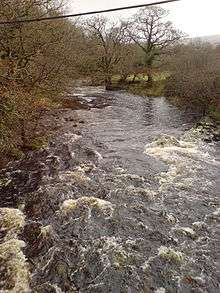
River Tavy
The Tavy (/ˈteɪvi/) is a river on Dartmoor, Devon, England. The name derives from the Brythonic root "Tam", once thought to mean 'dark' but now generally understood to mean 'to flow'.[1] It has given its name to the town of Tavistock and the villages of Mary Tavy and Peter Tavy. It is a tributary of the River Tamar and has as its own tributaries:
| River Tavy routemap | ||||||||||||||||||||||||||||||||||||||||||||||||||||||||||||||||||||||||||||||||||||||||||||||||||||||||||||||||||||||||||||||||||||||||||||||||||||||||||||||||||||||||||||||||||||||||||||||||||||||||||||||||||||||||||||
|---|---|---|---|---|---|---|---|---|---|---|---|---|---|---|---|---|---|---|---|---|---|---|---|---|---|---|---|---|---|---|---|---|---|---|---|---|---|---|---|---|---|---|---|---|---|---|---|---|---|---|---|---|---|---|---|---|---|---|---|---|---|---|---|---|---|---|---|---|---|---|---|---|---|---|---|---|---|---|---|---|---|---|---|---|---|---|---|---|---|---|---|---|---|---|---|---|---|---|---|---|---|---|---|---|---|---|---|---|---|---|---|---|---|---|---|---|---|---|---|---|---|---|---|---|---|---|---|---|---|---|---|---|---|---|---|---|---|---|---|---|---|---|---|---|---|---|---|---|---|---|---|---|---|---|---|---|---|---|---|---|---|---|---|---|---|---|---|---|---|---|---|---|---|---|---|---|---|---|---|---|---|---|---|---|---|---|---|---|---|---|---|---|---|---|---|---|---|---|---|---|---|---|---|---|---|---|---|---|---|---|---|---|---|---|---|---|---|---|---|---|
| ||||||||||||||||||||||||||||||||||||||||||||||||||||||||||||||||||||||||||||||||||||||||||||||||||||||||||||||||||||||||||||||||||||||||||||||||||||||||||||||||||||||||||||||||||||||||||||||||||||||||||||||||||||||||||||

At Tavistock it feeds a canal running to Morwellham Quay.
Its mouth is crossed by the Tavy Bridge which carries the Tamar Valley railway line.
Navigation
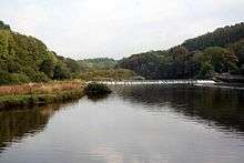
The river is navigable inland as far as Lopwell, where a weir marks the normal tidal limit, about a 9-mile (14 km) journey from North Corner Quay at Devonport.[2] River transport was an important feature of the local farming, mining, tourism and forestry economies.[3][4]
The Queen's Harbour Master for Plymouth[5] is responsible for managing navigation on the River Tavy up to the normal tidal limit.[6]
See also
- Tamar–Tavy Estuary SSSI
Bibliography
- Armstrong, Robin (1985) The Painted Stream, London: Dent ISBN 0-460-04702-7
References
- Owen, Hywel Wyn (1998). University of Wales Press. Cardiff, United Kingdom: University of Wales Press. p. 103. ISBN 0708314589.
- Ordnance Survey mapping
- SC871 Rivers Tamar, Lynher and Tavy (Map). Admiralty. 2000. D inset.
- "Welcome to Lopwell" (PDF). Plymouth City Council. Archived from the original (PDF) on 9 June 2011. Retrieved 5 July 2011.
- Queen's Harbour Master Plymouth
- The Dockyard Port of Plymouth Order 1999
| Authority control |
|
|---|