River Asker
The River Asker is a small river in Dorset, England. It rises on the chalk slopes of Eggardon Hill,[1] approximately five miles (8 km) east of Bridport. It flows west-northwest through the villages of Askerswell (to which it gives its name), Uploders (where many cottages have gardens backing onto the river) and Loders. Here it heads west towards Bradpole, where it is joined by the small Mangerton River[1] flowing in from the north. It then flows southwest into Bridport, passing underneath the A3066 and B3162 roads in the town. In this section there are weirs and fish ladders.[2] South of the B3162, between Bridport and Bothenhampton, the river also forms the western boundary of the Askers Meadow Nature Reserve, which was designated a Local Nature Reserve in 2004.[3] The river then flows under the B3157 road and joins the River Brit beside Palmers Brewery[1] in the south of the town.
| Asker | |
|---|---|
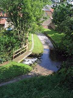 A ford on the River Asker near Uploders | |
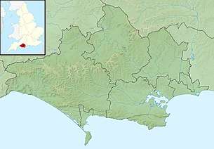 Location within Dorset | |
| Location | |
| Country | United Kingdom |
| County | Dorset |
| Physical characteristics | |
| Source | |
| • location | Eggardon Hill, near Askerswell, Dorset |
| • coordinates | 50°45′N 2°39′W |
| Mouth | |
• location | Bridport, Dorset |
• coordinates | 50°43′N 2°45′W |
Notes
- "River Brit & River Asker". Frome, Piddle & West Dorset Fisheries Association. Retrieved 10 February 2014.
- "Chance to learn about fish ladders on River Asker walk". Newsquest Media (Southern) Ltd (Dorset Echo). 9 October 2012. Retrieved 10 February 2014.
- "Askers Meadow". Natural England. Retrieved 10 February 2014.
| Unitary authorities | |
|---|---|
| Major settlements | |
| Rivers | |
| Topics | |