Ridge Pike
Ridge Pike is a major historic road that opened in 1706 that originally connected Wissachickon Creek to Perkiomen Creek.[1] Inside Philadelphia, it is called Ridge Avenue. Going westward, it traverses many eastern Pennsylvania neighborhoods including Conshohocken and beyond, eventually connecting with Germantown Pike to the west.[2] 13th Street and Ridge Avenue is notable for being the location of Benjamin Franklin's kite experiment which led to the discovery of electricity.
| Ridge Pike | |
|---|---|
| Route information | |
| Existed | 1706–present |
| Major junctions | |
| West end | High Street near Pottstown |
| |
| East end | Wood Street in Philadelphia |
| Location | |
| Counties | Montgomery, Philadelphia |
| Highway system | |
| |
Route description
Montgomery County
Ridge Pike begins at an intersection with High Street, Evergreen Road, and Rupert Road on the border of Lower Pottsgrove Township and Limerick Township in Montgomery County. West of here, the road becomes High Street and continues west through Lower Pottsgrove Township, the borough of Pottstown, and West Pottsgrove Township to the Berks County line. In Berks County, the road becomes Benjamin Franklin Highway and comes to an interchange with the west end of the US 422 freeway that bypasses Pottstown, at which point Benjamin Franklin Highway becomes part of US 422. From the western terminus at the High Street, Evergreen Road, and Rupert Road intersection, Ridge Pike heads east into Limerick Township as part of State Route 4031, an unsigned quadrant route that is a four-lane undivided road. The road comes to a westbound exit and eastbound entrance that connects to Evergreen Road and an interchange with the US 422 freeway. From here, Ridge Pike continues east as a four-lane undivided road through commercial areas, narrowing to two lanes as it passes to the north of Heritage Field Airport. The road gains a center left-turn lane as it heads through a mix of homes and businesses with some fields, curving to the southeast. Ridge Pike becomes a four-lane undivided road as it continues southeast, turning back into a three-lane road with a center left-turn lane. The road heads past businesses as it runs through the community of Limerick and intersects Swamp Pike, where it narrows to two lanes and runs past homes. Ridge Pike gains a center left-turn lane as it continues southeast through residential and commercial development and some farmland and woodland. The roadway loses the center turn lane and becomes four lanes as it passes businesses and comes to an intersection with Township Line Road, at which point it heads into Upper Providence Township. Here, the name of the road becomes West Main Street as it turns into a three-lane road with a center left-turn lane and runs through residential areas.[3][4]
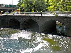
The road enters the borough of Trappe and narrows to two lanes as it passes homes and some businesses, coming to an intersection with PA 113. West Main Street continues through developed areas and crosses into the borough of Collegeville, where it becomes East Main Street and runs through residential areas and passes south of the Ursinus College campus. The road curves to the south-southeast and passes through the commercial downtown of Collegeville before it crosses the Perkiomen Trail and comes to an intersection with PA 29. At this point, PA 29 turns east onto East Main Street for a block before it splits to the north. Ridge Pike heads east and crosses the Perkiomen Creek on the Perkiomen Bridge into Lower Providence Township, where it reaches an intersection with the western terminus of Germantown Pike. From here, Ridge Pike turns southeast and becomes a four-lane undivided road that passes commercial establishments. The road becomes three lanes with two westbound lanes and one eastbound lane as it heads into forested areas of Evansburg State Park and becomes two lanes as it crosses Skippack Creek. Ridge Pike gains a second eastbound lane as it passes through more of the state park. The road leaves Evansburg State Park and heads into wooded areas with residences. The road becomes three lanes with a center left-turn lane as it passes through commercial areas in the community of Eagleville. Ridge Pike continues through a mix of residential and business areas and curves to the south-southeast. The road passes businesses as it comes to an intersection with PA 363 at Park Avenue in the community of Trooper, at which point SR 4031 ends and PA 363 turns southeast to follow Ridge Pike. Ridge Pike continues through commercial areas before PA 363 splits to the southwest along Trooper Road.[3][4]
Upon crossing Trooper Road, the road enters West Norriton Township and becomes West Main Street, which is designated as SR 3009. West Main Street heads southeast past businesses and passes northeast of a golf course. The road narrows to two lanes as it continues through commercial areas, coming to an intersection with Egypt Road in the community of Jeffersonville. Past this intersection, West Main Street widens to four lanes and heads through residential areas with some businesses. The road continues southeast through wooded neighborhoods before passing commercial establishments. The road reaches the western border of the borough of Norristown, where SR 3009 ends and West Airy Street, which is one-way westbound, joins West Main Street. At this point, West Main Street heads into Norristown as a local road that has two eastbound lanes and one westbound lane. The road runs southeast through urban areas of homes with some businesses. Farther southeast, West Main Street crosses Stony Creek and SEPTA's Manayunk/Norristown Line at-grade south of the Main Street station before it intersects southbound US 202 at Markley Street. At this point, West Main Street passes businesses and heads east-southeast into the commercial downtown of Norristown as a two-lane road. The road becomes East Main Street upon crossing Swede Street and passes south of the Montgomery County Courthouse before running through more of the downtown area. East Main Street crosses northbound US 202 at Dekalb Street and leaves downtown Norristown, continuing through urban residential and business areas. The road gains a center left-turn lane and runs east past commercial establishments.[3][4]
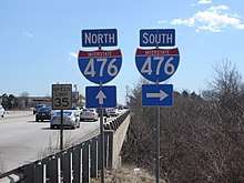
The road leaves Norristown for Plymouth Township and becomes Ridge Pike again. Ridge Pike becomes a county road that runs through a mix of homes and businesses in the communities of Black Horse and Mogeetown, becoming a five-lane road with a center left-turn lane and turning to the southeast. The road loses the center turn lane and passes over the Pennsylvania Turnpike (I-276) and Norfolk Southern's Dale Secondary railroad line, running through commercial areas and coming to a bridge over Norfolk Southern's Morrisville Connecting Track railroad line. Ridge Pike heads east past several businesses, curving southeast and becoming a divided highway at the Alan Wood Road intersection that has a westbound jughandle. From here, the road becomes SR 3056 and passes over the Cross County Trail before it comes to an interchange with I-476. Past this interchange, Ridge Pike continues through commercial areas and passes through the community of Seven Stars, where SR 3056 ends at an intersection with Chemical Road, Colwell Road, and North Lane. At this point, Ridge Pike turns east and becomes a five-lane road with a center left-turn lane. The road comes to an intersection with Butler Pike in the community of Harmonville, at which point it enters Whitemarsh Township. Ridge Pike becomes four lanes and heads into residential areas, passing to the south of a golf course. The road crosses Joshua Road and continues southeast through suburban areas of homes with some businesses. Farther southeast, Ridge Pike becomes a three-lane road with two westbound lanes and one eastbound lane, heading into Springfield Township and running through wooded areas of development.[3][4]
Philadelphia County

Upon intersecting Northwestern Avenue, the road heads into the city of Philadelphia in Philadelphia County and becomes Ridge Avenue, which is designated as SR 3009. Ridge Avenue heads south-southeast as a five-lane road with a center left-turn lane through a mix of residential and commercial areas in the Andorra neighborhood. The road heads south and becomes a six-lane road as it comes to a southbound exit and northbound entrance with Henry Avenue. At this point, Ridge Avenue becomes a two-lane undivided road that heads south-southeast into the Roxborough neighborhood, passing a mix of homes and businesses. The road curves south and then southeast as it continues through the neighborhood. Ridge Avenue continues southeast past several businesses and some homes, passing northeast of Roxborough High School. The road heads into more urban areas of homes and businesses as it heads into the downtown area of Roxborough. Ridge Avenue continues south-southeast through urban areas and passes west of Roxborough Memorial Hospital. The road passes urban homes and curves to the southwest into the Wissahickon neighborhood, descending a hill. Ridge Avenue curves south and passes over SEPTA's Manayunk/Norristown Line before it makes a turn to the southeast and passes south of the Wissahickon station along the SEPTA line. The road heads through commercial areas and passes north of SEPTA's Wissahickon Transportation Center before it crosses Wissahickon Creek. At this point, Ridge Avenue comes to an interchange that connects to I-76 (Schuylkill Expressway) and US 1 (City Avenue) across the Schuylkill River, Kelly Drive, and Lincoln Drive.[3][5]
Past this interchange, Ridge Avenue heads into the East Falls neighborhood and heads east-southeast through urban residential areas with some businesses. The road passes under the Twin Bridges which carry US 1 (Roosevelt Expressway) across the Schuylkill River, at which point it comes to ramps that provide access to northbound US 1 and from southbound US 1, before crossing under CSX's Trenton Subdivision railroad line. Ridge Avenue intersects Allegheny Avenue and turns south, passing between Laurel Hill Cemetery to the west and urban development to the east. The road intersects US 13 at Hunting Park Avenue, at which point US 13 turns south to follow Ridge Avenue. Ridge Avenue heads southeast between Fairmount Park to the west and urban homes to the east. US 13 splits to the south onto 33rd Street north of SEPTA's 33rd and Dauphin Bus Loop and Ridge Avenue continues southeast into the Strawberry Mansion neighborhood, passing through urban areas of homes. The road passes southwest of Strawberry Mansion High School past 32nd Street. Ridge Avenue continues through urban development and passes over Amtrak's Northeast Corridor. Farther southeast, Ridge Avenue crosses Cecil B. Moore Avenue and heads into the Fairmount neighborhood, where it passes to the east of Girard College and comes to an intersection with Girard Avenue, which carries SEPTA's Route 15 trolley line. Following this, the road continues southeast through urban areas of homes and comes to an intersection with Fairmount Avenue and PA 611 (Broad Street), the latter of which SEPTA's Broad Street Line subway runs underneath. At this point, SEPTA's Broad–Ridge Spur subway line runs underneath Ridge Avenue and the road runs through more urban areas, coming to an intersection with Spring Garden Street. At this point, SR 3009 ends and road becomes a city street, passing under the abandoned Reading Viaduct. Upon crossing Callowhill Street, Ridge Avenue becomes one-way northbound and ends at an intersection with Wood Street north of Center City. The Broad–Ridge Spur subway line continues south into Center City.[3][5]
History
What is now Ridge Pike was originally part of two 19th-century turnpikes. The Perkiomen and Reading Turnpike Company was chartered to build a turnpike from the Perkiomen Bridge in Collegeville northwest to Reading via Trappe and Pottstown. Construction of the Perkiomen and Reading Turnpike began on March 22, 1811 and was completed on November 15, 1815. The Ridge Turnpike Road Company was chartered to build a turnpike from Philadelphia northwest to the Perkiomen Bridge in Collegeville via Norristown. Construction of the Ridge Turnpike began in 1812 and was completed in 1816. The Ridge Turnpike served to transport produce, marble, and lime to Philadelphia along with provide a connection from Philadelphia to Reading and Northumberland.[6]
Major intersections
| County | Location | mi | km | Destinations | Notes |
|---|---|---|---|---|---|
| Montgomery | Lower Pottsgrove–Limerick township line | SR 4031 west (High Street) / SR 4026 (Evergreen Road) / Rupert Road | Western terminus | ||
| Limerick Township | Westbound exit and eastbound entrance | ||||
| Trappe | |||||
| Collegeville | West end of PA 29 overlap | ||||
| East end of PA 29 overlap | |||||
| Lower Providence Township | Germantown Pike east | Western terminus of Germantown Pike; no left turn from Germantown Pike to eastbound Ridge Pike | |||
| West end of PA 363 overlap | |||||
| Lower Providence–West Norriton township line | East end of PA 363 overlap | ||||
| Norristown | |||||
| Plymouth Township | I-476 exit 18 | ||||
| Philadelphia | Philadelphia | Henry Avenue south | Eastbound exit and westbound entrance | ||
| Interchange | |||||
| Interchange; access to northbound US 1 and from southbound US 1 | |||||
| West end of US 13 overlap | |||||
| East end of US 13 overlap | |||||
| Wood Street | Eastern terminus | ||||
1.000 mi = 1.609 km; 1.000 km = 0.621 mi
| |||||
See also

References
- "History | Whitemarsh Township, PA - Official Website". www.whitemarshtwp.org.
- "Philadelphia History:Ridge Stret (Ridge Avenue)". www.ushistory.org.
- Google (January 24, 2019). "Ridge Pike" (Map). Google Maps. Google. Retrieved January 24, 2019.
- Montgomery County, Pennsylvania Highway Map (PDF) (Map). PennDOT. 2018. Retrieved January 19, 2019.
- Philadelphia County, Pennsylvania Highway Map (PDF) (Map). PennDOT. 2018. Retrieved January 24, 2019.
- Mowry, C. Documents, Accompanying the Report of the Committee, on Roads, Bridges and Inland Navigation Read in the Senate of Pennsylvania on the 23d March 1822 (PDF). Pennsylvania Senate. Retrieved December 2, 2019.