Rhode Island Route 117
Route 117 is a 28.4-mile-long (45.7 km) state route in the U.S. state of Rhode Island. Its western terminus is at Route 14 in Coventry, and its eastern terminus is at U.S. Route 1A (US 1A) in Cranston.
| ||||
|---|---|---|---|---|
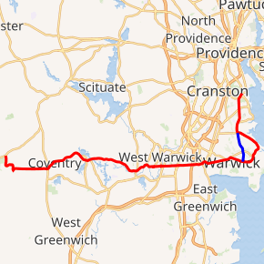
Route 117 highlighted in red | ||||
| Route information | ||||
| Length | 28.4 mi[1] (45.7 km) | |||
| Existed | 1922–present | |||
| Major junctions | ||||
| West end | ||||
| East end | ||||
| Location | ||||
| Counties | Kent, Providence | |||
| Highway system | ||||
Rhode Island Routes
| ||||

Route description
- Coventry: 14.0 miles (22.5 km); Route 14 to West Warwick town line
- Flat River Road, Main Street and Washington Street
- West Warwick: 1.8 miles (2.9 km); Coventry town line to Warwick city line
- West Warwick Avenue, Main Street and Legris Avenue
- Warwick: 8.4 miles (13.5 km); West Warwick town line to Cranston city line
- Legris Avenue, Centerville Road, [Post Road] (Greenwich Avenue, Veterans Memorial Drive, Post Road), West Shore Road, Shore Road and Warwick Avenue
- Cranston: 0.6 miles (1.0 km); Warwick city line to US 1A (Intersection of Warwick Avenue, Norwood Avenue and Broad Street)
- Warwick Avenue
History
Route 117 was one of the original Rhode Island State highways, instated in 1922. Its alignment has changed little since that time.
In the late 1990s, Route 117's eastern terminus was cut back. Originally, Route 117 stayed with Broad Street through Cranston and into Providence, ending at U.S. 1. The reason the eastern terminus was trimmed back is unclear.
Major intersections
| County | Location | mi[1] | km | Destinations | Notes |
|---|---|---|---|---|---|
| Kent | Coventry | 0.0 | 0.0 | Western terminus | |
| Greene | 4.5 | 7.2 | |||
| Coventry | 12.5 | 20.1 | Western terminus of concurrency with Route 33 | ||
| 12.7 | 20.4 | Southern terminus of Route 116 | |||
| 14.0 | 22.5 | Eastern terminus of concurrency with Route 33 | |||
| Warwick | 16.0 | 25.7 | Interchange | ||
| 17.1 | 27.5 | Exit 10 on I-95 | |||
| 17.7 | 28.5 | Eastern terminus of Route 115 | |||
| 17.9 | 28.8 | Southern terminus of Route 5 | |||
| 19.8 | 31.9 | Eastern terminus of Route 113 | |||
| 21.2 | 34.1 | Southern terminus of Route 117A | |||
| 25.2 | 40.6 | Northern terminus of Route 117A | |||
| 27.1 | 43.6 | Western terminus of concurrency with US 1A | |||
| Pawtuxet River | 27.6 | 44.4 | Bridge | ||
| Providence | Cranston | 28.0 | 45.1 | Eastern terminus of Route 12 | |
| 28.4 | 45.7 | Northern terminus; northern terminus of concurrency with US 1A | |||
1.000 mi = 1.609 km; 1.000 km = 0.621 mi
| |||||
Notes
Route 117 ends abruptly while concurrent with US 1A at the intersection of Broad Street, Warwick Avenue and Norwood Avenue. At this intersection, US 1A makes a turn off Broad Street onto Norwood Avenue while Route 117 ends.
Route 117A
| |
|---|---|
| Location | Warwick |
| Length | 2.3 mi[2] (3.7 km) |
Route 117A is a numbered State Highway running 2.3 miles (3.7 km) in Rhode Island.
Route description
Route 117A takes the following route through the State:
- Warwick: 2.3 miles (3.7 km); Route 117 to Route 117
- Oakland Beach Avenue
- Warwick Avenue
Route 117A is a shorter route than the part of Route 117 that it bypasses.
Major intersections
The entire route is in Warwick, Kent County.
| mi[2] | km | Destinations | Notes | ||
|---|---|---|---|---|---|
| 0.0 | 0.0 | Southern terminus | |||
| 0.6 | 0.97 | Warwick Avenue | |||
| 0.8 | 1.3 | Sandy Lane | |||
| 1.3 | 2.1 | Church Avenue | |||
| 2.3 | 3.7 | Northern terminus | |||
| 1.000 mi = 1.609 km; 1.000 km = 0.621 mi | |||||
References
- Google (December 30, 2013). "Route 117" (Map). Google Maps. Google. Retrieved December 30, 2013.
- Google (December 30, 2013). "Route 117A" (Map). Google Maps. Google. Retrieved December 30, 2013.