Rhode Island Route 113
Route 113 is a numbered state highway running 3.4 miles (5.5 km) in Rhode Island. The route connects Route 2 and Route 117 in the city of Warwick.
| ||||
|---|---|---|---|---|

| ||||
| Route information | ||||
| Maintained by RIDOT | ||||
| Length | 3.4 mi[1] (5.5 km) | |||
| Existed | By 1969–present | |||
| Major junctions | ||||
| West end | ||||
| East end | ||||
| Location | ||||
| Counties | Kent | |||
| Highway system | ||||
Rhode Island Routes
| ||||

Route description
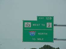
Route 113 begins as East Avenue at Route 2 (Bald Hill Road) in the East Natick section of Warwick, near the Rhode Island Mall. Past the mall, Route 113 crosses over the southern junction of Interstate 95 (I-95) and I-295. There is no access from Route 113 to northbound I-295. Soon after the 95/295 junction, Route 113 intersects with Route 5 (Greenwich Avenue) and continues eastward as Main Avenue. Route 113 then crosses over U.S. Route 1 (US 1) at a grade-separated intersection south of TF Green International Airport in the Greenwood neighborhood. Route 113 ends in Warwick center at Route 117 (West Shore Road).
History
Route 113 was assigned to its current routing by 1969.
Major intersections
The entire route is in Warwick, Kent County.
| mi[1] | km | Destinations | Notes | ||
|---|---|---|---|---|---|
| 0.0 | 0.0 | Western terminus | |||
| 0.5– 0.9 | 0.80– 1.4 | Exit 1A on I-295, exit 12 on I-95, no entrance to I-295 from Route 113 | |||
| 1.2 | 1.9 | ||||
| 2.1 | 3.4 | Southbound exit and northbound entrance from US 1 | |||
| 3.4 | 5.5 | Eastern terminus | |||
| 1.000 mi = 1.609 km; 1.000 km = 0.621 mi | |||||
References
- Google (December 29, 2013). "Route 113" (Map). Google Maps. Google. Retrieved December 29, 2013.
External links

- 2019 Highway Map, Rhode Island