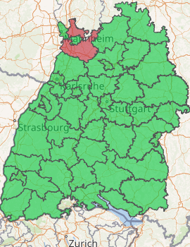
Rhein-Neckar-Kreis
Rhein-Neckar-Kreis is a Landkreis (district) in the northwest of Baden-Württemberg, Germany. Neighboring districts are Bergstraße, Odenwaldkreis, Neckar-Odenwald, Heilbronn, Karlsruhe, the independent city of Speyer, the Rhein-Pfalz-Kreis, and the independent cities of Mannheim and Heidelberg. The administrative headquarters are based in the city of Heidelberg, which does not form part of the district itself.
Rhein-Neckar-Kreis | |
|---|---|
| |
| Country | Germany |
| State | Baden-Württemberg |
| Adm. region | Karlsruhe |
| Capital | Heidelberg |
| Area | |
| • Total | 1,061.71 km2 (409.93 sq mi) |
| Population (31 December 2018)[1] | |
| • Total | 547,625 |
| • Density | 520/km2 (1,300/sq mi) |
| Time zone | UTC+01:00 (CET) |
| • Summer (DST) | UTC+02:00 (CEST) |
| Vehicle registration | HD |
| Website | http://www.rhein-neckar-kreis.de |
History
The district was created in 1973 by merging the previous districts of Heidelberg, Mannheim and a big part of Sinsheim.
Geography
It is named after the two main rivers which flow through the district, the Rhine and Neckar. The highest elevation is the Stiefelhöhe, near Heiligkreuzsteinach, with 583 m in the Odenwald mountains, the lowest elevation with 92 m is near Ilvesheim in the Neckar valley.
Government
The district is governed by a district assembly (Kreistag) and a district executive (Landrat). The eligible voters of the district elect the Kreistag every 5 years. This body in turn elects the Landrat every 8 years. The Landrat is the legal representative of the district as well as the speaker of the Kreistag and its committees. The Landrat manages the office of the Landrat (Landratsamt) and is the chief official of the district. The duties of the Landrat include the preparation of the district assembly meetings and its committees. The Landrat calls the meetings, acts as speaker, and carries out the decisions made. In the Kreistag, the Landrat has no vote. The Landrat has a second, called the first district official (Erste Landesbeamte).
Landrat of the district Heidelberg 1945–1972:
- 1945–1946: Hermann Specht (provisional)
- 1946–1947: Erich Reimann
- 1947–1954: Herbert Klotz
- 1954–1972: Georg Steinbrenner
Landrat of the district Mannheim 1945–1972:
- 1945: Richard Freudenberg (appointed)
- 1945–1946: Karl Geppert (appointed)
- 1946: Dr. Valentin Gaa (appointed)
- 1946–1948: Ernst Becherer
- 1948–1970: Dr. Valentin Gaa
- 1970–1972: Albert Neckenauer
Landrat of the district Sinsheim 1945–1972:
- 1945–1946: Roman Großmann (appointed)
- 1946: Gottlob Barth und Dr. Kurt von Kirchenheim (both appointed)
- 1946: Wolfgang Rutschke (appointed to oversee businesses)
- 1946–1947: Hermann Lindner (appointed)
- 1947–1948: Dr. Johann Gutermann
- 1948: Dr. Ludwig Bernheim
- 1948–1949: Georg Steinbrenner (appointed to oversee businesses)
- 1949–1950: Dr. Walther Reidel (appointed)
- 1950–1972: Dr. Paul Herrmann
Landrat of Rhein-Neckar-Kreis since 1973:
- 1973 Georg Steinbrenner, Amtsverweser
- 1973–1986: Albert Neckenauer
- 1986 to present: Dr. Jürgen Schütz
Coat of arms
 |
The wavy line in the left of the coat of arms represent the two rivers Rhine and Neckar. The lion in the right side is the symbol of Palatinate, as the area belonged to that area historically. |
Cities and towns
| Städte (Cities) | ||||
|---|---|---|---|---|
 |
 |
Eberbach | 15 258 | 81.2 km² |
 |
 |
Eppelheim | 14 629 | 5.6 km² |
 |
 |
Hemsbach | 12 230 | 12.9 km² |
 |
 |
Hockenheim | 21 031 | 34.8 km² |
 |
 |
Ladenburg | 11 473 | 19 km² |
 |
_COA.svg.png) |
Leimen | 26 932 | 20.6 km² |
 |
 |
Neckarbischofsheim | 3 946 | 26.4 km² |
 |
 |
Neckargemünd | 14 032 | 26.2 km² |
 |
 |
Rauenberg | 7 631 | 11.1 km² |
 |
.svg.png) |
Schönau | 4 696 | 22.5 km² |
 |
 |
Schriesheim | 14 855 | 31.6 km² |
 |
 |
Schwetzingen | 22 159 | 21.6 km² |
 |
 |
Sinsheim | 35 517 | 127 km² |
 |
 |
Waibstadt | 5 659 | 25.6 km² |
 |
_COA.svg.png) |
Walldorf | 14 774 | 19.9 km² |
 |
 |
Weinheim | 43 692 | 58.1 km² |
 |
 |
Wiesloch | 25 897 | 30.3 km² |
| Gemeinden (Municipalities) | ||||
 |
 |
Altlußheim | 5 296 | 16 km² |
 |
 |
Angelbachtal | 5 002 | 17.9 km² |
 |
 |
Bammental | 6 498 | 12.2 km² |
 |
 |
Brühl | 14 256 | 10.2 km² |
 |
 |
Dielheim | 8 933 | 22.7 km² |
 |
 |
Dossenheim | 12 008 | 14.1 km² |
 |
 |
Edingen-Neckarhausen | 14 127 | 12 km² |
 |
 |
Epfenbach | 2 517 | 13 km² |
 |
 |
Eschelbronn | 2 572 | 8.2 km² |
 |
 |
Gaiberg | 2 427 | 4.2 km² |
 |
 |
Heddesbach | 494 | 8.2 km² |
 |
 |
Heddesheim | 11 566 | 14.7 km² |
 |
 |
Heiligkreuzsteinach | 3 054 | 19.6 km² |
 |
 |
Helmstadt-Bargen | 3 793 | 28 km² |
 |
 |
Hirschberg an der Bergstraße | 9 405 | 12.4 km² |
 |
 |
Ilvesheim | 7 768 | 5.9 km² |
 |
 |
Ketsch | 12 808 | 16.5 km² |
 |
 |
Laudenbach | 6 110 | 10.3 km² |
 |
 |
Lobbach | 2 401 | 14.9 km² |
 |
 |
Malsch | 3 401 | 6.8 km² |
 |
 |
Mauer | 3 919 | 6.3 km² |
 |
 |
Meckesheim | 5 343 | 16.3 km² |
 |
_COA.svg.png) |
Mühlhausen (Kraichgau) | 8 218 | 15.3 km² |
 |
 |
Neidenstein | 1 820 | 8.5 km² |
 |
 |
Neulußheim | 6 675 | 3.4 km² |
 |
 |
Nußloch | 10 734 | 13.6 km² |
 |
 |
Oftersheim | 10 686 | 12.8 km² |
 |
 |
Plankstadt | 9 559 | 8.4 km² |
 |
 |
Reichartshausen | 2 015 | 10 km² |
 |
 |
Reilingen | 7 068 | 16.4 km² |
 |
 |
Sandhausen | 14 336 | 14.6 km² |
 |
_COA.svg.png) |
Schönbrunn | 2 987 | 34.5 km² |
 |
 |
Spechbach | 1 720 | 8.5 km² |
 |
 |
St. Leon-Rot | 12 539 | 25.6 km² |
 |
 |
Wiesenbach | 3 092 | 11.1 km² |
 |
 |
Wilhelmsfeld | 3 293 | 4.8 km² |
 |
 |
Zuzenhausen | 2 138 | 11.6 km² |
Sights
 |
Dilsberg | Bergfeste Dilsberg is a castle on a mountain over the Neckar River in Neckargemünd. |
 |
Eberbach | The historic old town with its four towers, many timber-frame houses and some town wall remnants, is a magnet for tourists. |
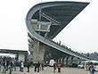 |
Hockenheim | The Hockenheimring is the home of the Formula One German Grand Prix. |
 |
Ladenburg | Ladenburg has an old town from the Late Middle Ages. Its history dates back to Celtic and Roman ages. |
 |
Neckargemünd | Neckargemünd still keeps its medieval charm. |
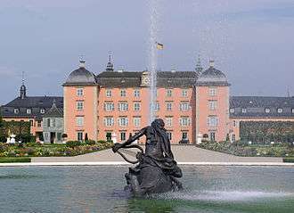 |
Schwetzingen | Schwetzingen Castle was the summer residence of the Electors Palatine Karl III Philip and Charles Theodore. |
.JPG) |
Sinsheim | Sinsheim's main tourist attraction is the Sinsheim Auto & Technik Museum, displaying a collection of historic vehicles to over 1 million visitors per year. |
 |
Weinheim | Weinheim is situated on the Bergstraße ("Mountain Road") on the western rim of the Odenwald. |
International relations
References
- "Bevölkerung nach Nationalität und Geschlecht am 31. Dezember 2018". Statistisches Landesamt Baden-Württemberg (in German). July 2019.
- "National Commission for Decentralised cooperation". Délégation pour l’Action Extérieure des Collectivités Territoriales (Ministère des Affaires étrangères) (in French). Archived from the original on 2013-10-04. Retrieved 2013-12-26.
External links
| Wikimedia Commons has media related to Rhein-Neckar-Kreis. |
- Official website (German)
| Authority control |
|
|---|