Rano
Rano is a Local Government Area and headquarters of Rano Emirate council in Kano State, Nigeria. Rano is a local government area in Kano State with administrative headquarters in the town of Rano. Rano local government area is a Hausa-Fulani community in the southern senatorial district of Kano State otherwise known as Kano South Senatorial District alongside Albasu, Bebeji, Bunkure, Doguwa, Gaya, Kiru, Takai, Ajingi, Rogo, Kibiya, Tudun Wada, Garko, Wudil and Sumaila local government areas. Rano local government area also forms a federal constituency alongside Bunkure and Kibiya local government areas. It has an area of 520 km² and a population of 145,439 at the 2006 census. The local government area is bounded to the north by Garun Mallam and Bunkure local government areas, to the east by Kibiya local government area, to the south by Tudun Wada local government area, and to the west by Bebeji local government area. The Rano local government council is in charge of public administration in Rano local government area. The council is led by a chairman who is the executive head of the local government. The Rano legislative council make laws governing Rano local government area. It consists of 10 Councillors representing the 10 wards of the local government area.
Rano Rauno | |
|---|---|
LGA and town | |
| Nickname(s): Autan Bawo | |
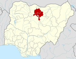
 Rano Location in Nigeria | |
| Coordinates: 11°33′26″N 8°35′00″E | |
| Country | |
| State | Kano State |
| Government | |
| • First Class Emir | Alhaji Kabiru Muhammad Inuwa |
| Area Rano, Kibiya, Bunkure, Bebeji, Kura, Kiru, Tudun-Wada, Doguwa, Sumaila, Takai | |
| • Total | 520 km2 (200 sq mi) |
| Population (2006 census) | |
| • Total | 145,439 |
| Time zone | UTC+1 (WAT) |
| 3-digit postal code prefix | 710 |
| ISO 3166 code | NG.KN.RA |
The 10 wards in Rano local government area are: Dawaki, Lausu, Madachi, Rano, Rurum Sabon Gari, Rurum Tsohon Gari, Saji, Yalwa, Zinyau, Zurgu.
postal code of the area is 710.[1]
History
THE HISTORY OF RANO DURING THE KWARARRAFA AND HABE DYNASTY (PRE-JIHAD PERIOD)
The history of Rano dated back to antiquity as its one of the oldest settlements in this part of Northern Nigeria, the kingdoms History started since 300 years before Christianity. The kingdom was fully established in the year 523AD by Kwararrafa warriors. The Kingdom witnessed three ruling dynasties as: - Kwararrafawa Ruled from 523 AD to 1001 AD, while Habe Ruled from 1001AD – 1819AD, then the Fulani's dynasty ruled from 1819 to date. As an autonomous kingdom in its own right, well over 40 kings ruled Rano kingdom before the advent of colonial rule.
The boundaries of Rano Kingdoms during the era stated above is as follows: -
To the west Rano was bounded to Kofar Dan-Agundi Kano To the east Rano was bounded to Gaya Emirate To the west Rano was bounded to Zazzau, Kaduna state To the south Rano was bounded to Ningi, Bauchi state.
Government
Emirs
The sequence of Kwararrafawa and Habe kings of Rano and their years of ruling is stated below: -
- RANAU (ruled- 523AD)
- ZAMNA KOGO (ruled 1001 – 1074)
- SARKUKI (ruled 1074 – 1165)
- BUSHARA (ruled 1165 – 1262)
- ZAMNA KOGI (ruled 1262 – 1345)
- KASKO (ruled 1345 – 1448)
- BILKASIM (ruled1448 – 1503)
- NUHU (ruled 1503 – 1551)
- ALI HAYAKI (ruled 1551 – 1703)
- JATAU (ruled 1703 – 1819)
References
- "Post Offices- with map of LGA". NIPOST. Archived from the original on 2009-10-07. Retrieved 2009-10-20.
State capital: Kano | ||
| Local government areas |
|  |