Jaurasi
Jaurasi is a mountain range, situated between the middle of the Salt and Dwarahat assembly of Almora district of Uttarakhand. It is situated between Ramganga and Vinod rivers, which is about 6500 feet high. This mountain range extends from the confluence of Ramganga and Vinod rivers, from Kedar to the top of Dudhatoli. The area adjacent to this mountain range is also known as 'Jaurasi range[1]'. In this mountain range, there is Jaurasi, Gairkhet, Ghaniyal Pokhar, Asurgadhi, Daanu Than, Chaubatia, Garhwal Bunga, Jadapani, Durga Devi, Kaliya Linguna, Nagchulakhal and Phulang Mountain and it is absorbed in the thick forests of the Dudhaatoli. Connecting Its biggest feature is that it is situated on the combined boundary of three districts of Uttarakhand - Almora, Chamoli and Pauri. On one side there is Chaukhutiya, Masi, Ranikhet and on the other side is Deghat, Syaldey, Bhikiyasain and its upper side are Gairsain and Nagchulakhaal. The British made many rest houses for their stay here, from which only Jaurasi Dak Bangla is present and the maintenance is done by the state government. The Dak Bangla of Kelani has just been transformed into ruins, which are still only remains. Being located at the altitude, there is a huge shortage of water, which is also the main reason for the migrat from here. In order to meet this shortage of water, the government has approved the Asurgarhi Pumping Drinking Water Scheme from Ramganga river, which is also likely to boost tourism in the region.
Jaurasi | |
|---|---|
Jaurasi Range | |
 जौरासी का खूबसूरत दृश्य | |
| Country | |
| State | Uttrakhand |
| District | Almora |
| Time zone | UTC+5:30 (IST) |
| PIN | 263656 |
| Telephone Code | 05966 |
Political representation
- Vidhansabha Area - Jaurasi is in the midst of two legislative assemblies 1) Sult and 2) Dwarahat
- Vidhayak of Sult and Dwarahat Setra-
- Sult - Surendra Singh Jeena (B J P)
- Dwarahat - Mahesh Negi (B J P)
Villages of the Jaurasi area
- List of Villages from Gewad
Jaurasi, Jala, Fadika, Jaintha Malla, Jaintha Talla, Surna Rekhadi, Surna Gopalgaon, Surna Bagwalikhet, Taya Surna, Chhani, Dang, Bheltgaon, Khatyadi Malli, Khatyadi Buchali, Khatayadi Talli, Kaurali, Selipatali, Chamadgaon, Sartoli, Timilkhaal, Tanhla, Basauli, Aadigram Kanodiya, Aadigram Fulieriya, Malsakhet, Sukhalon, kotida, Seemar, Seema, Sumanteshwar, Rugdhayee, Bakhali, Aadigram Bangari, Mausibau Bakhali, Bohragaon, Sunoli, Kaugad, Kushgaon, haat, Agarmanral, Pasauli, Mainpuri, Basnal Gaon, Satigaon,, Lamkasuon, Sisodiya, Patharkhadi, Kakrakhat, Jayrambakhal, Jhayn Karchuli, Udalikhan, Parthola, Muskhan, Rotapani, Bangari Gaon, kwaripigaon, Mohan, Kaudhar, Sangaon, Maniya Dhahi, Jhlyakhat, Viramdyo, Aammadali etc.
- List of Villages from Chaukot
Jaurasi, Kunakhaal, Kaligad, Gwalbeena, Malla Kafaltana, Talla Kafaltana, Malla Saugada, Talla Saugada, Gwakheel, Malla Ghanyal, Tall Ghanyal, Bichala Ghanyal, Ghaniyal Palla, Mangru, Bagotiyachhana, Mahgyari, Kaljheepa Joshi, Kahadgaon, Tamadhon, Joshi Pachruwa, Agari Pachruwa, Bachuli Seema, Jithani Katta, Basiseema, Motatimila, selipatali, Kanarikhil, Mohali, Sunoli, Titari, Gurana, Dhauliyagajar, Lambseemar, Kelani, Bakhali, Chauna, Sanarbheeda, Upradi, Jaikhal, Sabolichhana, Sanskhet, Kulseera, Futikuhan etc.
Education and Health Services in Jaurasi
Aadarsh Inter Collage, Jaurasi located in Jaurasi town[2] was established in 1948. This school is counted among the oldest schools in Uttarakhand. The first science-side was started in the same school in Syaldey and Chaukhutia block. At present, about 465 students and girls in the school are taking their education.[3]
Scenic spots
Jaurasi Bhagwati Mandir- Bhagwati Temple is situated in the middle of Jaurasi and is built by Baba Omi. According to the tradition of the old people, this temple was constructed by Om Baba (now also known as Omi Baba). It was at that time that our country was divided into different princely states and at that time the statue of Bhagwati Mata was established here by Shri Daulat Singh Ji, the King of Gwalbina. Now every year, Jaurasi Mela is also organized on the Navami of Chaitra month every year.
Bhairav Mandir- Located 1.5 kilometers from Jaurasi. From here the Himalayan philosophy becomes very easy. There is also a rest house, settled by the British. The forest department has opened its office at this place and has converted the dak bungalow into a guest house. This is the only office of the forest department in both areas Salt and Dwarahaat. There is also a nursery of forest department. After Ramnagar, forest related problems of the entire area are settled by this office.
Asurgarhi Mandir The height of about 7,000 feet is the highest mountain in the Jaurasi region. From here, the philosophy of all four directions of the region becomes very easy. From here there are visually visible sightings of Nadeena (Gewar), Manila (Chaukot), Dudhatoli, Bugyal, Brahmdhungi and Himalayas. According to the aphorism, Pandavas were hidden during the time of the agyatvaas, now this place also known as Chaukhutiya, at that time it was Viratnagari and in the Asurgarhi, was the kingdom of Asur Kichak. There was a fierce battle on this place of Bhimsen and Kichak, who ended up after killing Kichak by Bhima in Nitayeerau (Rampaduka). Here, the local people have established Asur Mata's temple and changed its name to Asurgarhi temple. On the first day of the Bhadra Maas, there is also a fair every year on the day of Ghee Sakranti. The most important scheme of the Jaurasi region is to set up Asurgarhi Drinking Water Scheme[4] from Ramganga at this place.
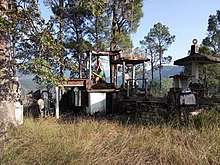
Fort of Kathuria king, Lakhanpur - Situated on the hill above the Udlikhan village of Lakhanpur Kot in Jaurasi range, which used to be the fort of the devoted rulers of Pali. It was also known as Asan-Basan singhasan at that time. It was the kingdom of Katyuri's king Asanti Basanti. His names can also be Basantdev and that of the King of Lalitsur Dev were among the children. There was a market called Kalirau-Haat near Lakhanpur, but now it is just a village here. The fort of Lakhanpur has now been transformed into ruins, the structures buried here are buried by the contractors in road construction. Many things of historical importance have been absorbed in the ground trough, the ruins of palaces and forts near the hill are still present. King Veeram Dev was the last ruler here. Above 200 meters of this fort and above the Haat village, Veeram Dev's Naala still remains and it is filled every time with water. At that time drinking water was supplied from these nullas. Here is the temple of Nursing Bhagwan, nine lakh Katyuri temple, Saraswati temple, Gayatri temple, Sheshawatar temple, Hanuman temple, Lakshman temple, 108 Shivling etc. Apart from this, there is a huge bell, yog sadhana room, katuri hammock and paradise ladder present here. From there, a tunnel was constructed for the bathing of the queens, the remains of which still exist.
Mrityunjay Mahadev Mandir: This mythological temple is situated on the combined border of Gwalbina and Kafaltana Gram Sabha. During excavation by locals, ancient rare sculptures and shivling were received here. After which the Shivalaya was established here by residents of both the Gram Sabha. Due to lack of road, here the information of this temple is limited to local residents.
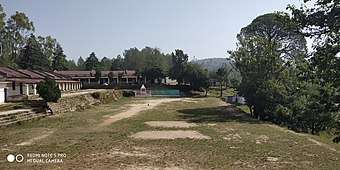
Image Gallary
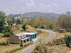
- View of Jaurasi
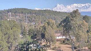 The Himalayas from Jaurasi
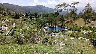 View of Chaukot from Jaurasi
 Danuthaan, Jaurasi Range
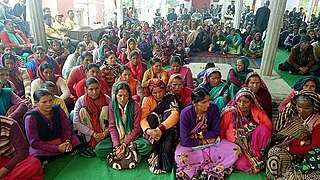 A seminar at Jaurasi Temple to stop migration from the area
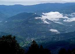
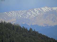 Bugyals (meadows) of Chamoli (as seen from Brahma-dhungi, Pauri Garhwal).
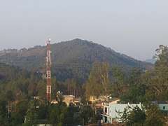 Asurgarhi temple, situated highest peak of the region
- असुरगढ़ी मंदिर (जौरासी) से नादीणा का खूबसूरत दृश्य
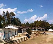 आदर्श राजकीय इंटर कॉलेज जौरासी
 जौरासी से ग्वालबीना ग्राम का दृश्य
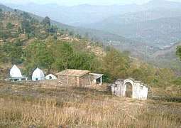 मृत्युंजय महादेव मंदिर