Randsburg, California
Randsburg (formerly, Rand Camp)[5] is a census-designated place (CDP) in Kern County, California, United States. Randsburg is located 17 miles (27 km) south of Ridgecrest,[5] at an elevation of 3,504 feet (1,068 m).[4] The population was 69 at the 2010 census, down from 77 at the 2000 census.
Randsburg | |
|---|---|
Census designated place | |
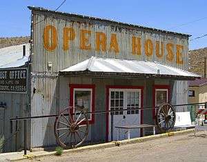 Randsburg Opera House | |
 Location in Kern County and the state of California | |
 Randsburg Location in the United States | |
| Coordinates: 35°22′07″N 117°39′29″W | |
| Country | |
| State | |
| County | Kern |
| Government | |
| • State senator | Shannon Grove (R)[1] |
| • Assemblymember | Vince Fong (R)[1] |
| • U. S. rep. | Kevin McCarthy (R)[2] |
| Area | |
| • Total | 1.945 sq mi (5.038 km2) |
| • Land | 1.906 sq mi (4.937 km2) |
| • Water | 0.039 sq mi (0.101 km2) 2% |
| Elevation | 3,504 ft (1,068 m) |
| Population | |
| • Total | 69 |
| • Density | 35/sq mi (14/km2) |
| Time zone | UTC-8 (Pacific) |
| • Summer (DST) | UTC-7 (PDT) |
| ZIP code | 93554 |
| Area codes | 442/760 |
| FIPS code | 06-59668 |
| GNIS feature ID | 1661284 |
Geography
Randsburg is located at 35°22′07″N 117°39′29″W.[4] It is on the west side of U.S. Route 395 between Kramer Junction to the south and Ridgecrest to the north. Randsburg is in the Rand Mountains, and is separated by a ridge from the neighboring community of Johannesburg.
According to the United States Census Bureau, the CDP has a total area of 1.945 square miles (5.038 km2), over 99% of it land.
History
.jpg)
The card game being played in the photograph is known as Faro. Faro was very popular from 1860 to about 1960. The last game of Faro vanished from Las Vegas from The Dunes hotel casino in about 1980.
Gold was discovered at Rand Mine near the site in 1895 and a mining camp quickly formed, and was named Rand Camp, both mine and camp were named after the gold mining region in South Africa.[5] The first post office at Randsburg opened in 1896.[5]
Tourism
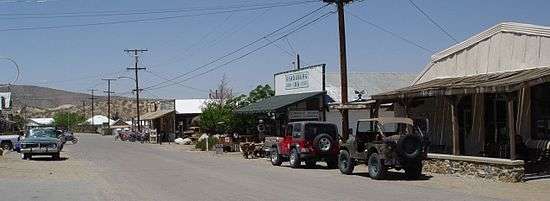
The town has an influx of tourism throughout the year. Most visitors arrive between Fall and Spring due to the extreme heat of the summer. The annual Western Days Celebration starts in the third weekend of September, where the town hosts events such as gun fights, panning for gold, live bands, dances, and vendors. During Thanksgiving and New Year's Day weekend, off-roading enthusiasts visit via the town's legal off-roading trail. Shops in town are usually closed for weekdays, only open during weekends for tourists.
Demographics
2010
At the 2010 census Randsburg had a population of 69. The population density was 35.5 people per square mile (13.7/km²). The racial makeup of Randsburg was 62 (89%) White, 0 African American, 4 (6%) Native American, 2 (3%) Asian, 0 Pacific Islander, 0 from other races, and 1 (1%) from two or more races. Hispanic or Latino of any race were 2 people (3%).[6]
The whole population lived in households, no one lived in non-institutionalized group quarters and no one was institutionalized. 0 lived in non-institutionalized group quarters, and 0 were institutionalized.
There were 42 households, 1 (2%) had children under the age of 18 living in them, 13 (31%) were opposite-sex married couples living together, 4 (10%) had a female householder with no husband present, 0 had a male householder with no wife present. There were 5 (12%) unmarried opposite-sex partnerships, and 3 (7%) same-sex married couples or partnerships. 17 households (41%) were one person and 6 (14%) had someone living alone who was 65 or older. The average household size was 1.6. There were 17 families (41% of households); the average family size was 2.1.
The age distribution was 2 people (3%) under the age of 18, 2 people (3%) aged 18 to 24, 5 people (7%) aged 25 to 44, 37 people (54%) aged 45 to 64, and 23 people (33%) who were 65 or older. The median age was 59.1 years. For every 100 females, there were 68.3 males. For every 100 females age 18 and over, there were 67.5 males.
There were 97 housing units at an average density of 49.9 per square mile, of the occupied units 39 (93%) were owner-occupied and 3 (7%) were rented.The homeowner vacancy rate was 2%; the rental vacancy rate was 50%. 64 people (93% of the population) lived in owner-occupied housing units and 5 people (7%) lived in rental housing units.
2000
At the 2000 census there were 77 people, 49 households, and 22 families in the CDP. The population density was 39.1 people per square mile (15.1/km²). There were 109 housing units at an average density of 55.4 per square mile (21.4/km²). The racial makeup of the CDP was 86% White, 5% Native American, 4% from other races, and 5% from two or more races. 5% of the population were Hispanic or Latino of any race.[7] Of the 49 households 4% had children under the age of 18 living with them, 43% were married couples living together, and 53% were non-families. 49% of households were one person and 25% were one person aged 65 or older. The average household size was 1.6 and the average family size was 2.1.
The age distribution was 4% under the age of 18, 3% from 18 to 24, 16% from 25 to 44, 48% from 45 to 64, and 30% 65 or older. The median age was 57 years. For every 100 females, there were 92.5 males. For every 100 females age 18 and over, there were 94.7 males.
The median household income was $48,000 and the median family income was $49,875. Males had a median income of $53,750 versus $21,250 for females. The per capita income for the CDP was $23,602. None of the population and none of the families were below the poverty line.
Film and video
South of Suez, starring George Brent and released in November 1940, was filmed in Randsburg.[8]
The video for Calvin Harris's platinum single, Feel So Close, was filmed in part in Randsburg. Dwight Yoakam's 1989 video for "Long White Cadillac" was also filmed in the town.[9]
Episode 12 of the Creature Hub's 2014 series Road Trip to E3 featured the cast driving through the town of Randsburg while filming half of the event.[10]
References
- "Statewide Database". Regents of the University of California. Archived from the original on February 1, 2015. Retrieved April 6, 2015.
- "California's 23rd Congressional District - Representatives & District Map". Civic Impulse, LLC.
- "2010 Census U.S. Gazetteer Files – Places – California". United States Census Bureau.
- U.S. Geological Survey Geographic Names Information System: Randsburg, California
- Durham, David L. (1998). California's Geographic Names: A Gazetteer of Historic and Modern Names of the State. Clovis, Calif.: Word Dancer Press. p. 1094. ISBN 1-884995-14-4.
- "2010 Census Interactive Population Search: CA - Randsburg CDP". U.S. Census Bureau. Archived from the original on July 15, 2014. Retrieved July 12, 2014.
- "U.S. Census website". United States Census Bureau. Retrieved 2008-01-31.
- "South of Suez". IMDb.com. Retrieved 22 September 2018.
- "System Error - Meijer.com". Meijer.com. Retrieved 22 September 2018.
- "Where are we?! - Road to E3". YouTube. 2014-06-11. Retrieved 2016-05-02.
External links
| Wikimedia Commons has media related to Randsburg, California. |
- Randsburg photo gallery at Western Mining History

| Authority control |
|
|---|