Rakhiv
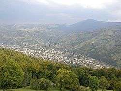
Rakhiv (Ukrainian: Рахів, pronounced [ˈrɑxiu̯]; Rusyn: Рахово; see below) is a city located in Zakarpattia Oblast (province) in western Ukraine. It is the administrative center of Rakhiv Raion (district). Population: 15,489 (2017 est.)[1].
Rakhiv | |
|---|---|
City of district significance | |
 | |
 Flag  Coat of arms | |
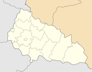 Rakhiv Location of Rakhiv | |
| Coordinates: 48°03′00″N 24°12′00″E | |
| Country | |
| Oblast | |
| Raion | Rakhiv Raion |
| Founded | 1477 |
| Incorporated | 1958 |
| Government | |
| • Mayor | Medvid, Viktor |
| Area | |
| • Total | 5.68 km2 (2.19 sq mi) |
| Elevation | 430 m (1,410 ft) |
| Population (2017) | |
| • Total | 15,489 (2,017 est.)[1] |
| Time zone | UTC+1 (CET) |
| • Summer (DST) | UTC+2 (CEST) |
| Postal code | 90600 |
| Area code(s) | +380-3132 |
| Climate | Dfb |
Names
There are several alternative names used for this city: Rusyn: Рахово; Hungarian: Rahó; Romanian: Rahău; Russian: Рахов, romanized: Rakhov; Yiddish: ראחוב, romanized: Rakhev or Rakhyv; Slovak: Rachov; German: Rachiw; Polish: Rachów.
Features
Rakhiv, or more precisely, the village Dilove located close to it, is one of several European locations vying for the symbolic right to be Geographical centre of Europe. The sign in Dilove, the point calculated in 1887 by the Austro-Hungarian geographers, carries a Latin inscription: "Locus Perennis Dilicentissime cum libella librationis quae est in Austria et Hungaria confectacum mensura gradum meridionalium et paralleloumierum Europeum. MD CCC LXXXVII."
There was Thomas Garrigue Masaryk in his stay to study a situation on the Romanian front during World War I in Hotel "Ukraina" on the winter 1917 - 1918, which remind the memorial desk there. [3]
The Headquarters of Carpathian Biosphere Reserve[4] are located in Rakhiv.
With an elevation of 430 meters above sea level, Rakhiv is Ukraine's highest city.
Climate
The climate in Rakhiv is a mild/cool summer subtype (Köppen: Dfb) of the humid continental climate.
| Climate data for Rakhiv | |||||||||||||
|---|---|---|---|---|---|---|---|---|---|---|---|---|---|
| Month | Jan | Feb | Mar | Apr | May | Jun | Jul | Aug | Sep | Oct | Nov | Dec | Year |
| Daily mean °C (°F) | −4.2 (24.4) |
−2.1 (28.2) |
2.6 (36.7) |
8.4 (47.1) |
13.4 (56.1) |
16.4 (61.5) |
17.9 (64.2) |
17.4 (63.3) |
13.7 (56.7) |
8.6 (47.5) |
3.0 (37.4) |
−1.6 (29.1) |
7.8 (46.0) |
| Average precipitation mm (inches) | 44 (1.7) |
40 (1.6) |
40 (1.6) |
57 (2.2) |
83 (3.3) |
105 (4.1) |
94 (3.7) |
79 (3.1) |
51 (2.0) |
43 (1.7) |
49 (1.9) |
56 (2.2) |
741 (29.1) |
| Source: Climate-Data.org[5] | |||||||||||||
Twin town
People from Rakhiv
- Mickola Vorokhta, the Ukrainian artist was born here.
Gallery
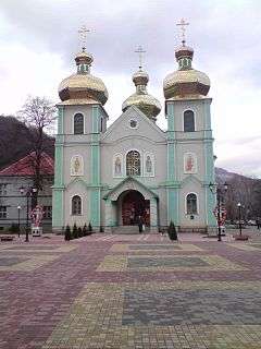
 Church of Saint John Nepomucene
 Hotel Europa in Rakhiv
 Hutsul festival in Rakhiv
References
- "Чисельність наявного населення України (Actual population of Ukraine)" (in Ukrainian). State Statistics Service of Ukraine. Retrieved 26 August 2017.
- Statistical Collection "Population of Ukraine" as of January 1, 2017 (PDF(zip)) (in Ukrainian)
- PRECLÍK, Vratislav. Masaryk a legie (Masaryk and legions), váz. kniha, 219 str., vydalo nakladatelství Paris Karviná, Žižkova 2379 (734 01 Karviná, CZ) ve spolupráci s Masarykovým demokratickým hnutím (Masaryk Democratic Movement, Prague), 2019, ISBN 978-80-87173-47-3, pp.17 - 25, 33 - 45, 70 – 96, 100- 140, 159 – 184, 187 - 199
- Carpathian Biosphere Reserve
- "Climate: Rakhiv". Climate-Data.org. Retrieved 1 May 2014.
External links

- Rakhiv Business Catalog - You'll find the latest information about hotels, cottages, recreation in Carpathians
- Rakhiv Travel Site
- City of Rakhiv Informational portal
- Rakhiv in the Encyclopedia of Ukraine
| Raions | |||||
|---|---|---|---|---|---|
| Hromadas | |||||
| Cities |
| ||||
| |||||
| Authority control |
|
|---|