Rajouri
Rajouri or Rajauri (/rəˈdʒɔːri/) is a town in Rajouri district in the union territory of Jammu and Kashmir, India. It is located about 155 kilometres (96 mi) from Srinagar and 150 km from Jammu city on the Poonch Highway. The town is the location of Baba Ghulam Shah Badshah University and the birthplace of Sikh General Banda Singh Bahadur.
Rajouri | |
|---|---|
Town | |
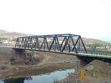
 View of old Jhula Bridge at Medina Colony, Rajouri. | |
 Rajouri Location in Jammu and Kashmir, India  Rajouri Rajouri (India) | |
| Coordinates: 33°23′N 74°18′E | |
| Country | India |
| Union territory | Jammu and Kashmir |
| District | Rajouri |
| Settled | 623 BC |
| Government | |
| • Type | Municipal Committee |
| • Body | Rajouri Municipal Committee |
| Elevation | 915 m (3,002 ft) |
| Population (2011) | |
| • Total | 41,552 (Including Kheora and Jawahar Nagar), 6,42,415 (in Rajouri district)[1] |
| Time zone | UTC+5:30 (IST) |
| Website | http://rajouri.nic.in/ |
History
Ancient History
The area of Rajouri principality included proper Rajouri, Thanna Mandi, Bagla Azim Garh, Behrote, Chingus, Darhal, Nagrota and Phalyana, etc.
Modern History
In 1813, Gulab Singh of Jammu captured Rajouri for the Sikh Empire of Maharaja Ranjit Singh, by defeating Raja Agar Ullah Khan.[2] After this, Rajouri became part of the Sikh Empire. But parts of it were given as jagirs to Rahim Ullah Khan (a half-brother of Agar Ullah Khan) and other parts to Gulab Singh.[3]
Following the First Anglo-Sikh War and the Treaty of Amritsar (1846), all the territories between the Ravi River and the Indus were transferred to Gulab Singh, and he was recognised as an independent Maharaja of Jammu and Kashmir. Thus Rajouri became a part of the princely state of Jammu and Kashmir.[4] Gulab Singh changed the name of Rajouri to Rampur. He appointed Mian Hathu as Governor of Rajouri, who remained in Rajouri up to 1856.[5] Mian Hathu constructed a stunning temple in between Thanna Nallah in close proximity to Rajouri city. He also built Rajouri Fort at Dhannidhar village.
After Mian Hathu, Rajouri was transformed into a tehsil and affiliated with Bhimber district. In 1904, this tehsil was separated from Bhimber and affiliated with the Reasi district.[4]
Partition
After the Partition of India and the accession of Jammu and Kashmir to India in October 1947, there followed the First Kashmir War between India and Pakistan. The Pakistani raiders, along with the rebels and deserters from the western districts of the state, captured Rajouri on 7 November 1947. The 30,000 Hindus and Sikhs living in Rajouri were reportedly killed, wounded or abducted.[6][7][8] Rajouri was recaptured on 12 April 1948 by the 19 Infantry Brigade of the Indian Army under the command of Second Lieutenant Rama Raghoba Rane. Rane, despite being wounded, launched a bold tank assault by conveying the tanks over the Tawi river bed in order to avoid the road blocks along the main road.[9] When the Indian Army entered the town, the captors had fled, having destroyed most of the town and killing all its inhabitants. After the arrival of the Army, some 1,500 refugees that had fled to the hills, including women and children, returned to the town.[10]
The ceasefire line at the end of the War ran to the west of the Rajouri-Reasi district.
Inside India
Soon after the war, the Rajouri and Reasi tehsils were separated. The Rajouri tehsil was merged with the Indian-administered Poonch district to form the Poonch-Rajouri district.[4] The Reasi tehsil was merged with the Udhampur district.
On 1 January 1968, the two tehsils were reunited and the resulting district was named the Rajouri district.[4]
The Reasi tehsil was also separated out in 2006 into a separate Reasi district. The present Rajouri district comprises the 1947 Rajouri tehsil.
Rajouri witnessed some of the toughest fighting during the Second Kashmir War in 1965. Pakistani infiltration in Kashmir during Operation Gibraltar caused Rajouri to be initially captured from the Indian Army by undercover Pakistani commandos with the aid of local Mujahideen. But the wider operation failed and, with all-out war with India looming, Pakistan withdrew its troops. Major Malik Munawar Khan Awan, a Pakistani commando officer who led the attack on Rajouri on the night of 15 September 1965, was later awarded the title "King of Rajouri" by the Government of Pakistan.[11]
Geography
Rajouri is located at 33.38°N 74.3°E.[12] It has an average elevation of 915 metres (3001 feet).
Climate
The climate of Rajouri is somewhat cooler than the other surrounding plains. Summers are short and pleasant. The summer temperature generally does not exceed 41 degrees. Winters are cool and chilly characterized with rainfall due to western disturbances. Snowfall is scanty but may occur in cool months like that of December 2012. Average rainfall is 769 millimetres (26.3 in) in the wettest months The average temperature of summer is 29'C and average temperature of winter is 16'C .[13]
Demographics
At the 2011 census,[14] Rajouri itself had a population of 37,552 while the population within the municipal limits was 41,552. Males constituted 57% of the population and females 43%. Rajouri had an average literacy rate of 77%, higher than the national average of 75.5%: male literacy was 83% and female literacy was 68%. 12% of the population was under 6 years of age. The people are mostly Gujjars and Paharis.
Muslims make up 55% of the population, Hindus 42% and Sikhs 2.4%.[15]
Population
| Type | Male | Female | Total |
|---|---|---|---|
| Rural | 3,10,748 | 2,79,353 | 5,90,101 |
| Urban | 34,603 | 17,711 | 52,314 |
| Total | 3,45,351 | 2,97,064 | 6,42,415 |
Households
| Rural | Urban | Total |
|---|---|---|
| 122,645 | 7,756 | 130,401 |
Transport
Air
Rajouri Airport is located 1 km from the town but currently is non-operational. The nearest airport to Rajouri is Jammu Airport which located 154 kilometres from Rajouri and is a 4 hr drive.
Rail
Rajouri doesn't have its own railway station. The nearest railway station to Rajouri is Jammu Tawi railway station which is located at a distance of 151 kilometres from the town and is a 4 hr drive. There are plans to connect Rajouri by rail through the Jammu–Poonch Railway Line in the near future.[16]
Road
Rajouri is well-connected by road to other towns, villages and cities of Jammu and Kashmir. The NH 144A passes through Rajouri.
References
- http://www.census2011.co.in/census/district/624-rajouri.html
- Panikkar, Gulab Singh 1930, p. 31.
- Panikkar, Gulab Singh 1930, p. 40.
- Sudhir S. Bloeria, Militancy in Rajouri and Poonch, South Asia Terrorism Portal, 2001.
- Bloeria, Sudhir S. (2000), Pakistan's Insurgency Vs India's Security: Tackling Militancy in Kashmir, Manas Publications, p. 37, ISBN 978-81-7049-116-3
- Prasad, Sri Nandan; Pal, Dharm (1 January 1987). Operations in Jammu & Kashmir, 1947-48. History Division, Ministry of Defence, Government of India. pp. 49–50.
- V. K. Singh, Leadership in the Indian Army 2005, p. 160.
- Ramachandran, Empire's First Soldiers 2008, p. 171.
- Rama Raghoba Rane received a Param Vir Chakra for his gallantry.
- Sarkar, Outstanding Victories of the Indian Army 2016, pp. 37–40.
- Niaz, Anjum (21 April 2013). "The 20-watt fountain of energy". Dawn.
- Falling Rain Genomics, Inc - Rajouri
- =IMD Archived 2012-03-15 at the Wayback Machine
- "Census of India 2001: Data from the 2001 Census, including cities, villages and towns (Provisional)". Census Commission of India. Archived from the original on 16 June 2004. Retrieved 1 November 2008.
- "Census of India — Administrative divisions". Censusindia.gov.in. Archived from the original on 13 November 2013. Retrieved 19 September 2011.
- "Centre nod to Jammu-Poonch rail line after several years". Daily Excelsior. Retrieved 24 December 2018.
Bibliography
- Panikkar, K. M. (1930), Gulab Singh, London: Martin Hopkinson Ltd
- Ramachandran, D. P. (2008), Empire's First Soldiers, Lancer Publishers, pp. 171–, ISBN 978-0-9796174-7-8
- Sarkar, Col. Bhaskar (2016), Outstanding Victories of the Indian Army, 1947-1971, Lancer Publishers, pp. 40–, ISBN 978-1-897829-73-8
- Singh, V. K. (2005), Leadership in the Indian Army: Biographies of Twelve Soldiers, SAGE Publications, pp. 160–, ISBN 978-0-7619-3322-9