Raivavae
Raivavae is one of the Austral Islands in French Polynesia. Its total land area including offshore islets is 17.9 km2 (6.9 sq mi).[1]:205 At the 2017 census it had a population of 903.[2] The island is of volcanic origin, and rises to 437 metres (1,434 ft) elevation at Mont Hiro.[1]:243
Raivavae | |
|---|---|
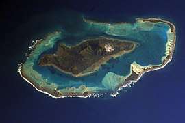 NASA picture of Raivavae island | |
 Flag | |
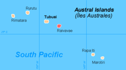 | |
Location of Raivavae 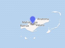
| |
| Coordinates: 23°52′09″S 147°39′49″W | |
| Country | France |
| Overseas collectivity | French Polynesia |
| Subdivision | Austral Islands |
| Area 1 | 17.9 km2 (6.9 sq mi) |
| Population (2017) | 903 |
| • Density | 50/km2 (130/sq mi) |
| Time zone | UTC−10:00 |
| INSEE/Postal code | 98739 /98750 |
| Elevation | 0–437 m (0–1,434 ft) |
| 1 French Land Register data, which excludes lakes, ponds, glaciers > 1 km2 (0.386 sq mi or 247 acres) and river estuaries. | |
History
Carbon-dating of archaeological remains allows settlement of these islands to be traced back to AD 1200–1450. The remains of some 100 marae platforms have been found on Ra`ivavae, at least 25 of them orientated to the rising and setting points of significant stars – a phenomenon potentially linked to the island's proximity to the Tropic of Capricorn. More than 60 huge stone tiki statues once stood on this island.[3] The first sighting by Europeans was recorded by the Spanish naval officer Tomás Gayangos on board of the frigate "El Aguila" on 5 February 1775. Gayangos had taken over the command of the expedition of Domingo de Bonechea of 1774 after his death in Tahiti and was returning to the Viceroyalty of Peru.[4] The main source describing this sighting is that of José Andía y Varela, pilot of the packet boat Jupiter that accompanied El Aguila in this return trip. On 6 February a boat was sent in, and made contact with the inhabitants at the shore edge, but landing was not made. Raivavae was charted as Santa Rosa by the Spaniards. The inhabitants said the name of their island was Oraibaba.[5][6][7]
It was annexed by France in 1880.
Administration
The islands of Raivavae are administratively within the commune with the same name. Raivavae consists of the following associated communes:[8]
See also
- Islands controlled by France in the Indian and Pacific oceans
References
- Environnement marin des îles Australes
- Répartition de la population en Polynésie française en 2017, Institut de la statistique de la Polynésie française
- Crowe, Andrew (2018). Pathway of the Birds: The Voyaging Achievements of Māori and their Polynesian Ancestors. Auckland, New Zealand: Bateman. pp. 46–49. ISBN 9781869539610.
- Salmond, Anne (2010). Aphrodite's Island. Berkeley: University of California Press. pp. 355. ISBN 9780520261143.
- Andía y Varela, José Relación del viaje hecho a la isla de Amat, por otro nombre Otahiti, y descubrimiento de las islas adyacentes en los años 1774 y 1775, Barcelona, 1947, p.83
- Sharp, Andrew The discovery of the Pacific Islands Oxford, 1960, p.126,127
- Corney, Bolton Granvill The quest and occupation of Tahiti by emissaries of Spain during the years 1772-1776, London, 1913, Vol I, p.XLVII
- Décret n°72-407 du 17 mai 1972 portant création de communes dans le territoire de la Polynésie française, Légifrance
| Wikimedia Commons has media related to Raivavae. |