Radbuza
The Radbuza (Czech pronunciation: [ˈradbuza]; German: Radbusa) is a river in the Czech Republic, the right source river of the Berounka. Its source is situated at the foot of Lysá mountain (869 metres) near the village of Závist, near Domažlice. It passes through the villages and towns of Rybník, Smolov, Bělá nad Radbuzou, Horšovský Týn, Staňkov, Holýšov, Stod, Chotěšov, Zbůch and Dobřany before joining the Mže in Plzeň, and as the Berounka eventually reaching the Vltava at Prague.
| Radbuza | |
|---|---|
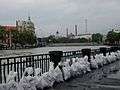
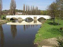 Radbuza in Dobřany | |
| Location | |
| Country | Czech Republic |
| Region | Plzeň |
| Physical characteristics | |
| Source | |
| • location | Bohemian Forest |
| • coordinates | 49°29′39.23″N 12°42′5.83″E |
| • elevation | 869 m (2,851 ft) |
| Mouth | Berounka |
• location | Plzeň |
| Length | 109.7 km (68.2 mi)[1] |
| Basin size | 2,190 km2 (850 sq mi) |
| Discharge | |
| • average | 11 m3/s (390 cu ft/s) |
| Basin features | |
| Tributaries | |
| • right | Úhlava |
| Progression | Berounka→ Vltava→ Elbe→ North Sea |
Its major tributaries are the Zubřina, Merklinka and Úhlava. It is 109.7 kilometres (68.2 mi) long, and its basin area is about 2,190 square kilometres (850 sq mi), of which 2,182 square kilometres (842 sq mi) in the Czech Republic.[2]
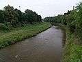
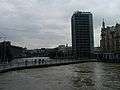
Gallery of the Radbuza
References
- Complete table of the Bavarian Waterbody Register by the Bavarian State Office for the Environment (xls, 10.3 MB)
- "Charakteristiky toků a povodí ČR - Radbuza" (in Czech). VÚV TGM. Retrieved 2018-05-08.
This article is issued from Wikipedia. The text is licensed under Creative Commons - Attribution - Sharealike. Additional terms may apply for the media files.