Berounka
The Berounka is a river in the Czech Republic, 138.2 km (85.9 mi) long,[1] the biggest left tributary of Vltava, draining an area of 8,708 km2 (3,362 sq mi). It carries the name Mže (German: Mies) for 105.2 kilometres (65.4 mi)[1] from its source in Germany, next to the Czech border, until its confluence with the 109.7-kilometre (68.2 mi)[1] Radbuza in Pilsen. It then continues with the name of Berounka until it enters the Vltava on the edge of Prague. Originally, the entire stream was called Mže, but in the 17th century the lower course started to be named after the town Beroun, lying upon it.
| Berounka Mže | |
|---|---|
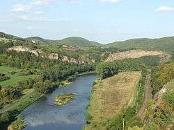 The Berounka under Tetín | |
_-_location_map.svg.png) 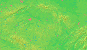 The Berounka with its two sources the Mže (northern) and the Radbuza (southern) until its confluence with the Vltava (magenta), also showing its watershed | |
| Location | |
| Country | Czech Republic |
| Cities | Tachov, Stříbro, Plzeň, Beroun, Prague |
| Physical characteristics | |
| Source | Mže |
| ⁃ location | Griesbacher Wald, Germany |
| ⁃ coordinates | 49°51′10″N 12°28′00″E |
| ⁃ elevation | 726 m (2,382 ft) |
| 2nd source | Radbuza |
| ⁃ location | Czech Republic |
| ⁃ coordinates | 49°29′13″N 12°39′58″E |
| ⁃ elevation | 869 m (2,851 ft) |
| Source confluence | Pilsen |
| Mouth | Vltava |
⁃ location | Prague |
⁃ coordinates | 49°59′43″N 14°24′05″E |
| Length | 138.2 km (85.9 mi)[1] |
| Basin size | 8,708 km2 (3,362 sq mi) |
| Discharge | |
| ⁃ location | mouth |
| ⁃ average | 36 m3/s (1,300 cu ft/s) |
| Basin features | |
| Progression | Vltava→ Elbe→ North Sea |
The river is a favourite destination among canoeists, who enjoy the picturesque sceneries around, especially when it flows along the Křivoklátsko Landscape Protected Area where three castle ruins tower over the Berounka river valley.

References
- Complete table of the Bavarian Waterbody Register by the Bavarian State Office for the Environment (xls, 10.3 MB)