Gangshiqia Peak
Gangshiqia Peak (simplified Chinese: 岗什卡雪峰; traditional Chinese: 崗什卡雪峰; pinyin: gǎngshíqiǎ xuěfēng; lit.: 'Ganshiqia Snow Peak') is a 5,254 m (17,238 ft) high mountain peak in the eastern Qilian Mountains of northeastern Qinghai province.[1] The mountain is located within Menyuan Hui Autonomous County of Haibei Prefecture, and is not far from the Gansu border. Ganshiqia is the highest peak in the Lenglong Ling (subrange) of the Qilian Mountains. Its southern slopes are drained by the Datong River and tributaries, while its northern slopes are drained by the Dongda He, an endorheic river terminating in Gansu near Jinchang.[2]
| Gangshiqia Peak | |
|---|---|
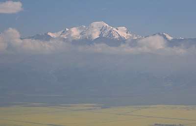 Mountain view from south above the rapeseed fields of Datong River Valley | |
| Highest point | |
| Elevation | 5,254 m (17,238 ft) |
| Prominence | 1,504 m (4,934 ft) |
| Coordinates | 37°41′36″N 101°30′18″E |
| Geography | |
 Gangshiqia Peak Location within Qinghai | |
| Location | Menyuan Hui Autonomous County, Qinghai, China |
| Parent range | Qilian Mountains |

The mountain possesses a popular climbing route via its glaciers, although Menyuan County is closed to foreigners without a permit. The nearest town is Qingshiju (青石咀镇), alternately Qingshizui (青石嘴),[3] in Menyuan County.[4]
References
- "Lenglong Ling High Point - Peakbagger.com". peakbagger.com. Retrieved 2017-03-02.
- Atlas of China. Beijing: SinoMaps Press. 2006. ISBN 9787503141782.
- 青石咀镇人民政府 - 高德地图 (in Chinese). Amap. Retrieved 2020-05-13.
See "青石嘴镇" or "青石嘴汽车站" in faint print
- "Gangshika : Climbing, Hiking & Mountaineering : SummitPost". summitpost.org. Retrieved 2020-05-13.