Puslinch, Ontario
Puslinch is a township in south-central Ontario, Canada, in Wellington County, surrounding the south end of Guelph. The main source of production is agricultural, spring water bottling and mining. Aggregate mining has been dominant throughout the county.[2] About half of the township is forested, and a conservation area lies to the southwest. Near the western edge of the township, just outside Cambridge, Ontario is Puslinch Lake, the largest kettle lake in North America. It is part of the Guelph census metropolitan area.
Puslinch | |
|---|---|
| Township of Puslinch | |
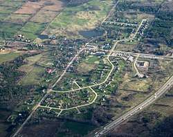 Morriston | |
 Coat of arms | |
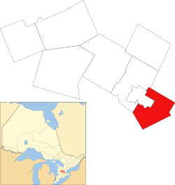 Location of Puslinch within Wellington County | |
 Puslinch Location of Puslinch within Wellington County | |
| Coordinates: 43°27′N 80°10′W | |
| Country | |
| Province | |
| County | Wellington |
| Incorporated | January 1, 1850 |
| Government | |
| • Type | Township |
| • Mayor | James Seeley |
| • Governing Body | Township of Puslinch Council |
| • MP | Mike Chong (Con) |
| • MPP | Ted Arnott (PC) |
| Area | |
| • Land | 214.62 km2 (82.87 sq mi) |
| Population (2016)[1] | |
| • Total | 7,336 |
| • Density | 34.2/km2 (89/sq mi) |
| Time zone | UTC-5 (EST) |
| • Summer (DST) | UTC-4 (EDT) |
| Postal Code FSA | N0B |
| Area code(s) | 519, 226 and 905 |
| Website | www.puslinch.ca |
The township has its own Strategic Plan, with the current version dated 2015 to 2020. Its mission statement is as follows: "Progressing together to provide reliable and sustainable services to our residents, businesses and visitors. We will protect our resources while respectfully building upon our heritage as a safe, fun and prosperous rural community."[3]
Communities

The township includes the communities of Aberfoyle, Aikensville, Arkell, Badenoch, Barbers Beach, Paddocks Corner, Corwhin, Crieff, Killean, Little Lake, Morriston and Puslinch.
Aberfoyle

Aberfoyle is the administrative centre for Puslinch Township and is home to the municipality's administrative offices, and fire station. It is located at the headwaters of Mill Creek, approximately three kilometres south of Guelph city limits on Brock Road, formerly a portion of old Hwy 6. Aberfoyle was first settled in the 1840s and is named for Aberfoyle, Scotland. In 1869, the population was only 100.[4]
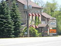
It is known for its spring water Aberfoyle Spring Water, which is bottled from Aberfoyle. Nestlé bought the company in 2002, through its subsidiary Nestlé Waters North America. Other features include Aberfoyle Public School[5] and the Aberfoyle Mill, a restaurant.[6]
Arkell
Arkell, pronounced "AR-kull", has a long relationship with beer brewing. Arkell was founded in 1830 by John Arkell, an Englishman who returned to the UK and founded Arkell's Brewery.[7] Just north and east of the village runs the Arkell Spring Aquifer, renowned for its fresh spring water which has brought many beverage companies to the area, including Sleeman Breweries, Wellington Brewery, and F&M Brewery. Wellington Breweries named one of their beers 'Arkell Best Bitter' in honour of the prized water they use in their brewing.[8] The Arkell Springs also provide some of the municipal water for the city of Guelph.[9]
Arkell is a common stopping point for cyclists and hikers to take a break when touring the country-side roads the surrounding city of Guelph, or the hiking trails at the Starkey Hill loop just east of the village, or the Arkell Springs trail which stretches along the Eramosa River from Watson Rd. Just north of Arkell, east to nearby Eden Mills near the Eden Mills outdoor education centre and south-east to Arkell Rd. at the Nassagaweya-Puslinch Townline Rd. intersection, opened in 1974 by the Guelph Hiking Club.[10]
History

Before colonization, the area was a "neutral" zone and was inhabited by the Neutral Nation, in a village of 4,000 in what is now the Badenoch area of Puslinch, near Morriston.[11]
The township was named after Puslinch House in Devon, England, where Elizabeth Yonge, the wife of Lieutenant Governor of Upper Canada Sir John Colborne, was born. The name was given by Lady Seaton after her birthplace in Devon, England. Sir John would later be the Lieutenant-Governor of Ontario from 1828 to 1836.[12] An historical plaque indicates that the township was surveyed in 1828-1832 by David Gibson and was originally known as the Church Lands.[13] Many people arrived in the 1830s via Stone Road from Dundas to Galt toward Killean in Puslinch.[14] A settler, Edward Ellis who arrived in 1839, donated land for the construction of the Wesleyan Methodist Church, also known as Ellis Chapel, in 1861.[15][16][17] Records from 1846 indicate a population in the township of 1500, most of whom were "Highland Scotch".[18]
The Arkell area was named after John Arkell (from an originally Dutch family) who emigrated from Kempsford, South Gloucestershire, arriving to the township in May 1831. He established the small community, but returned to England three years later. His first cousin Thomas Arkell remained, built a home, bred sheep and cattle, and was a Magistrate for three decades.[19][20] Henry Arkell, a breeder of sheep was heavily involved with the Puslinch Agricultural Society and was a Director of the Guelph Central Exhibition and the Fat Stock Show.[20]
The settlement of Aberfoyle was named by John McFarlane from Aberfoyle, Perthshire, Scotland who arrived in 1841 and ran the first general store. A small mill had been built earlier, in 1831, by George Schatz who built a sawmill and also laid out lots of land at a time when the area was called Schatzville, inhabited mostly by German families. Schatz also operated a foundry and brickyard over the years in the Aberfoyle area. The post office did not open until 1854 with Samuel Falconbridge the first postmaster. The first church, Mount Carmel, was built in 1877.[21]
Many of the Germans lived around Morriston, also part of Puslinch.[22] By 1857, Morriston had established the “Victoria Fire Company of the United Village of Morriston and Elgin” with a single fire wagon.[23] In that year, Morriston had a "daily male population of about 400".[24]
Demographics
| Puslinch, Ontario Historical populations | ||
|---|---|---|
| Year | Pop. | ±% |
| 1991 | 4,943 | — |
| 1996 | 5,416 | +9.6% |
| 2001 | 5,885 | +8.7% |
| 2006 | 6,689 | +13.7% |
| 2011 | 7,029 | +5.1% |
| 2016 | 7,336 | +4.4% |
| [25][26][1] | ||
Private dwellings occupied by usual residents: 2,705 (total dwellings: 2,793).[1]
Transportation
The main thoroughfares in the area include:
GO Bus Service
- GO Bus 29: to Mississauga (Square One GO Bus Terminal)
- GO Bus 48: to York University and Guelph University
- GO Bus 25 to Mississauga (Square One GO Bus Terminal), Milton, Cambridge, and Kitchener (Downtown, Wilfrid Laurier University, and University of Waterloo)
Attractions
- Starkey Hill Hiking Trail
- Puslinch Lake
- Antique Market
- Aberfoyle Mill Restaurant
- Aberfoyle Farmers Market
- Ellis Chapel
Notable residents
- John Idington, Supreme Court of Canada Justice
- Tommy Hunter, singer
- John Cullen, NHL centre
- Ryan Ellis, NHL defenseman
- Colleen McEdwards, CNN International anchor
- Justin Bieber, singer-songwriter[27]
Controversy
In December 2017, the township considered renaming Swastika Trail, a private road on the western edge of the township.[28] The road was initially named in the 1920s,[28] before the rise of Nazi Germany in 1933 (although Adolf Hitler's party adopted the hooked cross as the Nazi party symbol in 1920).[29] Residents on the street were divided by the name change, while the Jewish group B'nai Brith Canada supported it. The township ultimately decided not to rename the road, citing the previous decision of the cottager's association to leave the name in place.[30]
See also
References
- "Census Profile, 2016 Census: Puslinch, Township". Statistics Canada. Retrieved July 21, 2019.
- "Official Plan 5-Year Review – Aggregate Resources Mapping (PD2012-10)" (PDF). Wellington.ca. Retrieved 5 August 2018.
- "Community Based Strategic Plan : 2015 - 2020" (PDF). Pushlinch.ca. Retrieved 5 August 2018.
- McEvoy, Henry (August 1869). The Province of Ontario Gazetteer and Directory: Containing Concise Descriptions of Cities, Towns and Villages in the Province. Robertson & Cook. Retrieved August 5, 2018 – via Internet Archive.
- "Aberfoyle Public School Guelph Ontario Academic school ranking". Ontario.compareschoolrankings.org. Retrieved 5 August 2018.
- "Aberfoyle Mill Restaurant". Tripadvisor.ca. Retrieved July 21, 2019.
- "Our History". Arkell's Brewery Limited. Retrieved July 21, 2019.
- "Canada brews up good standings at beer awards". Torontosun.com. 10 August 2012. Retrieved August 5, 2018.
- "Arkell Spring Grounds". City of Guelph. Retrieved August 5, 2018.
- "History of Guelph Hiking Trail Club". Archived from the original on October 11, 2006.
- "The Attawandaron Discoveries - Museum of Ontario Archaeology". Archaeologymuseum.ca. June 10, 2016. Retrieved August 5, 2018.
- "Puslinch Township history-Annals of Puslinch 1850-1950". Clarksoftomfad.ca. Retrieved August 5, 2018.
- "Church Lands". Ellis Church: Enduring and Everlasting. Retrieved July 21, 2019.
- "Earliest History of Puslinch Lake: Backwoods Trails and Footpaths". Ellis Church: Enduring and Everlasting. Retrieved July 22, 2019.
- "The Building of Ellis Church 1859-1861". Ellis Church: Enduring and Everlasting. Retrieved July 22, 2019.
- "Settlement of Puslinch Historical Plaque". Ontarioplaques.com. Retrieved August 5, 2018.
- "Ellis Chapel 1861 and Cemetery - Abandoned Ontario". Ontarioabandonedplaces.com. Retrieved August 5, 2018.
- Smith, Wm. H. (1846). Smith's Canadian Gazetteer - Statistical and General Information Respecting all parts of The Upper Province, or Canada West. Toronto: H. & W. Rowsell. p. 155.
- "Puslinch Historical Society". Puslinchhistorical.ca. Retrieved August 5, 2018.
- "Pioneer - ARKELL, Thomas". Wellington County GenWeb. Retrieved July 22, 2019.
- KMJ, Quantum Slice Corporation. "Puslinch Historical Society". Puslinchhistorical.ca. Retrieved August 5, 2018.
- "Puslinch Historical Society". Puslinchhistorical.ca. Retrieved 5 August 2018.
- "Puslinch Township - History - Village of Morriston". Carksoftomfad.ca. Retrieved August 5, 2018.
- "1857 Morriston in the Canada Gazetteer". Ellis Church: Enduring and Everlasting. Retrieved July 22, 2019.
- Statistics Canada: 1996, 2001, 2006, 2011 census
- "Puslinch, Ontario (Code 3523001) census profile". 2011 Census of Population. Statistics Canada. Retrieved 2012-08-16.
- "Justin Bieber reportedly buys mansion in Puslinch Lake area | CTV News Kitchener". kitchener.ctvnews.ca. Retrieved 2018-12-12.
- Germano, Daniela (November 25, 2017). "Renaming Sought for 'Swastika Trail'". National Post. Postmedia.
- Boissoneault, Lorraine. "The Man Who Brought the Swastika to Germany, and How the Nazis Stole It". Smithsonianmag.com. Retrieved 5 August 2018.
- "Swastika Trail name appealed by Puslinch residents". CBC. 2018-04-12. Retrieved 12 May 2018.
31. "From Badenoch to Badenoch" History Scotland, Vol16, No 4, July/Aug 2016
External links
| Wikimedia Commons has media related to Puslinch, Ontario. |
- Township of Puslinch
- Wellington Guelph Community Portal
- Ontario Plaques - The Settlement of Puslinch
- Puslinch Lake Conservation Association
- Puslinch Today - Local News & Events
Places adjacent to Puslinch, Ontario | ||||||||||
|---|---|---|---|---|---|---|---|---|---|---|
| ||||||||||