Punta Bes
The Punta Bes is a 3,177[1] metres high mountain belonging to the Italian side of Graian Alps.
| Punta Bes | |
|---|---|
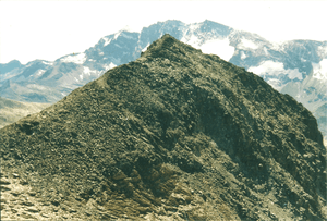 Punta Bes from Punta Leynir | |
| Highest point | |
| Elevation | 3,177 m (10,423 ft) [1] |
| Prominence | 65 m (213 ft) [2] |
| Parent peak | Punta Leynir |
| Coordinates | 45°30′43″N 7°08′16″E |
| Geography | |
 Punta Bes Location in the Alps | |
| Location | Piedmont/Aosta Valley, Italy |
| Parent range | Graian Alps |
| Climbing | |
| Easiest route | scrambling |
Geography
The mountain is located on the border between Piedmont and Aosta Valley, on the watershed dividing Valle dell'Orco from Valsavarenche, the latter tributary of the Dora Baltea. A 3.112 m high saddle[1] divides Punta bes from Punta Leynir, while the Orco/Valsavarenche ridge continues towards the Colle del Nivolet[3]. The Punta Bes, due to its location, offers a good view on the nearby massif of Gran Paradiso.
SOIUSA classification
According to SOIUSA (International Standardized Mountain Subdivision of the Alps) the mountain can be classified in the following way:[4]
- main part = Western Alps
- major sector = North Western Alps
- section = Graian Alps
- subsection = Central Graian Alps
- supergroup = Catena Grande Sassière-Tsanteleina
- group = Costiera Galisia-Entrelor-Bioula
- code = I/B-7.III-A.1
Access to the summit
The mountain can be accessed from Nivolet Pass (2.641 m); this route requires a good hiking experience[5]. Along with Punta Bes many hikers also climb the nearby Punta Leynir[6].
Mountain huts
- Refuge Città di Chivasso (2,604 m).
- Rifugio Albergo Savoia (2,534 m).
Nature protection
Punta Bes belongs to the Parco Nazionale del Gran Paradiso[3].
Maps
- Istituto Geografico Militare (IGM) official maps of Italy, 1:25.000 and 1:100.000 scale, on-line version
- Carta dei sentieri e dei rifugi scala 1:50.000 n. 3 Il Parco Nazionale del Gran Paradiso, Istituto Geografico Centrale - Torino
References
| Wikimedia Commons has media related to Punta Bes. |
- "Navigatore Cartografico SCT (3.14.0)". geonavsct.partout.it. Regione Autonoma Valle d'Aosta / Région autonome Vallée d'Aoste. Retrieved 2018-12-19.
- Key col:unnamed 3.112 m saddle between Punta Bes and Punta Leynir
- Carta dei sentieri e dei rifugi scala 1:50.000 n. 3 Il Parco Nazionale del Gran Paradiso, Istituto Geografico Centrale - Torino
- Marazzi, Sergio (2005). Atlante Orografico delle Alpi. SOIUSA (in Italian). Priuli & Verlucca. ISBN 978-88-8068-273-8.
- laika58 (2016-08-13). "Bes (Punte Nord e Sud) dai Piani del Nivolet per il Col Bes" (in Italian). Retrieved 2018-12-25.
- Berutto, Giulio (1979). "Punta del Leynir o Punta Vaudaletta". Il parco nazionale del Gran Paradiso (in Italian). 1. Istituto Geografico Centrale. pp. 168–169.