Puck County
Puck County (Polish: powiat pucki, Kashubian: pùcczi pòwiat) is a unit of territorial administration and local government (powiat) in Pomeranian Voivodeship, northern Poland, on the Baltic coast. The powiat of this name existed in the history of Poland, since the times of the Polish–Lithuanian Commonwealth up to 1795, and then reintroduced in 1999.
Puck County Powiat pucki | |
|---|---|
 Flag  Coat of arms | |
.svg.png) Division into gminas | |
| Coordinates (Puck): 54°42′N 18°24′E | |
| Country | |
| Voivodeship | Pomeranian |
| Seat | Puck |
| Gminas | Total 7 (incl. 4 urban)
|
| Area | |
| • Total | 577.85 km2 (223.11 sq mi) |
| Population (2006) | |
| • Total | 74,196 |
| • Density | 130/km2 (330/sq mi) |
| • Urban | 34,152 |
| • Rural | 40,044 |
| Car plates | GPU |
| Website | http://www.starostwo.puck.pl |
Modern Puck County
The modern Puck County came into being on January 1, 1999, as a result of the Polish local government reforms passed in 1998. Its administrative seat is the town of Puck, which lies 40 kilometres (25 mi) north of the regional capital Gdańsk. The county contains three other towns: Władysławowo, 16 km (10 mi) north of Puck, Jastarnia, 18 km (11 mi) east of Puck, and Hel, 29 km (18 mi) east of Puck, at the tip of the Hel Peninsula.
The county covers an area of 577.85 square kilometres (223.1 sq mi). As of 2006 its total population is 74,196, out of which the population of Władysławowo is 14,892, that of Puck is 11,329, that of Jastarnia is 4,033, that of Hel is 3,898, and the rural population is 40,044.
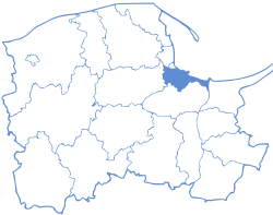
Puck County on a map of the counties of Pomeranian Voivodeship
Puck County is bordered by the city of Gdynia to the south and Wejherowo County to the south-west. It also borders the Bay of Puck to the east and the Baltic Sea to the north.
Administrative division
The county is subdivided into seven gminas (three urban, one urban-rural and three rural). These are listed in the following table, in descending order of population.
| Gmina | Type | Area (km²) |
Population (2006) |
Seat |
| Gmina Puck | rural | 243.3 | 21,868 | Puck * |
| Gmina Władysławowo | urban-rural | 38.4 | 14,892 | Władysławowo |
| Puck | urban | 4.9 | 11,329 | |
| Gmina Krokowa | rural | 211.8 | 10,089 | Krokowa |
| Gmina Kosakowo | rural | 47.4 | 8,087 | Kosakowo |
| Jastarnia | urban | 8.0 | 4,033 | |
| Hel | urban | 21.3 | 3,898 | |
| * seat not part of the gmina | ||||
Transport
Railway transport
The railway network in the area of this county consists of two active railway lines, 213 and dismantled 263. The lines intersected in Swarzewo. [1]
The station in Puck was located closest to the sea on the Polish railway network, which is why a temporary harbor with a railway siding was built in Puck. The development of railways in the county in the 1920s caused the development of tourism on Hel Spit. Because of the largely tourist traffic on Hel Spit, line 213 shows high seasonal variability of transports. Freight traffic, due to the lack of industry, is marginal.
References
- Stankiewicz, Stiasny, Ryszard, Marcin (2011). Mały atlas linii kolejowych Polski 2011. Rybnik: Eurosprinter. ISBN 978-83-931006-3-7.
| Urban gminas | | |
|---|---|---|
| Urban-rural gminas | ||
| Rural gminas | ||