Kościerzyna County
Kościerzyna County (Polish: powiat kościerski) is a unit of territorial administration and local government (powiat) in Pomeranian Voivodeship, northern Poland. It came into being on January 1, 1999, as a result of the Polish local government reforms passed in 1998. Its administrative seat and only town is Kościerzyna, which lies 51 kilometres (32 mi) south-west of the regional capital Gdańsk. Its borders equal approximately the borders of the old Marquessate of Berent in the German Empire.
Kościerzyna County Powiat kościerski | |
|---|---|
 Flag  Coat of arms | |
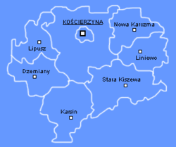 Division into gminas | |
| Coordinates (Kościerzyna): 54°7′N 17°59′E | |
| Country | |
| Voivodeship | Pomeranian |
| Seat | Kościerzyna |
| Gminas | |
| Area | |
| • Total | 1,165.85 km2 (450.14 sq mi) |
| Population (2006) | |
| • Total | 66,778 |
| • Density | 57/km2 (150/sq mi) |
| • Urban | 23,016 |
| • Rural | 43,762 |
| Car plates | GKS |
The county covers an area of 1,165.85 square kilometres (450.1 sq mi). As of 2006 its total population is 66,778, out of which the population of Kościerzyna is 23,016 and the rural population is 43,762.
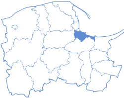
Kościerzyna County on a map of the counties of Pomeranian Voivodeship
Kościerzyna County is bordered by Kartuzy County to the north, Gdańsk County and Starogard County to the east, Chojnice County to the south, and Bytów County to the west.
History
Before the First Partition of the First Polish Republic in 1772, there was a non-town Kościerzyna County Council. During the Prussian partition in 1818-1919, the Prussian district "Landkreis Berent" functioned. In the years 1920-1939 (the Second Polish Republic) and 1945-1975 (PRL) there was a Kościerzyna Land District. In the period of September 1939 - February / March 1945, the area of the county was under German occupation.
In 1920, the county granted to Poland covered the area of 117,698 ha and was smaller than its Prussian counterpart of 6,301 ha, which left for the Free City of Gdańsk (villages of Częstocin, Trzepowo, Gromadzin, Czarna Huta, Borowina, Olszanka, Sucha Huta, and Pawłowo).[1]
Administrative division
The county is subdivided into eight gminas (one urban and seven rural). These are listed in the following table, in descending order of population.
| Gmina | Type | Area (km²) |
Population (2006) |
Seat |
| Kościerzyna | urban | 15.8 | 23,016 | |
| Gmina Kościerzyna | rural | 310.2 | 13,295 | Kościerzyna * |
| Gmina Nowa Karczma | rural | 113.3 | 6,288 | Nowa Karczma |
| Gmina Stara Kiszewa | rural | 213.1 | 6,267 | Stara Kiszewa |
| Gmina Karsin | rural | 169.2 | 5,905 | Karsin |
| Gmina Liniewo | rural | 110.1 | 4,561 | Liniewo |
| Gmina Dziemiany | rural | 125.0 | 4,065 | Dziemiany |
| Gmina Lipusz | rural | 109.2 | 3,381 | Lipusz |
| * seat not part of the gmina | ||||
References
- Franciszek Mamuszka, Izabella Trojanowska (1972). Kościerzyna i ziemia kościerska. Wydawnictwo Morskie.
| Seat |
| |
|---|---|---|
| Rural gminas | ||