Pray, Wisconsin
Pray is an unincorporated community located in the town of City Point, Jackson County, Wisconsin, United States.[1]
Pray, Wisconsin | |
|---|---|
 Pray  Pray | |
| Coordinates: 44°22′24″N 90°29′50″W | |
| Country | |
| State | |
| County | Jackson |
| Town | City Point |
| Elevation | 299 m (981 ft) |
| Time zone | UTC-6 (Central (CST)) |
| • Summer (DST) | UTC-5 (CDT) |
| Area code(s) | 715 & 534 |
| GNIS feature ID | 1571909[1] |
The community is named after Herman H. Pray (b. 1835). In 1877, Pray was appointed the local postmaster, and the office was named after him.[2][3]
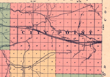
1914 map of town of City Point, showing locations of communities of City Point, Pray, and Spaulding.
The community is centered on the intersection of Pray Road and Old Highway 54 along the Green Bay and Western Railroad line, where it used to be a train stop. The community is located east of Waterbury and west of Spaulding along the rail line (also former rail stops),[4] and about 2.5 miles north of the current alignment of Wisconsin Highway 54,[5] which was completed in 1953.[6]
Notes
- "Pray, Wisconsin". Geographic Names Information System. United States Geological Survey.
- Moyer, Armond; Moyer, Winifred (1958). The origins of unusual place-names. Keystone Pub. Associates. p. 105.
- Biographical History of Clark and Jackson Counties, Wisconsin, p. 178 (1891)
- Specht, Ray and Ellen. The Story of Green Bay and Western (October 1966) (map lists Spaulding, Pray, and Waterbury as among "abandoned" stations on the line. Per this 1966 map, the nearest current stations on the line were Merrillan to the west and Wisconsin Rapids to the east)
- Soil Survey of Jackson County Wisconsin, p. 13 (1923)
- STH 54, Wisconsinhighways.com, Retrieved 12 November 2018
Municipalities and communities of Jackson County, Wisconsin, United States | ||
|---|---|---|
| City | 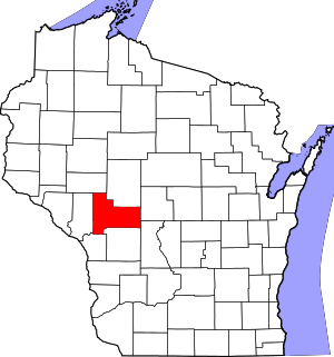 | |
| Villages | ||
| Towns | ||
| CDPs | ||
| Unincorporated communities | ||
| Ghost towns/neighborhoods | ||
| Indian reservation | ||
| Footnotes | ‡This populated place also has portions in an adjacent county or counties | |
This article is issued from Wikipedia. The text is licensed under Creative Commons - Attribution - Sharealike. Additional terms may apply for the media files.