Prague 17
Prague 17 is a municipal district (městská část) in Prague. It is located in the western part of the city. It is formed by one cadastre Řepy. As of 2008, there were 25,365 inhabitants living in Prague 17.
Prague 17 Praha 17 | |
|---|---|
Municipal District of Prague Administrative District of Prague | |
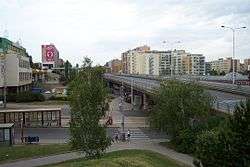 Řepy, Slánská street | |
 Flag  Coat of arms | |
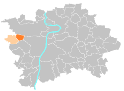 Location of Prague 17 in Prague | |
| Coordinates: 50°4′22″N 14°18′27″E | |
| Country | Czech Republic |
| Region | Prague |
| Government | |
| • Mayor | Jitka Synková |
| Area | |
| • Total | 3.26 km2 (1.26 sq mi) |
| Population (2008) | |
| • Total | 25,365 |
| • Density | 7,800/km2 (20,000/sq mi) |
| Time zone | UTC+1 (CET) |
| • Summer (DST) | UTC+2 (CEST) |
| Postal code | 163 00 |
| Website | http://www.repy.cz |
The administrative district (správní obvod) of the same name consists of municipal districts Prague 17 and Zličín.
External links
This article is issued from Wikipedia. The text is licensed under Creative Commons - Attribution - Sharealike. Additional terms may apply for the media files.