Cholupice
Cholupice (German: Cholupitz) a village in the south of Prague and a cadastral subdivision of Prague 12. There are 18 streets and 165 addresses registered, and a population of around 600. The Outer Ring Road passes just south of the village, and to the south-west there is a recreational airport. The Cholupice Cemetery lies to the east.
Cholupice | |
|---|---|
Cadastral subdivision of Prague 12 | |
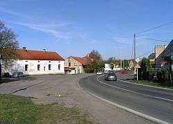 Village square | |
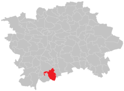 Location of Cholupice in Prague | |
| Coordinates: 49°59′12″N 14°26′55″E | |
| Country | Czech Republic |
| Region | Prague |
| Area | |
| • Total | 6.39 km2 (2.47 sq mi) |
| Population (31. 12. 2015[1]) | |
| • Total | 760 |
| • Density | 120/km2 (310/sq mi) |
| Time zone | UTC+1 (CET) |
| • Summer (DST) | UTC+2 (CEST) |
| Postal code | 143 00 |
Cholupice was, at one time, an independent municipality. The village of Točná was joined to Cholupice in 1960.[2] The municipality of Cholupice, including Točná, was amalgamated into the city of Prague in 1974. The local government in Cholupice was dissolved, and both villages were attached to the local government in Modřany,[3] which is now part of Prague 12.
Every year on April 30, near Ke Kálku street at the eastern end of the village, Cholupice hosts Prague's largest symbolic witch burning celebration. The village also has several clubs and community associations, including a volunteer fire brigade, a hunt club, an athletic club TJ Sokol Cholupice, a branch of the Czech Husbandry Asscociation Svaz Českých chovatelů, a horse-riding club and a fishing club. On a Saturday in the second half of May, the village hosts a traditional Welcoming of Spring celebration (Czech: vítání jara), including the raising of a maypole, and a parade through the village wearing folk costumes (Czech: kroj).
Photo gallery
 Podchýšská Street, towards Písnice
 Memorial to the fallen of World War I
 Lichá Street ("Odd Street") - there is no street in Prague named Sudá ("Even")
References
- "Obyvatelstvo a rozloha katastrálních území Prahy 2001–2015". Czech Statistical Office. 2016-06-08.
- M. Lašťovka, V. Ledvinka a kol.: Pražský uličník – Encyklopedie názvů pražských veřejných prostranství, 2. díl (O–Ž), Libri, Praha, 1998, p. 263, keyword „Točenská“
- Jan Mareš: Praha 12-Modřany, Kronika, volební období 1981–1985, MNV Praha-Modřany, chapter Vývoj zemědělství v Modřanech, source: Pamětní kniha MNV Točná
- This article was initially translated from the Czech Wikipedia.