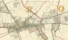
Port Laoise
Portlaoise (Pronounced /pɔːrtˈliːʃ/[2]), or Port Laoise (Irish [pˠɔɾˠt̪ˠˈl̪ˠiːʃə]) is the county town of County Laois, Ireland. It is located in the South Midlands in the province of Leinster. The 2016 census shows that the town's population increased by 9.5% to 22,050, which is well above the national average of 3.8%.[3] It is the most populous and also the most densely populated town in the Midlands Region, which has a total population of 292,301 at the 2016 census. [3] This also makes it the fastest growing of the top 20 largest towns and cities in Ireland.[3]
Portlaoise Port Laoise | |
|---|---|
 Main Street, Portlaoise | |
 Coat of arms | |
 Portlaoise  Portlaoise Portlaoise | |
| Coordinates: 53°1′51″N 7°18′3″W | |
| Country | Ireland |
| Province | Leinster |
| County | Laois |
| Founded | 1557 (as Maryborough) |
| Town Charter | 1570 |
| Government | |
| • Type | Laois County Council |
| • LEA | Portlaoise |
| • Dáil Éireann | |
| • European Parliament | Midlands–North-West |
| Area | |
| • Total | 12.1 km2 (4.7 sq mi) |
| Elevation | 139 m (456 ft) |
| Population (2016) | |
| • Total | 22,050 |
| • Rank | 16th (1st in Midlands) |
| • Density | 1,829.3/km2 (4,738/sq mi) |
| • Ethnicity[1] | Ethnic groups
|
| Time zone | UTC0 (WET) |
| • Summer (DST) | UTC+1 (IST) |
| Eircode | R32 |
| Area codes | 057, (+353)57 |
| Currency | Euro;(EUR:€) |
| Date Format | dd/mm/yyyy (AD) |
| Vehicle index mark code | LS |
| Drives on the | Left |
It was an important town in the medieval period, as the site of the Fort of Maryborough, a fort built by English settlers in the 16th century.
Portlaoise is fringed by the Slieve Bloom mountains to the west and north-west and the Great Heath of Maryborough to the east. It is notable for its architecture, engineering and transport connections. On the national road network, Portlaoise is located 94 km (58 mi) west-southwest from Dublin on the M7, 170 km (106 mi) north-east from Cork on the M8/M7 and 114 km (71 mi) east-northeast from Limerick on the M7.
It was once known for the manufacture of iron and steel buildings, tennis balls, rubber seals, tyres and electrical cabling. Today Portlaoise is a commercial centre, with the economy dominated by the service sector, and a hub of shopping, transport, and events for the surrounding catchment.
History

The site of the present town is referred to in the Annals of the Four Masters, written in the 1630s, as Port Laoighisi. The present town originated as a settlement around the old fort, "Fort of Leix" or "Fort Protector", the remains of which can still be seen in the town centre. Its construction began in 1548 under the supervision of the then Lord Deputy Sir Edward Bellingham, in an attempt to secure English control of the county following the exile of native Celtic chieftains the previous year. The fort's location on rising ground, surrounded to the south and east by the natural defensive barricades of the River Triogue and an esker known locally as 'the Ridge', greatly added to its strategic importance.
The town proper was established by an act of Parliament during the reign of Queen Mary in 1557. Though the early fort and its surrounding settlement had been known by a number of names, such as Governor, Port Laois, Campa and Fort Protector, the new town was named Maryborough (IPA [ˈmarbrə]) and the county was named Queen's County in Mary's honour. In about 1556, Port Laoise acquired its first parish church—Old St Peter's—situated to the west of Fort Protector. Although first built as a Catholic church, due to Queen Mary's re-establishment of Roman Catholicism, the church was used for Protestant services after the accession to the English throne of Mary's half-sister, Elizabeth.
The area had been a focus of the rebellion of Ruairí Óg Ó Mórdha, a local chieftain who had rebelled and had lost his lands, which the Crown wanted to be settled by reliable landowners. For the next fifty or so years, the new English settlers in Maryborough fought a continual, low-scale war with the Gaelic chieftains who fought against the new settlement. The town had been burnt several times by the end of the 16th century.
Port Laoise was granted a market in 1567, and then in 1570, a charter of Queen Elizabeth I raised the town to the rank of borough. This allowed the establishment of a Corporation of the Borough, a body which consisted of a burgomaster, two bailiffs, a town clerk, and a sergeant at arms, as well as various other officers, burgesses and freemen. Until the Act of Union took effect in 1801 and the abolition of its franchise, the town returned two members to the Irish Parliament. The Corporation itself existed until 1830.
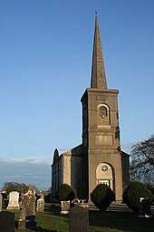
In 1803-04, a new Church of Ireland church was built to replace the Old St Peter's; it was the first building to be erected on the new Market Square. The building is attributed to architect James Gandon. Other notable buildings constructed in Port Laoise in the 19th century included the now-destroyed French Renaissance-style Town Hall on Market Square; the Court House on Main Street, built in 1805; the County Gaol built in 1830 to a design by William Deane Butler; and the neo-classical St. Fintan's Hospital, built in 1833 on the Dublin Road.
In 1929, a few years after the foundation of the Irish Free State, the town was renamed Portlaoighise (later simplified to Port Laoise) and the county was renamed County Laois.[4]
Local government

The town forms part of the Portlaoise Municipal District Local Electoral Area for elections to Laois County Council. This includes the urban Port Laoise area, Abbeyleix and Ballinakill and surrounding rural areas. Port Laoise's Town Council was abolished in 2014.
Port Laoise is twinned with Coulounieix-Chamiers in the Dordogne département of France.
Demography
| Historical population | ||
|---|---|---|
| Year | Pop. | ±% |
| 1821 | 2,677 | — |
| 1831 | 3,223 | +20.4% |
| 1841 | 3,633 | +12.7% |
| 1851 | 2,078 | −42.8% |
| 1861 | 2,935 | +41.2% |
| 1871 | 2,731 | −7.0% |
| 1881 | 2,872 | +5.2% |
| 1891 | 2,809 | −2.2% |
| 1901 | 2,957 | +5.3% |
| 1911 | 3,270 | +10.6% |
| 1926 | 3,374 | +3.2% |
| 1936 | 3,396 | +0.7% |
| 1946 | 3,170 | −6.7% |
| 1951 | 3,304 | +4.2% |
| 1956 | 5,561 | +68.3% |
| 1961 | 5,598 | +0.7% |
| 1966 | 5,873 | +4.9% |
| 1971 | 6,470 | +10.2% |
| 1981 | 7,756 | +19.9% |
| 1986 | 8,384 | +8.1% |
| 1991 | 8,360 | −0.3% |
| 1996 | 9,474 | +13.3% |
| 2002 | 12,127 | +28.0% |
| 2006 | 14,613 | +20.5% |
| 2011 | 20,145 | +37.9% |
| 2016 | 22,050 | +9.5% |
| [5][6][7][8][9] | ||
Portlaoise is one of Ireland's fastest growing towns, with a 37.9% increase in population from 2006 to 2011. Non-Irish nationals accounted for 21.7% of the population compared with a national average figure of 12.0%. Polish (7%) were the largest group, followed by Lithuanians (2.7%).[3] The former Mayor, Rotimi Adebari, was the first person of African descent to become a mayor in Ireland.[10]
Portlaoise has the highest percentage of people under the age of 18 in Ireland. Due to rapid population growth (due in particular to immigration from Eastern Europe, especially Poland and Slovakia) and its location in the commuter belt, Portlaoise has seen the development of additional services, including a new fire station and a large swimming leisure complex. Portlaoise has three new secondary schools and five new primary schools. In the 2016 Census Portlaoise was again in the top 10 fastest growing regions, with the population of Portlaoise town and its suburbs exceeding 22,000.
Economy
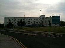
Portlaoise has long been a major commercial and retail hub for the Midlands. Until the mid 20th century, the main industries of the town were flour milling and the manufacture of worsted fabric. Since their respective declines, among the largest employers are state-owned bodies such as the maximum-security Port Laoise Prison, which houses the majority of the Irish Republican political prisoners sentenced in the Republic, the Midlands Prison, the Department of Agriculture and the Midland Regional Hospital, Portlaoise. State-owned companies Córas Iompair Éireann (railways, with a National Traincare Maintenance Depot in Portlaoise), the ESB (utilities, with a training centre in the town) and also An Post are all major employers. In 2013 MyPay, a new central payroll system for 55,000 local authority employees across Ireland, was set up in Portlaoise.[11]
Due to its location and transport connections, the National Spatial Strategy chose Portlaoise as the location for Ireland's first "Inland Port". This designation encourages the town to focus on the growth of distribution, logistics and warehouse uses. An Post operates the second largest mail centre in Ireland (after Dublin) at their depot in Portlaoise.[12]
Retail
Major retail spaces include Laois Shopping Centre, The Kyle Centre, Parkside Shopping Centre, Shaws department store and retail parks in Kea Lew and on the South Circular Road.
Tourism
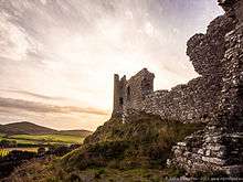
Tourist sites in the area include the Rock of Dunamase, a hill-top castle which dates from the 12th Century. There is also a 12th-century round tower 12km away in Timahoe.
Also close-by is Fort Protector, a 16th century fort built to protect British colonists from Irish natives.
Emo Court is a large Georgian estate designed by James Gandon at nearby Emo.
Transport
Portlaoise stands at a major crossroads in the Irish roads network (major roads to Dublin, Limerick, Cork) although construction in the 1990s of the M7 motorway, which bypasses the town, has reduced traffic congestion in the town centre.
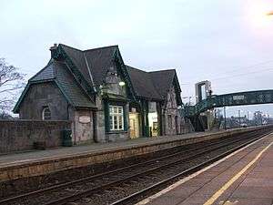
Port Laoise railway station is one the busiest railway stations outside of Dublin, and is served by intercity trains between Dublin and Cork and by Dublin commuter services. Maryborough railway station opened on 26 June 1847.[13] It is the terminus of the Portlaoise Commuter Service, which stops at all stations to Heuston and runs hourly off peak and every 20/30 minutes during peak times. It is the busiest county town railway station in the Midlands Region, with up to 32 trains to Dublin (10 non-stop) and 30 trains from Dublin (9 non-stop) per day.[14] Córas Iompair Éireann opened a rail depot south-west of Portlaoise town centre in March 2008, with a maintenance and servicing facility for the 183 new intercity railcars and some facilities for outer suburban railcars serving the Kildare route.
Bus Éireann operates an intercity service between Dublin and Cork/Limerick which calls at Port Laoise. The town is also the terminus for Dublin-Portlaoise coach services operated by Dublin Coach, which is at James Fintan Lawlor Avenue.
Culture and community
Nightlife
| Wikivoyage has a travel guide for Port Laoise. |
Portlaoise’s central location within Ireland and its concentration of restaurants, pubs, bars and nightclubs around Market Square, Main Street and the Church Street area of the town centre and other nearby facilities such as paintball, golf, bowling and other amenities make it a popular destination for hen & stag parties and other weekend breaks. Portlaoise railway station is the closest station to Stradbally Hall where the Electric Picnic Festival is held each year.
Arts and festivals
Every year the town hosts the Old Fort Quarter Festival in June, the Halloween Howls Comedy Festival on the October bank holiday weekend and the Leaves Literary Festival in November.
The Dunamaise Arts Centre which comprises a cinema, performance space and exhibition space is located in the building which formally housed the Maryborough Gaol. The opening of the Arts Centre in 1999 coincided with the revival of the Laois Drama Group.[15]
Charity
Since 2008, Port Laoise has been the Irish base of Self Help Africa, formerly Self Help Development International, a development agency engaged in implementing rural development programmes in Sub-Sahara. Established at the time of the Ethiopian Famine of 1984, the organisation is the chosen charity of the Irish Farmers Association.
Sport
Portlaoise RFC, a local rugby club, is based outside the town at Togher. Portlaoise GAA is the local Gaelic Athletic Association club and the most successful GAA club in Leinster. Other local sports clubs include Port Laoise Association Football Club and Portlaoise Senior Basketball Club.
Sporting facilities in the area include Port Laoise Leisure Centre (which has a 25m pool, a gym, astro and soccer pitches, and a skate park) and Portlaoise Golf Club (which has an 18-hole course on the Abbeyleix Road).
Portlaoise AFC located on the Mountmellick road in Rossleighan Park.
Education
Portlaoise College[16] is situated just minutes from the heart of Portlaoise. Portlaoise College provides full-time education for over 300 students in Junior and Leaving Certificate Cycle.
Portlaoise Institute[17] offers further education courses, including QQI Level 5 and 6 Courses. These include courses and professional certification in beauty therapy, hairdressing, healthcare, nursing, business studies, information technology, and sports and leisure management.
Notable people
- Arthur Jacob – Professor of Anatomy (Ophthalmologist)
- Sean O'Rourke – RTÉ journalist and broadcaster
- James Fitzmaurice – aviation pioneer
- Pat Critchley – GAA dual player (Footballer & All Star winner at Hurling)
- Pat Boran – poet and radio presenter
- Bartholomew Mosse – founder of the Rotunda Hospital, Dublin
- Stephen Hunt – association football player, was born in Port Laoise in 1981
- Pádraig Mac Lógáin – the only two-time President of Sinn Féin owned a pub on Main Street
- Robert Sheehan – actor (Misfits, Love/Hate, The Umbrella Academy).
- Zach Tuohy – Australian Football League player for the Geelong Football Club
- TJ Doheny - Professional Boxer, former IBF World Super Bantamweight Title holder.
- Brian Rigney - (born 22 September 1963) is an Irish former rugby union player who won 8 caps for his country between 1991 and 1992.
- Damien Bowe - singer and former member of Irish boyband D-Side.
- Anne Keenan-Buckley (1962-) - middle distance runner who was on the Irish 1988 Summer Olympics team.
- Eoghan Masterson – professional rugby player for Connacht
- Alison Miller – professional rugby player
References
- "Language". CSO.
- John Murray, Doireann Ní Bhriain (12 February 2014). Pronunciation. John Murray Show. RTÉ. Event occurs at 18m55s–19m45s.
- "Census of Population 2016 - Profile 2 Population Distribution and Movements". Central Statistics Office (Ireland). 2016.
- Port Laoise, Placenames Database of Ireland.
- Census for post 1821 figures.
- "HISTPOP.ORG - Home". www.histpop.org.
- "Archived copy". Archived from the original on 17 February 2012. Retrieved 17 February 2012.CS1 maint: archived copy as title (link)
- Lee, JJ (1981). "On the accuracy of the Pre-famine Irish censuses". In Goldstrom, J. M.; Clarkson, L. A. (eds.). Irish Population, Economy, and Society: Essays in Honour of the Late K. H. Connell. Oxford, England: Clarendon Press.
- Mokyr, Joel; O Grada, Cormac (November 1984). "New Developments in Irish Population History, 1700–1850". The Economic History Review. 37 (4): 473–488. doi:10.1111/j.1468-0289.1984.tb00344.x. hdl:10197/1406. Archived from the original on 4 December 2012.
- "Ireland elects first black mayor". BBC News. 28 June 2007. Retrieved 10 February 2017.
- "Minister Alan Kelly T.D. launches MyPay - payroll and superannuation shared service for local authorities - MerrionStreet". Merrionstreet.ie. 29 May 2015. Retrieved 6 November 2019.
- "Volume 3, Number 8 | Éire Philatelic Association". Eirephilatelicassoc.org. Retrieved 6 November 2019.
- "Maryborough station" (PDF). Railscot – Irish Railways. Retrieved 3 November 2007.
- "Grand Canal Dock to Portlaoise" (PDF). www.irishrail.ie. 20 November 2016. Archived from the original (PDF) on 1 March 2017. Retrieved 28 February 2017.
- Keating, Sara. "Cultural expansion, 10 years on". The Irish Times. Retrieved 24 January 2020.
- "Contact Portlaose College | Portlaoise College". www.portlaoisecollege.ie. Retrieved 27 February 2019.
- "Welcome to Portlaoise Institute of Further Education". www.portlaoiseinstitute.ie. Retrieved 27 February 2019.
External links
| Wikivoyage has a travel guide for Port Laoise. |
| Wikimedia Commons has media related to Portlaoise. |
Places in County Laois | ||
|---|---|---|
| Towns | 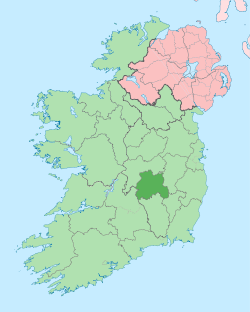 | |
| Villages and Townlands |
| |
| Landforms | ||
| ||
| Authority control |
|
|---|