Porsanger Peninsula
The Porsanger Peninsula (Norwegian: Porsangerhalvøya) is a peninsula in Troms og Finnmark county, Norway. The large peninsula sits between the Altafjorden and the Porsangerfjorden and includes parts of the municipalities of Alta, Hammerfest, Måsøy, Nordkapp, and Porsanger. Stabbursdalen National Park lies on the southern end of the peninsula.[1]
| Porsanger Peninsula | |
|---|---|
| Porsangerhalvøya | |
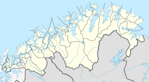 Porsanger Peninsula Location of the peninsula  Porsanger Peninsula Porsanger Peninsula (Norway) | |
| Location | Troms og Finnmark, Norway |
| Coordinates | 70.7560°N 25.0671°E |
The landscape of the Porsanger peninsula consists mainly of a treeless plain, a continuation of the Finnmarksvidda plateau to the south. A number of fjords cut into the peninsula, of which the largest are the Repparfjorden, Revsbotn, and Snefjorden from the west and the Kobbefjorden from the north. The European route E06 highway runs north through the peninsula.
This article is issued from Wikipedia. The text is licensed under Creative Commons - Attribution - Sharealike. Additional terms may apply for the media files.