Podgórze Duchackie
Podgórze Duchackie is one of 18 districts of Kraków, located in the southern part of the city. The name Podgórze Duchackie comes from two villages that are now parts of the district.
Podgórze Duchackie | |
|---|---|
 Bonarka City Center | |
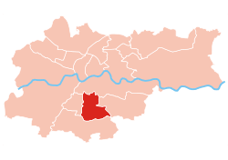 Location of Podgórze Duchackie within Kraków | |
| Coordinates: 50°0′44.2″N 19°57′50.65″E | |
| Country | |
| Voivodeship | Lesser Poland |
| County/City | Kraków |
| Government | |
| • President | Krzysztof Sułowski |
| Area | |
| • Total | 9.54 km2 (3.68 sq mi) |
| Population (2014) | |
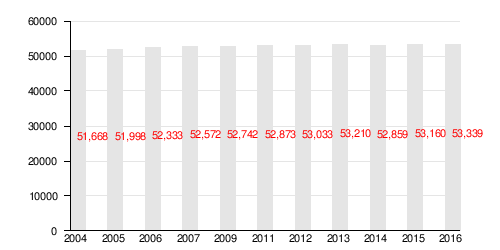
| • Total | 52,859 |
| • Density | 5,500/km2 (14,000/sq mi) |
| Time zone | UTC+1 (CET) |
| • Summer (DST) | UTC+2 (CEST) |
| Area code(s) | +48 12 |
| Website | http://www.dzielnica11.krakow.pl |
According to the Central Statistical Office data, the district's area is 9.54 square kilometres (3.68 square miles) and 52 859 people inhabit Podgórze Duchackie.[1]
Subdivisions of Podgórze Duchackie
Podgórze Duchackie is divided into smaller subdivisions (osiedles). Here's a list of them.
- Kurdwanów
- Kurdwanów Nowy
- Osiedle Piaski Nowe
- Osiedle Podlesie
- Piaski Wielkie
- Wola Duchacka
- Wola Duchacka Wschód
- Wola Duchacka Zachód
Population
References
- "Information about Podgórze Duchackie district". Biuletyn Informacji Publicznej. Retrieved 30 August 2017.
External links
| Wikimedia Commons has media related to District XI Podgórze Duchackie (Kraków). |
This article is issued from Wikipedia. The text is licensed under Creative Commons - Attribution - Sharealike. Additional terms may apply for the media files.