Łagiewniki-Borek Fałęcki
Łagiewniki-Borek Fałęcki is one of 18 districts of Kraków, located in the southern part of the city. The name Łagiewniki-Borek Fałęcki comes from two villages that are now parts of the district.
Łagiewniki-Borek Fałęcki | |
|---|---|
.jpg) | |
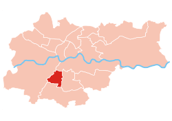 Location of Łagiewniki-Borek Fałęcki within Kraków | |
| Coordinates: 50°0′59.3″N 19°55′15.9″E | |
| Country | |
| Voivodeship | Lesser Poland |
| County/City | Kraków |
| Government | |
| • President | Jan Pietras |
| Area | |
| • Total | 5.42 km2 (2.09 sq mi) |
| Population (2014) | |
| • Total | 14,859 |
| • Density | 2,700/km2 (7,100/sq mi) |
| Time zone | UTC+1 (CET) |
| • Summer (DST) | UTC+2 (CEST) |
| Area code(s) | +48 12 |
| Website | http://www.dzielnica9.krakow.pl |
| Part of a series on the |
| Divine Mercy |
|---|
 The image by Kazimirowski |
| Forms |
| People |
| Places |
| Other |
|
According to the Central Statistical Office data, the district's area is 5.42 square kilometres (2.09 square miles) and 14 859 people inhabit Łagiewniki-Borek Fałęcki.[1]
Subdivisions of Łagiewniki-Borek Fałęcki
Łagiewniki-Borek Fałęcki is divided into smaller subdivisions (osiedles). Here's a list of them.
- Borek Fałęcki
- Łagiewniki
- Osiedle Cegielniana
- Osiedle Zaułek Jugowicki
Population

References
- "Information about Łagiewniki-Borek Fałęcki district". Biuletyn Informacji Publicznej. Retrieved 30 August 2017.
External links
| Wikimedia Commons has media related to District IX Łagiewniki-Borek Fałęcki (Kraków). |
This article is issued from Wikipedia. The text is licensed under Creative Commons - Attribution - Sharealike. Additional terms may apply for the media files.