Piney Run (Virginia)
Piney Run is a tributary of the Potomac River in Loudoun County, Virginia. The creek is the principle drainage of the upper Between the Hills valley in northwestern Loudoun County.
| Piney Run | |
|---|---|
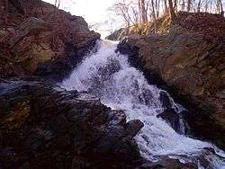 Falls of Piney Run | |
| Location | |
| Country | United States |
| State | Virginia |
| Region | Loudoun County |
| Physical characteristics | |
| Source | |
| ⁃ location | Neersville |
| ⁃ coordinates | 39.24°N 77.74°W |
| ⁃ elevation | 650 ft (200 m) |
| Mouth | Potomac River |
⁃ location | Loudoun Heights |
⁃ coordinates | 39.32°N 77.71°W |
⁃ elevation | 240 ft (73 m) |
| Length | 9 mi (14 km) |
| Basin size | 15.2 sq mi (39 km2) |
| Basin features | |
| Tributaries | |
| ⁃ left | Sweet Run |
The headwaters of the creek are located approximately 1.75 miles (2.82 km) south of Neersville, Virginia, just west of State Route 671 (Harpers Ferry Road). Just prior to an impoundment, 5 miles (8.0 km) from its headwaters on the property of the Blue Ridge Center for Environmental Stewardship, the creek is joined by its only named tributary branch, Sweet Run. From the impoundment, the creek flows 2 miles (3.2 km), to the crossing by State Route 671, whereupon the creek cuts a deep gorge, falling 150 feet (46 m) over its last 2 miles (3.2 km). Just prior to its confluence with the Potomac below the White Horse Rapids, 4,500 feet (1,400 m) down river from the confluence with the Shenandoah River, the creek passes through a culvert under U.S. Route 340 and then cascades approximately 20 feet (6.1 m) over a waterfall, the only in Loudoun County.