Aquia Creek
Aquia Creek ( /ɑːˈkwaɪə/) is a 27.6-mile-long (44.4 km)[1] tributary of the tidal segment of the Potomac River and is located in northern Virginia. The creek's headwaters lie in southeastern Fauquier County, and it empties into the Potomac at Brent Point in Stafford County, 45 miles (72 km) south of Washington, D.C.
| Aquia Creek | |
|---|---|
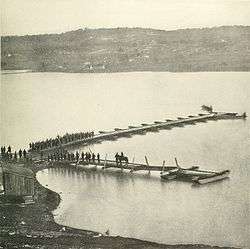 Aquia Creek Landing in Union control in February 1863. This position swapped hands between the two armies during 1861 and 1862, until the Union established a logistical supply point here for the Army of the Potomac. | |
| Location | |
| Location | Fauquier and Stafford counties, Virginia, US |
| Physical characteristics | |
| Mouth | |
• location | Potomac River |
• elevation | 0 feet (0 m) |
| Length | 27.6 miles (44.4 km) |
History
The Public Quarry at Government Island in the creek served as the source for Aquia Creek sandstone. This sandstone was used in numerous public buildings; the National Capitol Columns were quarried in the early 1800s, and transported to Washington on a barge.[2]
In an early American Civil War skirmish, the Battle of Aquia Creek, three US gunships fired on a battery garrison during the Union campaign to blockade Chesapeake Bay (May–June 1861). There were an estimated 10 casualties.[3]
See also
References
- U.S. Geological Survey. National Hydrography Dataset high-resolution flowline data. The National Map Archived 2011-05-06 at the Wayback Machine, accessed August 15, 2011
- "A Capitol Idea". Official website. The United States National Arboretum. 1 April 2010. Archived from the original on 11 May 2011. Retrieved 1 May 2011.
- Battles Archived May 14, 2009, at the Wayback Machine, National Park Service
| Wikimedia Commons has media related to Aquia Creek. |