Phibun Mangsahan District
Phibun Mangsahan (Thai: พิบูลมังสาหาร, pronounced [pʰí.būːn māŋ.sǎː.hǎːn]) is a district (amphoe) in the central part of Ubon Ratchathani Province, northeastern Thailand.
Phibun Mangsahan พิบูลมังสาหาร | |
|---|---|
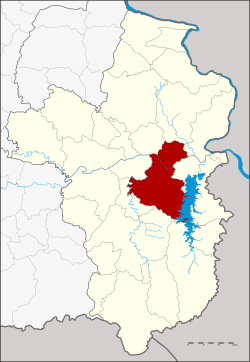 District location in Ubon Ratchathani Province | |
| Coordinates: 15°14′40″N 105°13′44″E | |
| Country | Thailand |
| Province | Ubon Ratchathani |
| Seat | Phibun |
| Tambon | 14 |
| Muban | 180 |
| Area | |
| • Total | 1,280.0 km2 (494.2 sq mi) |
| Population (2016) | |
| • Total | 132,105 |
| • Density | 99.5/km2 (258/sq mi) |
| Time zone | UTC+7 (ICT) |
| Postal code | 34110 |
| Geocode | 3419 |
Geography
Neighboring districts are (from the south clockwise) Buntharik, Det Udom, Na Yia, Sawang Wirawong, Tan Sum, Si Mueang Mai, Khong Chiam and Sirindhorn of Ubon Ratchathani Province.
History
Originally named Phimun Mangsahan (พิมูลมังสาหาร), it was renamed to Phibun Mangsahan on 30 July 1940.[1]
Administration
Central administration
Phibun Mangsahan is divided into 14 sub-districts (tambons), which are further subdivided into 180 administrative villages (mubans).
| No. | Name | Thai | Villages | Pop.[2] |
|---|---|---|---|---|
| 1. | Phibun | พิบูล | - | 10,712 |
| 2. | Kut Chomphu | กุดชมภู | 19 | 14,795 |
| 4. | Don Chik | ดอนจิก | 23 | 14,745 |
| 5. | Sai Mun | ทรายมูล | 10 | 6,020 |
| 6. | Na Pho | นาโพธิ์ | 11 | 8,377 |
| 7. | Non Klang | โนนกลาง | 12 | 7,648 |
| 9. | Pho Sai | โพธิ์ไทร | 19 | 11,931 |
| 10. | Pho Si | โพธิ์ศรี | 14 | 12,643 |
| 11. | Rawe | ระเว | 12 | 8,505 |
| 12. | Rai Tai | ไร่ใต้ | 15 | 8,038 |
| 13. | Nong Bua Hi | หนองบัวฮี | 16 | 10,706 |
| 14. | Ang Sila | อ่างศิลา | 12 | 7,898 |
| 18. | Non Kalong | โนนกาหลง | 9 | 4,840 |
| 19. | Ban Khaem | บ้านแขม | 8 | 5,247 |
Missing numbers belong to tambon which now form Sirindhorn District.
Local administration
There is one town (thesaban mueang) in the district:
- Phibun Mangsahan (Thai: เทศบาลเมืองพิบูลมังสาหาร) consisting of sub-district Phibun.
There are four sub-district municipalities (thesaban tambon) in the district:
- Ang Sila (Thai: เทศบาลตำบลอ่างศิลา) consisting of parts of sub-district Ang Sila.
- Kut Chomphu (Thai: เทศบาลตำบลกุดชมภู) consisting of sub-district Kut Chomphu.
- Pho Sai (Thai: เทศบาลตำบลโพธิ์ไทร) consisting of sub-district Pho Sai.
- Pho Si (Thai: เทศบาลตำบลโพธิ์ศรี) consisting of sub-district Pho Si.
There are 10 sub-district administrative organizations (SAO) in the district:
- Don Chik (Thai: องค์การบริหารส่วนตำบลดอนจิก) consisting of sub-district Don Chik.
- Sai Mun (Thai: องค์การบริหารส่วนตำบลทรายมูล) consisting of sub-district Sai Mun.
- Na Pho (Thai: องค์การบริหารส่วนตำบลนาโพธิ์) consisting of sub-district Na Pho.
- Non Klang (Thai: องค์การบริหารส่วนตำบลโนนกลาง) consisting of sub-district Non Klang.
- Rawe (Thai: องค์การบริหารส่วนตำบลระเว) consisting of sub-district Rawe.
- Rai Tai (Thai: องค์การบริหารส่วนตำบลไร่ใต้) consisting of sub-district Rai Tai.
- Nong Bua Hi (Thai: องค์การบริหารส่วนตำบลหนองบัวฮี) consisting of sub-district Nong Bua Hi.
- Ang Sila (Thai: องค์การบริหารส่วนตำบลอ่างศิลา) consisting of parts of sub-district Ang Sila.
- Non Kalong (Thai: องค์การบริหารส่วนตำบลโนนกาหลง) consisting of sub-district Non Kalong.
- Ban Khaem (Thai: องค์การบริหารส่วนตำบลบ้านแขม) consisting of sub-district Ban Khaem.
References
- พระราชกฤษฎีกาเปลี่ยนนามอำเภอและตำบลบางแห่ง พุทธศักราช ๒๔๘๓ (PDF). Royal Gazette (in Thai). 57 (0 ก): 263–267. July 30, 1940.
- "Population statistics 2016" (in Thai). Department of Provincial Administration. Retrieved 2017-05-04.