Phato District
Phato (Thai: พะโต๊ะ, pronounced [pʰā.tóʔ]) is a district (amphoe) of Chumphon Province, southern Thailand.
Phato พะโต๊ะ | |
|---|---|
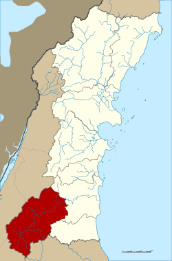 District location in Chumphon Province | |
| Coordinates: 9°47′30″N 98°46′36″E | |
| Country | Thailand |
| Province | Chumphon |
| Seat | Phato |
| Area | |
| • Total | 928.0 km2 (358.3 sq mi) |
| Population (2008) | |
| • Total | 22,633 |
| • Density | 23.9/km2 (62/sq mi) |
| Time zone | UTC+7 (ICT) |
| Postal code | 86180 |
| Geocode | 8606 |
History
Originally Patho was a district of Mueang Lang Suan, which was abolished and included in Chumphon Province in 1932. In 1938 Phato was reduced to a minor district (king amphoe).[1] On 19 June 1991 it was upgraded to a full district.[2]
Geography
Neighboring districts are (from the east clockwise) Lang Suan and Lamae of Chumphon Province, Tha Chana and Chaiya of Surat Thani Province, Kapoe, Mueang Ranong, and La-un of Ranong Province.
Within the Kuan Mae Yai Mon Wildlife Sanctuary in the southwest of the district is the Heo Lom waterfall, one of the attractions of the district. The terrain is mostly mountainous with several small rivers, which make it a popular place for rafting.
Symbols
The slogan of the district is "Green hills, go rafting, see fog cover, beautiful waterfall, famous for fruits."
Administration
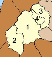
The district is divided into four sub-districts (tambons), which are further subdivided into 43 villages (mubans). The sub-district municipality (thesaban tambon) Phato covers part of the tambon Phato, the sub-district municipality Pak Song the entire sub-district of the same name. There are a further three tambon administrative organizations.
|
 |
References
- ประกาศสำนักนายกรัฐมนตรี เรื่อง ยุบรวมอำเภอ และยุบอำเภอลงเป็นกิ่งอำเภอ (PDF). Royal Gazette (in Thai). 55 (0 ง): 1840. August 29, 1938.
- พระราชกฤษฎีกาตั้งอำเภอทุ่งตะโก อำเภอพะโต๊ะ อำเภอเขาค้อ อำเภอน้ำหนาว อำเภอวังจันทร์ อำเภอนาด้วง อำเภอเต่างอย อำเภอสิงหนคร อำเภอพระสมุทรเจดีย์ และอำเภอลำดวน พ.ศ. ๒๕๓๔ (PDF). Royal Gazette (in Thai). 108 (107 ก Special): 29–33. June 19, 1991.
- "Population statistics 2008". Department of Provincial Administration.
External links