Perry Vale
Perry Vale is a neighbourhood and electoral ward in the London Borough of Lewisham. It is 10.5 km (6.5 mi) southeast of Charing Cross and located near Forest Hill to the east of Forest Hill railway station, where the railway line forms the western boundary. The ward is named after the main road Perry Vale which passes through, this road is part of the B227 road which is called Perry Rise further to the south. The electoral ward has existed since the London Borough of Lewisham revised its wards and ward boundaries in 2002.

| Perry Vale | |
|---|---|
 | |
 Perry Vale Location within Greater London | |
| Population | 15,618 (2011 Census. Ward)[1] |
| OS grid reference | TQ36017254 |
| London borough | |
| Ceremonial county | Greater London |
| Region | |
| Country | England |
| Sovereign state | United Kingdom |
| Post town | LONDON |
| Postcode district | SE23 |
| Dialling code | 020 |
| Police | Metropolitan |
| Fire | London |
| Ambulance | London |
| UK Parliament |
|
| London Assembly | |
From 1978 to 2002 a similarly named ward Perry Hill existed. It was smaller and covered some of the same area, but was slightly more to the east. This ward was named after the A212 road which is called Perry Hill as it passes through running from Catford to Sydenham.
References
- "Lambeth Ward population 2011". Neighbourhood Statistics. Office for National Statistics. Retrieved 13 October 2016.
| Districts | 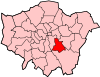 | |
|---|---|---|
| Attractions |
| |
| Parks and open spaces |
| |
| Constituencies | ||
| Rail stations | ||
| Other topics | ||
| ||