Paul Smiths, New York
Paul Smiths is a hamlet and census-designated place (CDP) in the Town of Brighton in Franklin County, New York, United States. It is located on Lower Saint Regis Lake in the Adirondacks, 12 miles (19 km) northwest of Saranac Lake, located at 44°26' North 74°15' West. The population of the CDP was 671 at the 2010 census.[1]
Paul Smiths, New York | |
|---|---|
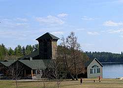 Paul Smiths College student center | |
 Paul Smiths Location within the state of New York | |
| Coordinates: 44°26′10″N 74°15′7″W | |
| Country | United States |
| State | New York |
| County | Franklin |
| Town | Brighton |
| Area | |
| • Total | 0.39 sq mi (1.01 km2) |
| • Land | 0.25 sq mi (0.66 km2) |
| • Water | 0.14 sq mi (0.35 km2) |
| Elevation | 1,600 ft (500 m) |
| Population (2010) | |
| • Total | 671 |
| • Density | 2,629/sq mi (1,015.0/km2) |
| Time zone | UTC-5 (Eastern (EST)) |
| • Summer (DST) | UTC-4 (EDT) |
| ZIP code | 12970 |
| Area code(s) | 518 |
| FIPS code | 36-56770 |
| GNIS feature ID | 970460 |
History
The hamlet was named after the Paul Smith's Hotel (formally known as the Saint Regis House), founded in 1859 by Apollos "Paul" Smith as one of the first wilderness resorts in the Adirondacks. Paul Smith's College was built on the site of the hotel after the hotel burned down in 1930. It was funded by the estate of Smith's son Phelps, who died in 1937.
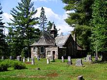
Northbrook Lodge was listed on the National Register of Historic Places in 2014.[2]
Geography
Paul Smiths is located in the southern part of the Town of Brighton, between Lower St. Regis Lake to the south and Osgood Pond to the north. It is in southern Franklin County. The CDP limits correspond to the campus of Paul Smith's College.
New York State Route 30 passes Paul Smiths, leading north 32 miles (51 km) to Malone, the Franklin County seat, and south 26 miles (42 km) to Tupper Lake. New York State Route 86 begins at Paul Smiths and leads 12 miles (19 km) southeast to Saranac Lake village.
According to the U.S. Census Bureau, the Paul Smiths CDP has a total area of 0.39 square miles (1.01 km2), of which 0.25 square miles (0.66 km2) is land and 0.14 square miles (0.35 km2), or 34.63%, is water, consisting of part of Lower St. Regis Lake.
Climate
The Köppen Climate Classification sub-type for this climate is "Dfb" (Warm Summer Continental Climate).[3] Paul Smiths has a record high of 100 set in July 1936 and a record low of -48 set in January 1912, tying the state record low for January.
| Climate data for Paul Smiths | |||||||||||||
|---|---|---|---|---|---|---|---|---|---|---|---|---|---|
| Month | Jan | Feb | Mar | Apr | May | Jun | Jul | Aug | Sep | Oct | Nov | Dec | Year |
| Average high °C (°F) | −2 (28) |
−1 (31) |
3 (37) |
12 (53) |
19 (66) |
24 (75) |
26 (79) |
24 (76) |
20 (68) |
14 (58) |
7 (44) |
−1 (31) |
12 (54) |
| Average low °C (°F) | −14 (6) |
−14 (7) |
−9 (15) |
−2 (29) |
4 (39) |
9 (49) |
11 (52) |
10 (50) |
7 (44) |
1 (34) |
−3 (26) |
−11 (12) |
−1 (30) |
| Average precipitation mm (inches) | 58 (2.3) |
64 (2.5) |
66 (2.6) |
69 (2.7) |
79 (3.1) |
86 (3.4) |
91 (3.6) |
100 (4) |
79 (3.1) |
74 (2.9) |
81 (3.2) |
84 (3.3) |
930 (36.7) |
| Source: Weatherbase [4] | |||||||||||||
See also
- Apollos Smith
- Paul Smith's College Visitor Interpretive Center
References
- "Geographic Identifiers: 2010 Census Summary File 1 (G001), Paul Smiths CDP, New York". American FactFinder. U.S. Census Bureau. Archived from the original on February 13, 2020. Retrieved June 16, 2016.
- "National Register of Historic Places Listings". Weekly List of Actions Taken on Properties: 4/07/14 through 4/11/14. National Park Service. 2014-04-18.
- Climate Summary for Paul Smiths, New York
- "Weatherbase.com". Weatherbase. 2013. Retrieved on Aug 1, 2013.
Further reading
- Jerome, Christine. Adirondack Passage: Cruise of Canoe Sairy Gamp, HarperCollins, 1994.
External links
| Wikimedia Commons has media related to Paul Smiths, New York. |
- New York Times, June 13, 1909, "PAUL SMITH'S.; The Vanderbilt Japanese Camp Being Made Ready for Occupancy."
- Read or listen to the Oral history of Paul Smiths in the late 19th early 20th Centuries
Municipalities and communities of Franklin County, New York, United States | ||
|---|---|---|
| Towns |  Map of New York highlighting Franklin County | |
| Villages | ||
| CDPs | ||
| Hamlets | ||
| Indian reservation | ||
| Footnotes | ‡This populated place also has portions in an adjacent county or counties | |
| Authority control |
|
|---|