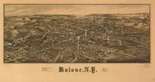
Malone, New York
Malone is a town[3] in New York State. The population was 14,545 at the 2010 census. The town contains a village also named Malone. The town is an interior town located in the north-central part of the county.
Malone, New York | |
|---|---|
Town | |
 | |
 Malone Location within the state of New York | |
| Coordinates: 44°50′56″N 074°17′29″W | |
| Country | United States |
| State | New York |
| Counties | Franklin |
| Government | |
| • Type | Town Council |
| • Town Supervisor | Andrea Stewart (R) |
| • Town Council | Members' List
|
| Area | |
| • Total | 102.80 sq mi (266.26 km2) |
| • Land | 101.52 sq mi (262.94 km2) |
| • Water | 1.28 sq mi (3.32 km2) |
| Elevation | 790 ft (240 m) |
| Population (2010) | |
| • Total | 14,545 |
| • Estimate (2016)[2] | 14,092 |
| • Density | 138.81/sq mi (53.59/km2) |
| Time zone | UTC−5 (Eastern (EST)) |
| • Summer (DST) | UTC−4 (EDT) |
| ZIP Code | 12953 |
| Area code(s) | 518 |
| FIPS code | 36-033-44721 |
| GNIS feature ID | 979185 |
| Website | www |
History
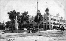
The town was formed from part of the town of Chateaugay in 1805. The town was originally named "Harison", after Richard Harison who had purchased the land and founded the town. The name was changed in 1808 to "Ezraville", after Ezra L'Hommedieu, and in 1812 to "Malone".
During the War of 1812 the village was sacked by British troops making incursions from what would become Canada.
Former Governor Mario Cuomo instituted financial measures to increase economic stability to the county by bringing in many prisons (state and federal).
Notable people
- Tom Browning (born 1960), Major League Baseball pitcher
- Ovila Cayer (1844–1909), recipient of the Medal of Honor for actions during the Battle of Globe Tavern
- Alexander Duane (1858–1926), ophthalmologist
- William H. Flack (1861–1907), US congressman
- Orville Gibson (1856–1911), founder of the Gibson Guitar Corporation
- Michael Hastings (1980–2013), investigative journalist
- William H. Huntington (1848–1916), former Wisconsin State Assemblyman
- Clarence E. Kilburn (1893–1975), Republican member of the United States House of Representatives
- Bob Mould (born 1960), solo musician and former guitarist, singer, and songwriter with alternative rock bands Hüsker Dü and Sugar
- Charles L. Russell (1844–1910), recipient of the Medal of Honor for actions during the Battle of Spotsylvania Court House
- Howard Siler (1945–2014), former USA bobsledder, and coach of the Jamaican bobsled team at the 1988 Winter Olympics
- Frank Tolan (1854–99), recipient of the Medal of Honor for actions at the Battle of the Little Bighorn
- William A. Wheeler (1819–87), the 19th Vice President of the United States, serving under Rutherford B. Hayes. He is buried at Morningside Cemetery in Malone, and his mansion on Elm Street is now the site of the Elks Lodge
- Almanzo Wilder (1857–1949), husband of Little House on the Prairie author Laura Ingalls Wilder
- Philip Woolley (1831–1912), Canadian American businessman
Geography
According to the United States Census Bureau, the town has a total area of 102.8 square miles (266.3 km2), of which 101.5 square miles (262.9 km2) is land and 1.3 square miles (3.3 km2), or 1.25%, is water.[4]
U.S. Route 11 and New York State Route 11B are east-west highways across the town, and New York State Route 30 and New York State Route 37 are north-south highways.
The Salmon River flows northward through the center of town, and the Trout River flows across the northeast corner.

Demographics
| Historical population | |||
|---|---|---|---|
| Census | Pop. | %± | |
| 1820 | 1,150 | — | |
| 1830 | 2,207 | 91.9% | |
| 1840 | 3,229 | 46.3% | |
| 1850 | 4,550 | 40.9% | |
| 1860 | 6,565 | 44.3% | |
| 1870 | 7,186 | 9.5% | |
| 1880 | 7,909 | 10.1% | |
| 1890 | 8,991 | 13.7% | |
| 1900 | 10,009 | 11.3% | |
| 1910 | 10,154 | 1.4% | |
| 1920 | 10,830 | 6.7% | |
| 1930 | 11,798 | 8.9% | |
| 1940 | 11,987 | 1.6% | |
| 1950 | 12,644 | 5.5% | |
| 1960 | 11,997 | −5.1% | |
| 1970 | 11,400 | −5.0% | |
| 1980 | 11,276 | −1.1% | |
| 1990 | 12,982 | 15.1% | |
| 2000 | 14,981 | 15.4% | |
| 2010 | 14,545 | −2.9% | |
| Est. 2016 | 14,092 | [2] | −3.1% |
| U.S. Decennial Census[5] | |||
At the 2000 census there were 14,981 people, 4,114 households, and 2,620 families in the town. The population density was 147.1 people per square mile (56.8/km²). There were 4,644 housing units at an average density of 45.6 per square mile (17.6/km²). The ethnic makeup of the town was 73.61% White, 18.56% Black or African American, 0.49% Native American, 0.63% Asian, 6.25% from other races, and 0.45% from two or more races. Hispanic or Latino of any race were 11.19%.[6] Malone, New York has a far more diverse demographic profile compared to the surrounding region, due to hosting multiple state correctional facilities, which house prisoners from the entirety of New York. Malone also hosts the county correctional facility for Franklin County.[7]
Of the 4,114 households 30.2% had children under the age of 18 living with them, 46.5% were married couples living together, 12.7% had a female householder with no husband present, and 36.3% were non-families. 30.7% of households were one person and 14.3% were one person aged 65 or older. The average household size was 2.36 and the average family size was 2.91.
The age distribution was 16.3% under the age of 18, 10.4% from 18 to 24, 42.1% from 25 to 44, 19.2% from 45 to 64, and 12.1% 65 or older. The median age was 36 years. For every 100 females, there were 179.4 males. For every 100 females age 18 and over, there were 201.5 males.
The median household income was $27,716 and the median family income was $37,500. Males had a median income of $25,996 versus $20,506 for females. The per capita income for the town was $17,352.
According to [8] the Census 2017 ACS 5Year Estimates, the poverty rate in Malone is 24%. The child poverty rate is 31%. (A previous statistic here said the poverty rate was only 8%).
Communities and locations in the Town of Malone
- Bare Hill Correctional Facility – a New York medium security state prison
- Chasm Falls – a hamlet in the southeast part of the town on County Road 25; originally called Titusville[9]
- Fay – a hamlet by the north town line
- Franklin Correctional Facility – a New York medium security state prison
- Lake Titus – a lake in the southwest part of the town
- Malone – a village located in the center of the town and the county seat of Franklin County
- Malone-Dufort Airport (MAL) – an airport west of the village of Malone
- Malone Junction – a hamlet northeast of the village of Malone
- Teboville – a hamlet in the central part of the town, east of Whippleville
- Titus Mountain – a ski area spread over 3 mountains 7 miles (11 km) south of the village of Malone
- Upstate Correctional Facility – a New York maximum security state prison
- Whippleville – a hamlet in the central part of the town, located south of the village of Malone on County Road 25[10]
References
- "2016 U.S. Gazetteer Files". United States Census Bureau. Retrieved Jul 5, 2017.
- "Population and Housing Unit Estimates". Retrieved June 9, 2017.
- .Y. TWN. LAW § 2 : NY Code - Section 2: Definition of town
- "Geographic Identifiers: 2010 Census Summary File 1 (G001), Malone town, Franklin County, New York". American FactFinder. U.S. Census Bureau. Archived from the original on February 13, 2020. Retrieved June 13, 2016.
- "Census of Population and Housing". Census.gov. Retrieved June 4, 2015.
- "U.S. Census website". United States Census Bureau. Retrieved 2008-01-31.
- "Archived copy". Archived from the original on 2016-11-21. Retrieved 2018-04-22.CS1 maint: archived copy as title (link)
- https://factfinder.census.gov/bkmk/table/1.0/en/ACS/17_5YR/S1701/0600000US3603344721%5B%5D
- Oral history of Chasm Falls in the late 19th early 20th Centuries
- Oral history of Whippleville and Teboville in the late 19th early 20th Centuries
External links
| Wikivoyage has a travel guide for Malone, New York. |
- Official website
- Early Malone history
- Malone Historical Map Online
- Read and Listen to the oral history of Malone in the late 19th early 20th Centuries
Municipalities and communities of Franklin County, New York, United States | ||
|---|---|---|
| Towns |  Map of New York highlighting Franklin County | |
| Villages | ||
| CDPs | ||
| Hamlets | ||
| Indian reservation | ||
| Footnotes | ‡This populated place also has portions in an adjacent county or counties | |
| Authority control |
|---|