Pashupatinagar, Ilam
Pashupatinagar is a neighborhood in Suryodaya Municipality of Ilam District of Province No. 1 in Nepal. Previously it was a separate Village Development Committee in Ilam District in the Mechi Zone of Nepal. Pashupatinagar was Incorporated with Suryodaya municipality in 2017 and divided into two wards. The ward no. 2 and 3.
Pashupatinagar पशुपतिनगर Paspati | |
|---|---|
Neighborhood | |
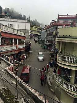 A street in Pashupatinagar | |
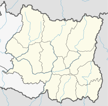 Pashupatinagar Location in Nepal  Pashupatinagar Pashupatinagar (Nepal) | |
| Coordinates: 26°56′35″N 88°6′52″E | |
| Country | |
| Province | Province No. 1 |
| District | Ilam |
| Municipality | Suryodaya |
| part of | ward no. 2 & 3 |
| Elevation | 2,000 m (7,000 ft) |
| Population (1991) | |
| • Total | 6,776 |
| Time zone | UTC+5:45 (Nepal Time) |
| Postal code | 57303 |
| Area code(s) | 027 |
Demographics
At the time of the 2011 Nepal census it had a population of 29,0082 persons living in 1980 individual households.[1]
Transport
Pashupatinagar is near Nepal's eastern border at Darjeeling District, West Bengal State, India. There is a border crossing to Sukhiapokhri town with a customs checkpoint. Indian and Nepalese nationals cross without restriction.
References
- "Nepal Census 2011". Nepal's Village Development Committees. Maiti Nepal.
This article is issued from Wikipedia. The text is licensed under Creative Commons - Attribution - Sharealike. Additional terms may apply for the media files.