Pantar
Pantar (Indonesian: Pulau Pantar) is the second largest island in the Indonesian Alor Archipelago, after Alor. To the east is the island of Alor and other small islands in the archipelago; to the west is the Alor Strait, which separates it from the Solor Archipelago. To the south is the Ombai Strait, and 72 kilometres (45 mi) away, the island of Timor. To the north is the Banda Sea. Pantar is about 50 kilometres (31 mi) north-to-south, and varies from 11 to 29 kilometres (6.8 to 18.0 mi) in east-west width. It has an area of 728 square kilometres (281 sq mi). The main towns on the island are Baranusa and Kabir. Administratively, the island is part of the Alor Regency.
| Native name: Pulau Pantar | |
|---|---|
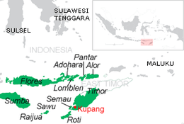 Map of the islands of East Nusa Tenggara, including Pantar | |
| Geography | |
| Coordinates | 8°15′S 124°45′E |
| Archipelago | Alor archipelago, Lesser Sunda Islands |
| Area | 728 km2 (281 sq mi) |
| Administration | |
Indonesia | |
| Province | East Nusa Tenggara |
| Regency | Alor |
| Largest settlement | Baranusa and Kabir |
| Demographics | |
| Population | 39,856 |
Geography
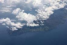
The island consists of two distinct geographic zones. The eastern zone is dominated by a range of verdant hills which drop steeply to the coast of the Alor Strait. The western zone is relatively flat, consisting of a plain which gently slopes to the west from Mount Sirung, an 862-metre-high (2,828-foot) active volcano. The western zone is characteristically drier and much less densely populated than the eastern zone. Owing to its relatively low elevation, the entire island is drier than neighboring Alor. The dry season is long, interspersed with heavy rainfall during the rainy season, which peaks during January and February.
History
The earliest written reference to Pantar is in the fourteenth-century Javanese poem Nagarakretagama, which describes the power and extent of the empire ruled by the fourth king of Majapahit, Hayam Wuruk. Pantar is referred to with the term 'Galiao', which is known in the Alor archipelago.[1] The precise location of the Majapahit dependency within Pantar is a subject of discussion.[2][3][4]
Economy
The economy is dominated by subsistence agriculture and fishing. The most common crops are rice, corn, and cassava. Crops are harvested annually in April and stored for consumption throughout the dry season. Excess production is sometimes traded for fish or to help support school children studying in the district capital of Kalabahi. Recently, commercial production of seaweed has been promoted along the north coast. A limited craft industry focused on ikat weaving is centered in Baranusa. Tourism remains underdeveloped, though a small dive resort was recently established on the northeast coast.
Transportation
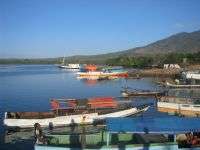
Access to the island is by water only; there is no airstrip on Pantar. Small wooden power boats ply the route between Alor and Pantar daily, serving numerous communities. The state-run ferry serves Baranusa weekly between Kalabahi (Alor) and Larantuka (Flores).
Administration
Pantar is part of Alor Regency, comprising five districts (kecamatan), and has 39,896 residents at the 2010 Census.[5] Within this administration lie some small islets to the west.
| Name | English name | Population Census 2010 |
|---|---|---|
| Pantar | 8,798 | |
| Pantar Barat | West Pantar | 6,729 |
| Pantar Barat Laut | Northwest Pantar | 4,276 |
| Pantar Tengah | Central Pantar | 9,313 |
| Pantar Timur | East Pantar | 10,740 |
Languages
At least eight different languages are spoken on Pantar. These include at least five (dependent on classification) Papuan languages belonging to the Alor–Pantar family (Western Pantar, Sar, Blagar, Nedebang, and Kaera) as well as the Austronesian language Alorese. A small community of Bajau speakers is located north of Kabir. Local varieties of Malay and more standardized Indonesian are used as languages of wider communication.[6]
See also
References
- Barnes, R.H. 1982. "The Majapahit dependency Galiyao". Bijdragen Tot De Taal-, Land- En Volkenkunde. 138 (4): 407-412.
- Rodemeier, Susanne. 1995. "Local tradition on Alor and Pantar; An attempt at localizing Galiyao". Bijdragen Tot De Taal-, Land- En Volkenkunde / Journal of the Humanities and Social Sciences of Southeast Asia. 151 (3): 438-442.
- Holton, Gary. 2010. An etymology for Galiyao. Manuscript. University of Alaska at Fairbanks. https://www.academia.edu/2091684/An_etymology_for_Galiyao
- Kondi, Dominicus Dionitius Pareira, and Alexius BoEr Pareira. 2010. The stranger-kings of Sikka with an integrated edition of two manuscripts on the origin and history of the rajadom of Sikka. Leiden: KITLV Press. http://site.ebrary.com/id/10745941.
- http://sp2010.bps.go.id/files/ebook/5307.pdf
- Klamer, Marian. 2010. A Grammar of Teiwa. Berlin: Mouton.
External links
| Wikimedia Commons has media related to Pantar. |