Ouarzazate
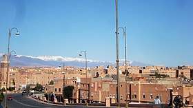
Ouarzazate (Arabic: ورزازات Warzāzāt, Kabyle: ⵡⴰⵔ ⵣⴰⵣⴰⵝ Warzazat), nicknamed the door of the desert, is a city and capital of Ouarzazate Province in Drâa-Tafilalet region of south-central Morocco. Ouarzazate is at an elevation of 1,160 metres (3,810 ft) in the middle of a bare plateau south of the High Atlas Mountains, with a desert to the city's south.
Ouarzazate ⵡⴰⵔ ⵣⴰⵣⴰⵝ ورزازات | |
|---|---|
    | |
| Nickname(s): Door of the Desert | |
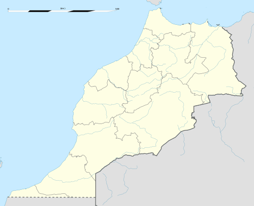 Ouarzazate Location in Morocco | |
| Coordinates: 30°55′N 6°55′W | |
| Country | |
| Region | Drâa-Tafilalet |
| Province | Ouarzazate |
| Area | |
| • Total | 305 km2 (118 sq mi) |
| Elevation | 1,151 m (3,776 ft) |
| Population (2014)[1] | |
| • Total | 71,067 |
| • Density | 233/km2 (600/sq mi) |
Berber-speakers make up the majority of the town's inhabitants, who were responsible for the creation of many of the prominent kasbahs (locally referred to as: iɣeṛman). Ouarzazate is a primary tourist destination in Morocco for holidays, as well as a starting point for excursions into and across the Draa Valley and the desert. Aït Benhaddou (a fortified village) west of the city is a UNESCO World Heritage Site.
The Ouarzazate area is a noted film-making location, with Morocco's biggest studios inviting many international companies to work here. Films such as Lawrence of Arabia (1962), The Man Who Would Be King (1975), The Living Daylights (1987), The Last Temptation of Christ (1988), The Mummy (1999), Gladiator (2000), Kingdom of Heaven (2005), Kundun (1997), Legionnaire (1998), Hanna (2011), The Hills Have Eyes (2006), and Salmon Fishing in the Yemen (2011) were shot here, as was part of the TV series Game of Thrones.
The nearby Ouarzazate solar power station, co-funded by the Arab League,[2] was connected to the Moroccan power grid in February 2016.[3][4]
Etymology
Its name comes from a Berber phrase meaning "without noise" or "without confusion".
History
For a long time, Ouarzazate was a small crossing point for African traders on their way to northern Morocco and Europe. In the 16th century, Sheikh Abu al-'Abaas Ahmed bin Abdellah al-Wizkiti al-Warzazi, amir of the qasba of Warzazat and father of Lalla Masuda, helped establish Saadi control over the Sous-Dra'a region.[5][6]
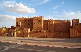
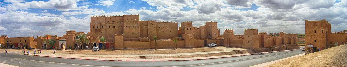
During the French period, Ouarzazate expanded considerably as a garrison town, administrative centre and customs post. It is home to the kasbah of Taourirt, which was the casbah of the former caïd and later owned by T'hami El Glaoui. The Krupp field gun which secured Glaoui power is displayed outside the kasbah today.
The area is also known for its Ouazguita carpets with geometric designs of red-orange on black background.
Climate
Ouarzazete has a hot desert climate (Köppen climate classification BWh). The city is hot and dry in summer, but can be very cold in winter, with icy winds coming from the High Atlas Mountains.
| Climate data for Ouarzazate (1961–1990, extremes 1941–1963 and 1965–present)[lower-alpha 1] | |||||||||||||
|---|---|---|---|---|---|---|---|---|---|---|---|---|---|
| Month | Jan | Feb | Mar | Apr | May | Jun | Jul | Aug | Sep | Oct | Nov | Dec | Year |
| Record high °C (°F) | 26.6 (79.9) |
29.8 (85.6) |
32.0 (89.6) |
34.8 (94.6) |
39.2 (102.6) |
43.6 (110.5) |
43.4 (110.1) |
44.0 (111.2) |
43.2 (109.8) |
34.9 (94.8) |
30.5 (86.9) |
27.0 (80.6) |
44.0 (111.2) |
| Average high °C (°F) | 16.6 (61.9) |
19.3 (66.7) |
22.2 (72.0) |
25.1 (77.2) |
29.6 (85.3) |
34.1 (93.4) |
37.8 (100.0) |
37.0 (98.6) |
32.2 (90.0) |
26.5 (79.7) |
20.4 (68.7) |
16.7 (62.1) |
26.5 (79.7) |
| Daily mean °C (°F) | 9.3 (48.7) |
11.9 (53.4) |
14.8 (58.6) |
17.6 (63.7) |
21.7 (71.1) |
25.9 (78.6) |
29.5 (85.1) |
28.8 (83.8) |
24.6 (76.3) |
19.4 (66.9) |
13.7 (56.7) |
9.5 (49.1) |
18.9 (66.0) |
| Average low °C (°F) | 1.9 (35.4) |
4.5 (40.1) |
7.4 (45.3) |
10.0 (50.0) |
13.8 (56.8) |
17.7 (63.9) |
21.3 (70.3) |
20.7 (69.3) |
17.1 (62.8) |
12.3 (54.1) |
6.9 (44.4) |
2.4 (36.3) |
11.3 (52.3) |
| Record low °C (°F) | −7.0 (19.4) |
−5.4 (22.3) |
−2.0 (28.4) |
−1.0 (30.2) |
3.6 (38.5) |
7.6 (45.7) |
13.0 (55.4) |
12.6 (54.7) |
9.0 (48.2) |
4.0 (39.2) |
−2.6 (27.3) |
−4.9 (23.2) |
−7.0 (19.4) |
| Average precipitation mm (inches) | 13.0 (0.51) |
13.1 (0.52) |
7.4 (0.29) |
7.4 (0.29) |
7.0 (0.28) |
2.1 (0.08) |
1.4 (0.06) |
5.1 (0.20) |
13.3 (0.52) |
13.4 (0.53) |
19.3 (0.76) |
9.7 (0.38) |
112.2 (4.42) |
| Average precipitation days | 2.9 | 2.8 | 2.2 | 2.0 | 2.3 | 1.3 | 1.6 | 3.3 | 4.9 | 3.4 | 3.8 | 2.4 | 32.9 |
| Average relative humidity (%) | 54 | 46 | 42 | 38 | 33 | 27 | 22 | 27 | 34 | 42 | 61 | 64 | 41 |
| Mean monthly sunshine hours | 251.8 | 244.9 | 297.2 | 315.2 | 332.7 | 335.0 | 317.7 | 293.2 | 266.4 | 271.3 | 242.9 | 248.1 | 3,416.4 |
| Source 1: NOAA[7] | |||||||||||||
| Source 2: Deutscher Wetterdienst (record highs for February, May, July, August, and November, record lows, and humidity)[8] Meteo Climat (all other record highs and record lows for June, July, September and October only)[9] | |||||||||||||
Film studios
Atlas Studios is one of the largest movie studios in the world , in terms of land area. Several historical movies were shot here, including The Living Daylights, Asterix & Obelix: Mission Cleopatra, Lawrence of Arabia, The Man Who Would Be King, Kingdom of Heaven, Gladiator, and Babel. It was also the location of an episode of the television series The Amazing Race 10 and Game of Thrones (Season 3). Prison Break Season 5 is also located here.
Another large studio in Oarzazate is CLA Studios.[10]
Sights nearby
The kasbah-town of Aït Benhaddou is nearby. Many excursions through the valley of the Draa River into the Sahara start from the city. These include trips to Zagora, an oasis town surrounded by palm tree plantations and a departure point for camel trains to Timbuktu, a journey that would take about 52 days. These days the border to Algeria is closed, stopping the Timbuktu route.
The city was part of the route of the 2006 and 2007 Dakar Rally.
Many sights can be visited within the city, but also, a wide list of interesting attractions can be found around Ouarzazate.
Sights around Ouarzazate
- Tifoultoute Kasbah
- Fint Oasis
- Jbel Adad Petroglyphs
- Iguernan Nature Reserve
- Ksar Ait Benhaddou
- Ounila Valley
- Skoura Oasis
- Stork's Kasbah
- CLA Studios
- Atlas Film Studios
- The Abandoned "Hills Have Eyes" movie set
- Tizgui Waterfall
- Al Mansour Dahbi Dam
- Gazelle Animal Natural Reserve of Bouljir
Mapping
Detailed maps are hard to obtain in Morocco. The French IGN mapping at a 1:100,000 scale has been reproduced by the Moroccan Division de la carte. These maps are often out of date and obtained with special permission in Rabat. Soviet mapping on a 1:200,000 scale is available on the Internet, but these are generally outdated and show the names of places in Cyrillic letters.
A new series of maps are available, including the Ouarzazate Region (Map) (1st ed.). 1:160,000 Map and Guide. Atlas Mountains Morocco. Cartography by EWP. EWP and WCP. 2008. ISBN 978-0-906227-99-2.
Gallery
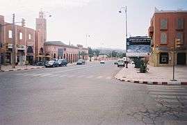 A street in Ouarzazate
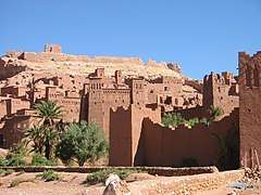 Kasbah Ait Benhaddou
 Kasbah Aksar
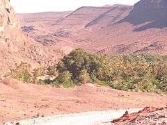 Oasis du Fint
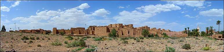 The back side of Kasbah Taourirt
 Ouarzazate old town
See also
- Tizi n'Tichka – The mountain pass that connects Ouarzazate and Marrakesh
- List of movies shot in Morocco
- Ouarzazate Airport
- Ouarzazate solar power station
Notes
- The record highs and lows are based on the Deutscher Wetterdienst link for the period 1941–1963 while records beyond 1965 come from the Meteo Climat link. As a result, the most extreme values from either source are used.
References
- "POPULATION LÉGALE DES RÉGIONS, PROVINCES, PRÉFECTURES, MUNICIPALITÉS, ARRONDISSEMENTS ET COMMUNES DU ROYAUME D'APRÈS LES RÉSULTATS DU RGPH 2014" (in Arabic and French). High Commission for Planning, Morocco. 8 April 2015. Retrieved 29 September 2017.
- Harrabin, Roger (23 November 2015). "Moroccan solar plant to bring energy to a million people". Retrieved 3 October 2016 – via www.bbc.co.uk.
- Vorrath, Sophie (2016-02-05). "First 160MW of huge Noor solar thermal plant connected to Moroccan grid". RenewEconomy. Retrieved 2019-06-04.
- Louis Boisgibault, Fahad Al Kabbani (2020): Energy Transition in Metropolises, Rural Areas and Deserts. Wiley - ISTE. (Energy series) ISBN 9781786304995.
- "سيرة السيدة مسعودة الوزكيتية". وزارة الأوقاف والشؤون الإسلامية. June 24, 2019.
- مغرس مسعودة الوزكيتية .. الأميرة الحسنة Archived 2017-12-23 at the Wayback Machine
- "Ouarzazate Climate Normals 1961–1990". National Oceanic and Atmospheric Administration. Retrieved March 16, 2015.
- "Klimatafel von Ouarzazate / Marokko" (PDF). Baseline climate means (1961–1990) from stations all over the world (in German). Deutscher Wetterdienst. Retrieved October 14, 2016.
- "Station Ouarzazate" (in French). Météo Climat. Retrieved October 14, 2016.
- Rutherford, Tristan (September–October 2017). "Morocco's Cinema City". Aramco World. pp. 24–31.
External links
| Wikimedia Commons has media related to Ouarzazate. |
- Definitely Ouarzazate (facilities for filmmakers)
- Ouarzazate Film Commission
- Cinema Museum of Ouarzazate
- Movies shot in Ouarzazate at IMDb

Capital: Errachidia | ||
| Provinces | 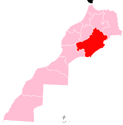 | |
| Cities | ||
| Authority control |
|
|---|