Timbuktu
Timbuktu (/ˌtɪmbʌkˈtuː/) (French: Tombouctou; Koyra Chiini: Tumbutu) is a city in Mali, situated 20 km (12 mi) north of the Niger River. The town is the capital of the Timbuktu Region, one of the eight administrative regions of Mali. It had a population of 54,453 in the 2009 census.
Timbuktu Tinbuktu / Tombouctou Timbuctoo | |
|---|---|
City | |
| transcription(s) | |
| • Koyra Chiini: | Tumbutu |
 Sankore University in Timbuktu | |
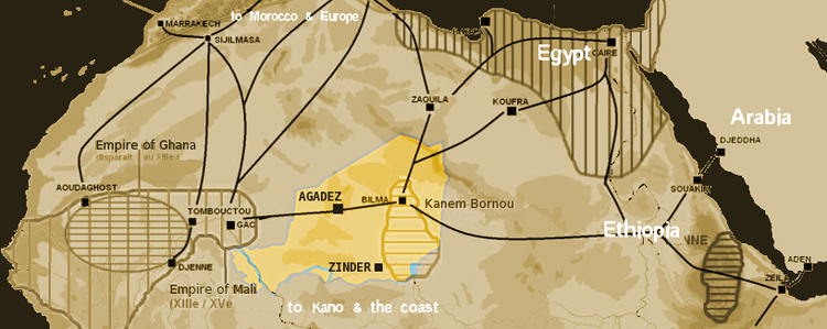 Map showing main trans-Saharan caravan routes circa 1400. Also shown are the Ghana Empire (until the 13th century) and 13th – 15th century Mali Empire, with the western route running from Djenné via Timbuktu to Sijilmassa. Present day Niger in yellow. | |
 Timbuktu Location of Timbuktu within Mali | |
| Coordinates: 16°46′33″N 3°00′34″W | |
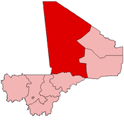
| Country | Mali |
| Region | Tombouctou Region |
| Cercle | Timbuktu Cercle |
| Settled | 5th century BC |
| Government | |
| • Mayor | Hallé Ousmane |
| Elevation | 261 m (856 ft) |
| Population (2009)[1] | |
| • Total | 54,453 |
| Climate | BWh |
| Criteria | Cultural: ii, iv, v |
| Reference | 119 |
| Inscription | 1988 (12th session) |
| Endangered | 1990–2005; 2012–present |
Timbuktu started out as a seasonal settlement and became a permanent settlement early in the 12th century. After a shift in trading routes, Timbuktu flourished from the trade in salt, gold, ivory, and slaves. It became part of the Mali Empire early in the 14th century. In the first half of the 15th century, the Tuareg tribes took control of the city for a short period until the expanding Songhai Empire absorbed the city in 1468. A Moroccan army defeated the Songhai in 1591 and made Timbuktu, rather than Gao, their capital. The invaders established a new ruling class, the Arma, who after 1612 became virtually independent of Morocco. However, the golden age of the city, during which it was a major learning and cultural centre of the Mali Empire, was over, and it entered a long period of decline. Different tribes governed until the French took over in 1893, a situation that lasted until it became part of the current Republic of Mali in 1960. Presently, Timbuktu is impoverished and suffers from desertification.
In its Golden Age, the town's numerous Islamic scholars and extensive trading network made possible an important book trade: together with the campuses of the Sankore Madrasah, an Islamic university, this established Timbuktu as a scholarly centre in Africa. Several notable historic writers, such as Shabeni and Leo Africanus, wrote about the city. These stories fuelled speculation in Europe, where the city's reputation shifted from being extremely rich to being mysterious.
Toponymy
Over the centuries, the spelling of Timbuktu has varied a great deal: from Tenbuch on the Catalan Atlas (1375), to traveller Antonio Malfante's Thambet, used in a letter he wrote in 1447 and also adopted by Alvise Cadamosto in his Voyages of Cadamosto, to Heinrich Barth's Timbúktu and Timbu'ktu. French spelling often appears in international reference as "Tombouctou". As well as its spelling, Timbuktu's toponymy is still open to discussion.[2] At least four possible origins of the name of Timbuktu have been described:
- Songhay origin: both Leo Africanus and Heinrich Barth believed the name was derived from two Songhay words:[2] Leo Africanus writes the Kingdom of Tombuto was named after a town of the same name, founded in 1213 or 1214 by Mansa Suleyman.[3] The word itself consisted of two parts: tin (wall) and butu (Wall of Butu). Africanus did not explain the meaning of this Butu.[2] Heinrich Barth wrote: "The town was probably so called, because it was built originally in a hollow or cavity in the sand-hills. Tùmbutu means hole or womb in the Songhay language: if it were a Temáshight (Tamashek) word, it would be written Timbuktu. The name is generally interpreted by Europeans as well of Buktu (also same word in Persian is bâkhtàr باختر = where the sun sets, West), but tin has nothing to do with well."[4]
- Berber origin: Malian historian Sekene Cissoko proposes a different etymology: the Tuareg founders of the city gave it a Berber name, a word composed of two parts: tim, the feminine form of In (place of) and bouctou, a small dune. Hence, Timbuktu would mean "place covered by small dunes".[5]
- Abd al-Sadi offers a third explanation in his 17th-century Tarikh al-Sudan: "The Tuareg made it a depot for their belongings and provisions, and it grew into a crossroads for travelers coming and going. Looking after their belongings was a slave woman of theirs called Timbuktu, which in their language means [the one having a] 'lump'. The blessed spot where she encamped was named after her."[6]
- The French Orientalist René Basset forwarded another theory: the name derives from the Zenaga root b-k-t, meaning "to be distant" or "hidden", and the feminine possessive particle tin. The meaning "hidden" could point to the city's location in a slight hollow.[7]
The validity of these theories depends on the identity of the original founders of the city: as recently as 2000, archaeological research has not found remains dating from the 11th/12th century within the limits of the modern city given the difficulty of excavating through metres of sand that have buried the remains over the past centuries.[8][9] Without consensus, the etymology of Timbuktu remains unclear.
Prehistory
Like other important Medieval West African towns such as Djenné (Jenné-Jeno), Gao, and Dia, Iron Age settlements have been discovered near Timbuktu that predate the traditional foundation date of the town. Although the accumulation of thick layers of sand has thwarted archaeological excavations in the town itself,[10][9] some of the surrounding landscape is deflating and exposing pottery shards on the surface. A survey of the area by Susan and Roderick McIntosh in 1984 identified several Iron Age sites along the el-Ahmar, an ancient wadi system that passes a few kilometers to the east of the modern town.[11]
An Iron Age tell complex located 9 kilometres (6 miles) southeast of the Timbuktu near the Wadi el-Ahmar was excavated between 2008 and 2010 by archaeologists from Yale University and the Mission Culturelle de Tombouctou. The results suggest that the site was first occupied during the 5th century BC, thrived throughout the second half of the 1st millennium AD and eventually collapsed sometime during the late 10th or early 11th-century AD.[12][13]
History
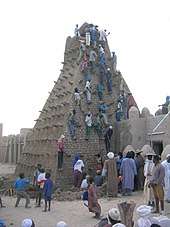
.jpg)
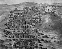
Timbuktu was a regional trade center in medieval times, where caravans met to exchange salt from the Sahara Desert for gold, ivory, and slaves from the Sahel, which could be reached via the nearby Niger River. The population (2018 population 32,460) swelled from 10,000 in the 13th century to about 50,000 in the 16th century after the establishment of a major Islamic university (University of Timbuktu), which attracted scholars from throughout the Muslim world. In the 1600s, a combination of a purge by a monarch who accused the scholars of "disloyalty" and a decline in trade caused by increased competition from newly available trans-Atlantic sailing routes caused the city to decline. The first European to reach Timbuktu, Alexander Gordon Laing, did not arrive until 1826, and it was not until the 1890s that Timbuktu was formally incorporated into the French colony of Mali. Today, the city is still inhabited; however, the city is not as geopolitically relevant as it once was.
Geography
Timbuktu is located on the southern edge of the Sahara 15 km (9 mi) north of the main channel of the River Niger. The town is surrounded by sand dunes and the streets are covered in sand. The port of Kabara is 8 km (5 mi) to the south of the town and is connected to an arm of the river by a 3 km (2 mi) canal. The canal had become heavily silted but in 2007 it was dredged as part of a Libyan financed project.[14]
The annual flood of the Niger River is a result of the heavy rainfall in the headwaters of the Niger and Bani rivers in Guinea and northern Ivory Coast. The rainfall in these areas peaks in August but the floodwater takes time to pass down the river system and through the Inner Niger Delta. At Koulikoro, 60 km (37 mi) downstream from Bamako, the flood peaks in September,[15] while in Timbuktu the flood lasts longer and usually reaches a maximum at the end of December.[16]
In the past, the area flooded by the river was more extensive and in years with high rainfall, floodwater would reach the western outskirts of Timbuktu itself.[17] A small navigable creek to the west of the town is shown on the maps published by Heinrich Barth in 1857[18] and Félix Dubois in 1896.[19] Between 1917 and 1921, during the colonial period, the French used slave labour to dig a narrow canal linking Timbuktu with Kabara.[20] Over the following decades this became silted and filled with sand, but in 2007 as part of the dredging project, the canal was re-excavated so that now when the River Niger floods, Timbuktu is again connected to Kabara.[14][21] The Malian government has promised to address problems with the design of the canal as it currently lacks footbridges and the steep, unstable banks make access to the water difficult.[22]
Kabara can only function as a port in December to January when the river is in full flood. When the water levels are lower, boats dock at Korioumé which is linked to Timbuktu by 18 km (11 mi) of paved road.
Climate
Timbuktu features a hot desert climate (BWh) according to the Köppen Climate Classification. The weather is extremely hot and dry throughout much of the year, with half of the city’s rainfall occurring between June and September, due to the influence of the Intertropical Convergence Zone (ITCZ). The degree of diurnal temperature variation is higher in the dry season than the wet season. Average daily maximum temperatures in the hottest months of the year – April, May and June – exceed 40 °C (104 °F). Lowest temperatures occur during the mildest months of the year – December, January and February. However, average maximum temperatures do not drop below 30 °C (86 °F). These winter months are characterized by a dry, dusty trade wind blowing from the Saharan Tibesti Region southward to the Gulf of Guinea: picking up dust particles on their way, these winds limit visibility in what has been dubbed the 'Harmattan Haze'.[23] Additionally, when the dust settles in the city, sand builds up and desertification looms.[24]
| Climate data for Timbuktu (1950–2000, extremes 1897–present) | |||||||||||||
|---|---|---|---|---|---|---|---|---|---|---|---|---|---|
| Month | Jan | Feb | Mar | Apr | May | Jun | Jul | Aug | Sep | Oct | Nov | Dec | Year |
| Record high °C (°F) | 41.6 (106.9) |
43.5 (110.3) |
46.1 (115.0) |
48.9 (120.0) |
49.0 (120.2) |
49.0 (120.2) |
46.0 (114.8) |
46.5 (115.7) |
45.0 (113.0) |
48.0 (118.4) |
42.5 (108.5) |
40.0 (104.0) |
49.0 (120.2) |
| Average high °C (°F) | 30.0 (86.0) |
33.2 (91.8) |
36.6 (97.9) |
40.0 (104.0) |
42.2 (108.0) |
41.6 (106.9) |
38.5 (101.3) |
36.5 (97.7) |
38.3 (100.9) |
39.1 (102.4) |
35.2 (95.4) |
30.4 (86.7) |
36.8 (98.2) |
| Average low °C (°F) | 13.0 (55.4) |
15.2 (59.4) |
18.5 (65.3) |
22.5 (72.5) |
26.0 (78.8) |
27.3 (81.1) |
25.8 (78.4) |
24.8 (76.6) |
24.8 (76.6) |
22.7 (72.9) |
17.7 (63.9) |
13.5 (56.3) |
21.0 (69.8) |
| Record low °C (°F) | 1.7 (35.1) |
7.5 (45.5) |
7.0 (44.6) |
8.0 (46.4) |
18.5 (65.3) |
17.4 (63.3) |
18.0 (64.4) |
20.0 (68.0) |
18.9 (66.0) |
13.0 (55.4) |
11.0 (51.8) |
3.5 (38.3) |
1.7 (35.1) |
| Average rainfall mm (inches) | 0.6 (0.02) |
0.1 (0.00) |
0.1 (0.00) |
1.0 (0.04) |
4.0 (0.16) |
16.4 (0.65) |
53.5 (2.11) |
73.6 (2.90) |
29.4 (1.16) |
3.8 (0.15) |
0.1 (0.00) |
0.2 (0.01) |
182.8 (7.20) |
| Average rainy days (≥ 0.1 mm) | 0.1 | 0.1 | 0.1 | 0.6 | 0.9 | 3.2 | 6.6 | 8.1 | 4.7 | 0.8 | 0.0 | 0.1 | 25.3 |
| Mean monthly sunshine hours | 263.9 | 249.6 | 269.9 | 254.6 | 275.3 | 234.7 | 248.6 | 255.3 | 248.9 | 273.0 | 274.0 | 258.7 | 3,106.5 |
| Source 1: World Meteorological Organization,[25] NOAA (sun 1961–1990)[26] | |||||||||||||
| Source 2: Meteo Climat (record highs and lows)[27] | |||||||||||||
Economy
Salt trade
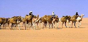
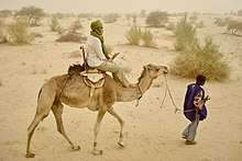
The wealth and very existence of Timbuktu depended on its position as the southern terminus of an important trans-Saharan trade route; nowadays, the only goods that are routinely transported across the desert are slabs of rock salt brought from the Taoudenni mining centre in the central Sahara 664 km (413 mi) north of Timbuktu. Until the second half of the 20th century most of the slabs were transported by large salt caravans or azalai, one leaving Timbuktu in early November and the other in late March.[28]
The caravans of several thousand camels took three weeks each way, transporting food to the miners and returning with each camel loaded with four or five 30 kg (66 lb) slabs of salt. The salt transport was largely controlled by the desert nomads of the Arabic-speaking Berabich (or Barabish) tribe.[29] Although there are no roads, the slabs of salt are now usually transported from Taoudenni by truck.[30] From Timbuktu the salt is transported by boat to other towns in Mali.
Between the 12th and 14th centuries, Timbuktu's population grew immensely due to an influx of Tuaregs, Fulanis, and Songhais seeking trade, security, or to study. By 1300, the population increased to 10,000 and continued increasing until it reached about 50,000 in the 1500s.[31]
Agriculture
There is insufficient rainfall in the Timbuktu region for purely rain-fed agriculture and crops are therefore irrigated using water from the River Niger. The main agricultural crop is rice. African floating rice (Oryza glaberrima) has traditionally been grown in regions near the river that are inundated during the annual flood. Seed is sown at the beginning of the rainy season (June–July) so that when the flood water arrives plants are already 30 to 40 cm (12 to 16 in) in height.[32]
The plants grow up to three metres (9.8 feet) in height as the water level rises. The rice is harvested by canoe in December. The procedure is very precarious and the yields are low but the method has the advantage that little capital investment is required. A successful crop depends critically on the amount and timing of the rain in the wet season and the height of the flood. To a limited extent the arrival of the flood water can be controlled by the construction of small mud dikes that become submerged as the water rises.
Although floating rice is still cultivated in the Timbuktu Cercle, most of the rice is now grown in three relatively large irrigated areas that lie to the south of the town: Daye (392 ha), Koriomé (550 ha) and Hamadja (623 ha).[33] Water is pumped from the river using ten large Archimedes' screws which were first installed in the 1990s. The irrigated areas are run as cooperatives with approximately 2,100 families cultivating small plots.[34] Nearly all the rice produced is consumed by the families themselves. The yields are still relatively low and the farmers are being encouraged to change their agricultural practices.[35]
Tourism
Most tourists visit Timbuktu between November and February when the air temperature is lower. In the 1980s, accommodation for tourists was provided by Hendrina Khan Hotel[36] and two other small hotels: Hotel Bouctou and Hotel Azalaï.[37] Over the following decades the tourist numbers increased so that by 2006 there were seven small hotels and guest houses.[33] The town benefited by the revenue from the CFA 5000 tourist tax,[33] by the sale of handicrafts and by the employment for the guides.
Attacks
Starting in 2008, al-Qaeda in the Islamic Maghreb began kidnapping groups of tourists in the Sahel region.[38] In January 2009, four tourists were kidnapped near the Mali–Niger border after attending a cultural festival at Anderamboukané.[39] One of these tourists was subsequently murdered.[40] As a result of this and various other incidents a number of states including France,[41] Britain[42] and the US,[43] began advising their citizens to avoid travelling far from Bamako. The number of tourists visiting Timbuktu dropped precipitously from around 6000 in 2009 to only 492 in the first four months of 2011.[37]
Because of the security concerns, the Malian government moved the 2010 Festival in the Desert from Essakane to the outskirts of Timbuktu.[44][45] In November 2011, gunmen attacked tourists staying at a hotel in Timbuktu, killing one of them and kidnapping three others.[46][47] This was the first terrorist incident in Timbuktu itself.
On 1 April 2012, one day after the capture of Gao, Timbuktu was captured from the Malian military by the Tuareg rebels of the MNLA and Ansar Dine.[48] Five days later, the MNLA declared the region independent of Mali as the nation of Azawad.[49] The declared political entity was not recognized by any regional nations or the international community and it collapsed three months later on 12 July.[50]
On 28 January 2013, French and Malian government troops began retaking Timbuktu from the Islamist rebels.[51] The force of 1,000 French troops with 200 Malian soldiers retook Timbuktu without a fight. The Islamist groups had already fled north a few days earlier, having set fire to the Ahmed Baba Institute, which housed many important manuscripts. The building housing the Ahmed Baba Institute was funded by South Africa, and held 30,000 manuscripts. BBC World Service radio news reported on 29 January 2013 that approximately 28,000 of the manuscripts in the Institute had been removed to safety from the premises before the attack by the Islamist groups, and that the whereabouts of about 2,000 manuscripts remained unknown.[52] It was intended to be a resource for Islamic research.[53]
On 30 March 2013, jihadist rebels infiltrated into Timbuktu nine days before a suicide bombing on a Malian army checkpoint at the international airport killing a soldier. Fighting lasted until 1 April, when French warplanes helped Malian ground forces chase the remaining rebels out of the city center.
Early accounts in the West
Tales of Timbuktu's fabulous wealth helped prompt European exploration of the west coast of Africa. Among the most famous descriptions of Timbuktu are those of Leo Africanus and Shabeni.
Leo Africanus
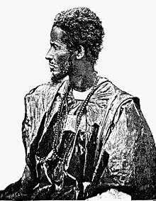
Perhaps most famous among the accounts written about Timbuktu is that by Leo Africanus. Born El Hasan ben Muhammed el- Wazzan-ez-Zayyati in Granada in 1485, his family was among the thousands of Muslims expelled by King Ferdinand and Queen Isabella after their reconquest of Spain in 1492. They settled in Morocco, where he studied in Fes and accompanied his uncle on diplomatic missions throughout North Africa. During these travels, he visited Timbuktu. As a young man he was captured by pirates and presented as an exceptionally learned slave to Pope Leo X, who freed him, baptized him under the name "Johannis Leo de Medici", and commissioned him to write, in Italian, a detailed survey of Africa. His accounts provided most of what Europeans knew about the continent for the next several centuries.[54] Describing Timbuktu when the Songhai Empire was at its height, the English edition of his book includes the description:
The rich king of Tombuto hath many plates and sceptres of gold, some whereof weigh 1300 pounds. ... He hath always 3000 horsemen ... (and) a great store of doctors, judges, priests, and other learned men, that are bountifully maintained at the king's cost and charges.
According to Leo Africanus, there were abundant supplies of locally produced corn, cattle, milk and butter, though there were neither gardens nor orchards surrounding the city.[55] In another passage dedicated to describing the wealth of both the environment and the king, Africanus touches upon the rarity of one of Timbuktu's trade commodities: salt.
The inhabitants are very rich, especially the strangers who have settled in the country [..] But salt is in very short supply because it is carried here from Tegaza, some 500 miles (805 km) from Timbuktu. I happened to be in this city at a time when a load of salt sold for eighty ducats. The king has a rich treasure of coins and gold ingots.
These descriptions and passages alike caught the attention of European explorers. Africanus also described the more mundane aspects of the city, such as the "cottages built of chalk, and covered with thatch" – although these went largely unheeded.[9]
Shabeni
– Shabeni in James Grey Jackson's An Account of Timbuctoo and Hausa, 1820[56]
Roughly 250 years after Leo Africanus' visit to Timbuktu, the city had seen many rulers. The end of the 18th century saw the grip of the Moroccan rulers on the city wane, resulting in a period of unstable government by quickly changing tribes. During the rule of one of those tribes, the Hausa, a 14-year-old child named Shabeni (or Shabeeny) from Tetuan on the north coast of Morocco accompanied his father on a visit to Timbuktu.[57]
Shabeni stayed in Timbuktu for three years before moving to a major city called Housa[58] several days' journey to the southeast. Two years later, he returned to Timbuktu to live there for another seven years – one of a population that was, even centuries after its peak and excluding slaves, double the size of the 21st-century town.
By the time Shabeni was 27, he was an established merchant in his hometown of Tetuan. He made a two-year pilgrimage to Mecca and thus became a hajji, Asseed El Hage Abd Salam Shabeeny. Returning from a trading voyage to Hamburg, he was captured by a ship manned by Englishmen but sailing under a Russian flag, whose captain claimed that his Imperial mistress (Catherine the Great) was "at war with all Muselmen" (see Russo-Turkish War (1787–1792)). He and the ship he had been sailing in were brought to Ostend in Belgium in December 1789 but the British consul managed to get him and the ship released. He set off again in the same ship, but the captain, who claimed to be afraid of his ship being captured again, set him ashore in Dover. In England his story was recorded. Shabeeni gave an indication of the size of the city in the second half of the 18th century. In an earlier passage, he described an environment that was characterized by forest, as opposed to the modern arid surroundings.
Arts and culture
Cultural events
The most well-known cultural event is the Festival au Désert.[59] When the Tuareg rebellion ended in 1996 under the Konaré administration, 3,000 weapons were burned in a ceremony dubbed the Flame of Peace on 29 March 2007 – to commemorate the ceremony, a monument was built.[60] The Festival au Désert, to celebrate the peace treaty, was held every January in the desert, 75 km from the city until 2010.[59]
The week-long festival of Mawloud is held every January, and celebrates the birthday of the Prophet Muhammed—the city's "most cherished manuscripts" are read publicly, and are a central part of this celebration.[61] It was originally a Shi'ite festival from Persia and arriving in Timbuktu around 1600. The "most joyful occasion on Timbuktu's calender," it combines "rituals of Sufi Islam with celebrating Timbuktu's rich literary traditions."[62] It is a "period of feasting, singing, and dancing...It culminated with an evening gathering of thousands of people in the large sandy square in front of the Sankoré Mosque and a public reading of some of the city's most treasured manuscripts."[62]
World Heritage Site
During its twelfth session, in December 1988, the World Heritage Committee (WHC) selected parts of Timbuktu's historic centre for inscription on its World Heritage list.[63] The selection was based on three criteria:[64]
- Criterion II: Timbuktu's holy places were vital to early Islamization in Africa.
- Criterion IV: Timbuktu's mosques show a cultural and scholarly Golden Age during the Songhai Empire.
- Criterion V: The construction of the mosques, still mostly original, shows the use of traditional building techniques.
An earlier nomination in 1979 failed the following year as it lacked proper demarcation:[64] the Malian government included the town of Timbuktu as a whole in the wish for inclusion.[65] Close to a decade later, three mosques and 16 mausoleums or cemeteries were selected from the Old Town for World Heritage status: with this conclusion came the call for protection of the buildings' conditions, an exclusion of new construction works near the sites and measures against the encroaching sand.
Shortly afterwards, the monuments were placed on the List of World Heritage in Danger by the Malian government, as by the selection committee at the time of nomination.[63] The first period on the Danger List lasted from 1990 until 2005, when a range of measures including restoration work and the compilation of an inventory warranted "its removal from the Danger List".[66] In 2008 the WHC placed the protected area under increased scrutiny dubbed "reinforced monitoring", a measure made possible in 2007, as the impact of planned construction work was unclear. Special attention was given to the build of a cultural centre.[67]
During a session in June 2009, UNESCO decided to cease its increased monitoring program as it felt sufficient progress had been made to address the initial concerns.[68] Following the takeover of Timbuktu by MNLA and the Islamist group Ansar Dine, it was returned to the List of World Heritage in Danger in 2012.[69]
Attacks by Muslim fundamentalists
In May 2012, Ansar Dine destroyed a shrine in the city[70] and in June 2012, in the aftermath of the Battle of Gao and Timbuktu, other shrines, including the mausoleum of Sidi Mahmoud, were destroyed when attacked with shovels and pickaxes by members of the same group.[69] An Ansar Dine spokesman said that all shrines in the city, including the 13 remaining World Heritage sites, would be destroyed because they consider them to be examples of idolatry, a sin in Islam.[69][71] These acts have been described as crimes against humanity and war crimes.[72] After the destruction of the tombs, UNESCO created a special fund to safeguard Mali's World Heritage Sites, vowing to carry out reconstruction and rehabilitation projects once the security situation allows.[73]
Education
– Kwame Nkrumah at the University of Ghana inauguration, 1961[60]
Centre of learning
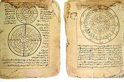
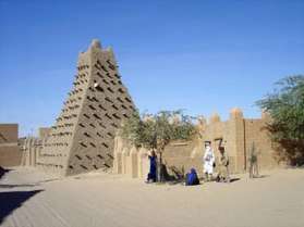
Timbuktu was a world centre of Islamic learning from the 13th to the 17th century, especially under the Mali Empire and Askia Mohammad I's rule. The Malian government and NGOs have been working to catalog and restore the remnants of this scholarly legacy: Timbuktu's manuscripts.[74]
Timbuktu's rapid economic growth in the 13th and 14th centuries drew many scholars from nearby Walata (today in Mauretania),[75] leading up to the city's golden age in the 15th and 16th centuries that proved fertile ground for scholarship of religions, arts and sciences. To the people of Timbuktu, literacy and books were symbols of wealth, power, and blessings and the acquisition of books became a primary concern for scholars.[76] An active trade in books between Timbuktu and other parts of the Islamic world and emperor Askia Mohammed's strong support led to the writing of thousands of manuscripts.[77]
Knowledge was gathered in a manner similar to the early, informal European Medieval university model.[75] Lecturing was presented through a range of informal institutions called madrasahs.[78] Nowadays known as the University of Timbuktu, three madrasahs facilitated 25,000 students: Djinguereber, Sidi Yahya and Sankore.[79]
These institutions were explicitly religious, as opposed to the more secular curricula of modern European universities and more similar to the medieval Europe model. However, where universities in the European sense started as associations of students and teachers, West-African education was patronized by families or lineages, with the Aqit and Bunu al-Qadi al-Hajj families being two of the most prominent in Timbuktu – these families also facilitated students is set-aside rooms in their housings.[80] Although the basis of Islamic law and its teaching were brought to Timbuktu from North Africa with the spread of Islam, Western African scholarship developed: Ahmad Baba al Massufi is regarded as the city's greatest scholar.[81]
Timbuktu served in this process as a distribution centre of scholars and scholarship. Its reliance on trade meant intensive movement of scholars between the city and its extensive network of trade partners. In 1468–1469 though, many scholars left for Walata when Sunni Ali's Songhay Empire absorbed Timbuktu and again in 1591 with the Moroccan occupation.[75]
This system of education survived until the late 19th century, while the 18th century saw the institution of itinerant Quranic school as a form of universal education, where scholars would travel throughout the region with their students, begging for food part of the day.[74] Islamic education came under pressure after the French occupation, droughts in the 70s and 80s and by Mali's civil war in the early 90s.[74]
Manuscripts and libraries
Hundreds of thousands of manuscripts were collected in Timbuktu over the course of centuries: some were written in the town itself, others – including exclusive copies of the Quran for wealthy families – imported through the lively booktrade.
Hidden in cellars or buried, hid between the mosque's mud walls and safeguarded by their patrons, many of these manuscripts survived the city's decline. They now form the collection of several libraries in Timbuktu, holding up to 700,000 manuscripts:[82] In late January 2013 it was reported that rebel forces destroyed many of the manuscripts before leaving the city.[83][84] "On Friday morning, January 25, 2013, fifteen jihadis entered the restoration and conservation rooms on the ground floor of the Ahmed Baba Institute in Sankoré...The men swept 4,202 manuscripts off lab tables and shelves, and carried them into the tiled courtyard...They doused the manuscripts in gasoline...and tossed in a lit match. The brittle pages and their dry leather covers...were consumed by the inferno."[85] However, there was no malicious destruction of any library or collection as most of the manuscripts were safely hidden away.[86][87][88][89] One librarian in particular, Abdel Kader Haidara, organized to have 350,000 medieval manuscripts smuggled out of Timbuktu for safekeeping.[90][91]
- Ahmed Baba Institute
- Mamma Haidara Library
- Fondo Kati
- Al-Wangari Library
- Mohamed Tahar Library
- Maigala Library
- Boularaf Collection
- Al Kounti Collections

These libraries are the largest among up to 60 private or public libraries that are estimated to exist in Timbuktu today, although some comprise little more than a row of books on a shelf or a bookchest.[92] Under these circumstances, the manuscripts are vulnerable to damage and theft, as well as long term climate damage, despite Timbuktu's arid climate. Two Timbuktu Manuscripts Projects funded by independent universities have aimed to preserve them.
During the occupation by Islamic extremists the citizens of the city embarked on a drive to save the "best written accounts of African History." Interviewed by the Times the local residents claimed to have safeguarded the three hundred thousand manuscripts for generations. Many of these documents are still in the safe keeping of the local residents who are reluctant to give them overs to the government-run Ahmed Baba Institute housed in a modern digitalization building built by the South African government in 2009. The institute houses only 10% of the manuscripts[93] It was later confirmed by Jean-Michel Djian to the New Yorker that "the great majority of the manuscripts, about fifty thousand, are actually housed in the thirty-two family libraries of the 'City of 333 Saints'". He added, "Those are to this day protected." He also added that due to the massive efforts of one individual two hundred thousand other manuscripts were successfully transported to safety[94] This effort was organized by Abdel Kader Haidara, then director of Mamma Haidara Library, using his own funds. Haidara purchased metal footlockers in which up to 300 manuscripts could be securely stored. Nearly 2,500 of these lockers were distributed to safe houses across the city. Many were later moved to Dreazen.[95]
Language
Although French is Mali's official language, today the large majority of Timbuktu's inhabitants speaks Koyra Chiini, a Songhay language that also functions as the lingua franca. Before the 1990–1994 Tuareg rebellion, both Hassaniya Arabic and Tamashek were represented by 10% each to an 80% dominance of the Koyra Chiini language. With Tamashek spoken by both Ikelan and ethnic Tuaregs, its use declined with the expulsion of many Tuaregs following the rebellion, increasing the dominance of Koyra Chiini.[96]
Arabic, introduced together with Islam during the 11th century, has mainly been the language of scholars and religion, comparable to Latin in Western Christianity.[97] Although Bambara is spoken by the most numerous ethnic group in Mali, the Bambara people, it is mainly confined to the south of the country. With an improving infrastructure granting Timbuktu access to larger cities in Mali's South, use of Bambara was increasing in the city at least until Azawad independence.[96]
Infrastructure
With no railroads in Mali except for the Dakar-Niger Railway up to Koulikoro, access to Timbuktu is by road, boat or, since 1961, aircraft.[98] With high water levels in the Niger from August to December, Compagnie Malienne de Navigation (COMANAV) passenger ferries operate a leg between Koulikoro and downstream Gao on a roughly weekly basis. Also requiring high water are pinasses (large motorized pirogues), either chartered or public, that travel up and down the river.[99]
Both ferries and pinasses arrive at Korioumé, Timbuktu's port, which is linked to the city centre by an 18 km (11 mi) paved road running through Kabara. In 2007, access to Timbuktu's traditional port, Kabara, was restored by a Libyan funded project that dredged the 3 km (2 mi) silted canal connecting Kabara to an arm of the Niger River. COMANAV ferries and pinassses are now able to reach the port when the river is in full flood.[14][100]
Timbuktu is poorly connected to the Malian road network with only dirt roads to the neighbouring towns. Although the Niger River can be crossed by ferry at Korioumé, the roads south of the river are no better. However, a new paved road is under construction between Niono and Timbuktu running to the north of the Inland Niger Delta. The 565 km (351 mi) road will pass through Nampala, Léré, Niafunké, Tonka, Diré and Goundam.[101][102] The completed 81 km (50 mi) section between Niono and the small village of Goma Coura was financed by the Millennium Challenge Corporation.[103] This new section will service the Alatona irrigation system development of the Office du Niger.[104] The 484 km (301 mi) section between Goma Coura and Timbuktu is being financed by the European Development Fund.[101]
Timbuktu Airport is served by Air Mali, hosting flights to and from Bamako, Gao and Mopti.[99] Its 6,923 ft (2,110 m) runway in a 07/25 runway orientation is both lighted and paved.[105]
In popular culture
In the imagination of Europeans and North Americans, Timbuktu is a place that bears with it a sense of mystery: a 2006 survey of 150 young Britons found 34% did not believe the town existed, while the other 66% considered it "a mythical place".[106] This sense has been acknowledged in literature describing African history and African-European relations. Timbuktu is also often considered a far away place, in popular Western culture.[2][107][108]
The origin of this mystification lies in the excitement brought to Europe by the legendary tales, especially those by Leo Africanus: Arabic sources focused mainly on more affluent cities in the Timbuktu region, such as Gao and Walata.[9] In West Africa the city holds an image that has been compared to Europe's view on Athens.[107] As such, the picture of the city as the epitome of distance and mystery is a European one.[2]
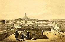
Down-to-earth-aspects in Africanus' descriptions were largely ignored and stories of great riches served as a catalyst for travellers to visit the inaccessible city – with prominent French explorer René Caillié characterising Timbuktu as "a mass of ill-looking houses built of earth".[109] Now opened up, many travellers acknowledged the unfitting description of an "African El Dorado".[24] This development shifted the city's reputation – from being fabled because of its gold to fabled because of its location and mystery. Being used in this sense since at least 1863, English dictionaries now cite Timbuktu as a metaphor for any faraway place.[110]
Twin towns – sister cities
Timbuktu is a sister city to the following cities:[111]
- Chemnitz, Germany
- Hay-on-Wye, Wales, United Kingdom
- Kairuan, Tunisia
- Marrakech, Morocco
- Saintes, France
- Tempe, Arizona, United States
References
- Resultats Provisoires RGPH 2009 (Région de Tombouctou) (PDF), République de Mali: Institut National de la Statistique
- "Timbuktu" – regardless of spelling, has long been used as a metaphor for "out in the middle of nowhere". E.g. "From here to Timbuktu and back." Pelizzo, Riccardo (2001). "Timbuktu: A Lesson in Underdevelopment" (PDF). Journal of World-Systems Research. 7 (2): 265–283. doi:10.5195/JWSR.2001.166. Archived from the original (PDF) on 18 July 2010. Retrieved 25 March 2010.
- Leo Africanus 1896, p. 824 Vol. 3.
- Barth 1857, p. 284 footnote Vol. 3.
- Cissoko, S.M (1996). l'Empire Songhai. Paris: L'Harmattan.
- Hunwick 2003, p. 29.
- Hunwick 2003, p. 29 note 4.
- Insoll 2002, p. 9.
- Insoll 2004.
- Insoll 2002.
- McIntosh & McIntosh 1986.
- Park 2010.
- Park 2011.
- Développement régional: le fleuve est de rétour à Tombouctou, Présidence de la République du Mali, 3 December 2007, archived from the original on 1 October 2011, retrieved 19 March 2011
- Composite Runoff Fields V 1.0: Koulikoro, University of New Hampshire/Global Runoff Data Center, retrieved 30 January 2011
- Composite Runoff Fields V 1.0: Diré, University of New Hampshire/Global Runoff Data Center, retrieved 30 January 2011. Diré is the nearest hydrometric station on the River Niger, 70 km (43 mi) upstream of Timbuktu.
- Hacquard 1900, p. 12.
- Barth 1857, Vol. 3, p. 324.
- Dubois 1896, p. 196.
- Jones, Jim (1999), Rapports Économiques du Cercle de Tombouctou, 1922–1945: Archives Nationales du Mali, Fonds Recents (Series 1Q362), West Chester University, Pennsylvania, retrieved 26 March 2011
- Lancement des travaux du Canal de Tombouctou : la mamelle nourricière redonne vie et espoir à la 'Cité mystérieuse', Afribone, 14 August 2006
- Coulibaly, Be (12 January 2011), Canal de Daye à Tombouctou: la sécurité des riverains, Primature: République du Mali, archived from the original on 24 July 2011, retrieved 26 March 2011
- Adefolalu, D.O. (25 December 1984). "On bioclimatological aspects of Harmattan dust haze in Nigeria". Meteorology and Atmospheric Physics. 33 (4): 387–404. Bibcode:1984AMGBB..33..387A. doi:10.1007/BF02274004.
- Benjaminsen, Tor A; Berge, Gunnvor (2004). "Myths of Timbuktu: From African El Dorado to Desertification". International Journal of Political Economy. 34 (1): 31–59. doi:10.1080/08911916.2004.11042915. Retrieved 14 September 2010.
- "World Weather Information Service – Tombouctou (1950–2000)". World Meteorological Organization. Retrieved 14 February 2011.
- "Tomb (Tombouctou) Climate Normals 1961–1990". National Oceanic and Atmospheric Administration. Retrieved 12 October 2015.
- "Station Tombouctou" (in French). Meteo Climat. Retrieved 10 June 2016.
- Miner 1953, p. 68 n27.
- Meunier, D. (1980), "Le commerce du sel de Taoudeni", Journal des Africanistes (in French), 50 (2): 133–144, doi:10.3406/jafr.1980.2010
- Harding, Andrew (3 December 2009), Timbuktu's ancient salt caravans under threat, BBC News, retrieved 6 March 2011
- Maynes, Mary Jo; Waltner, Ann (2012). The Family: A World History. New York: Oxford University Press, Inc. p. 45. ISBN 9780195338140.
- Thom, Derrick J.; Wells, John C. (1987), "Farming Systems in the Niger Inland Delta, Mali", Geographical Review, 77 (3): 328–342, doi:10.2307/214124, JSTOR 214124
- Schéma Directeur d'Urbanisme de la Ville de Tombouctou et Environs (PDF) (in French), Bamako, Mali: Ministère de l'Habitat et de l'Urbanisme, République du Mali, 2006, archived from the original (PDF) on 28 April 2011
- Synthèse des Plan de Securité Alimentaire des Communes du Circle de Tombouctou 2006–2010 (PDF) (in French), Commissariat à la Sécurité Alimentaire, République du Mali, USAID-Mali, 2006, archived from the original (PDF) on 6 September 2011, retrieved 2 May 2011
- Styger, Erika (2010), Introducing the System of Rice Intensification (SRI) to irrigated systems in Gao, Mopti, Timbuktu and to rainfed systems in Sikasso (PDF), Bamako, Mali: USAID, Initiatives Intégrées pour la Croissance Économique au Mali, Abt Associates
- https://www.tripadvisor.com/Hotel_Review-g304007-d599260-Reviews-Hotel_Hendrina_Khan-Timbuktu_Tombouctou_Region.html
- Sayah, Moulaye (3 October 2011), Tombouctou : le tourisme en desherence (in French), L'Essor, retrieved 28 November 2011
- Travelling and living abroad: Sahel, United Kingdom Foreign and Commonwealth Office, retrieved 1 January 2012
- "Mali says Tuareg rebels abduct group of tourists". Reuters. 22 January 2009. Retrieved 1 January 2012.
- Al-Qaeda 'kills British hostage', BBC News, 3 June 2009, retrieved 1 January 2012
- Mali: Securite (in French), Ministère des affaires étrangères et européennes, retrieved 28 November 2011
- Mali travel advice, United Kingdom Foreign and Commonwealth Office, archived from the original on 4 October 2009, retrieved 28 November 2011
- Travel Warning US Department of State, Bureau of Consular Affairs: Mali, US Department of State, 4 October 2011, archived from the original on 26 November 2011, retrieved 28 November 2011
- Togola, Diakaridia (11 January 2010), Festival sur le désert : Essakane a vibré au rythme de la 10ème édition (in French), Le Quotidien de Bamako, archived from the original on 15 April 2012, retrieved 25 December 2011
- Tombouctou: Le Festival du Désert aura bien lieu (in French), Primature: Portail Officiel du Gouvernement Mali, 28 October 2010, archived from the original on 24 September 2015, retrieved 25 December 2011
- "Mali kidnapping: One dead and three seized in Timbuktu". BBC News. 25 November 2011. Retrieved 28 November 2011.
- Sayad, Moulaye (28 November 2011), Tombouctou : Sous le Choc (in French), L'Essor, retrieved 1 January 2012
- Callimachi, Rukmini (1 April 2012), "Mali coup leader reinstates old constitution", The Atlanta Journal-Constitution, Associated Press, retrieved 31 March 2012
- Tuareg rebels declare the independence of Azawad, north of Mali, Al Arabiya, 6 April 2012, retrieved 6 April 2012
- Moseley, Walter G. (18 April 2012), Azawad: the latest African Border Dilemma, Al Jazeera
- Diarra, Adam (28 January 2013), French seal off Mali's Timbuktu, rebels torch library, Reuters
- Shamil, Jeppie (29 January 2013). "Timbuktu Manuscripts Project". BBC News. Retrieved 29 January 2013. Also broadcast BBC World Service news on 29 January 2013.
- Staff (28 January 2013). "Mali – Islamists Rebels Burn Manuscript Library as They Leave Timbuktu". Reuters (via Africa – News and Analysis). Retrieved 31 January 2013.
- Leo Africanus 1896.
- Brians, Paul (1998). Reading About the World. Fort Worth, TX, USA: Harcourt Brace College Publishing. pp. vol. II.
- Jackson 1820, p. 10.
- Jackson 1820.
- A paper from 1995 says this was "apparently one of the Maraka towns". A book of letters to Thomas Jefferson mentions in connexion to a letter of 1798 that explorer Mungo Park had tried unsuccessfully to find Housa and Timbuktu (1795–7). In a later expedition he went near Timbuktu while descending the Niger River. After being attacked many times by Africans he drowned in the river.
- Reiser, Melissa Diane (2007). Festival au Desert, Essakane, Mali: a postcolonial, postwar Tuareg experiment. Madison: University of Wisconsin – Madison.
- Jeppie 2008.
- Hammer, Joshua (2016). The Bad-Ass Librarians of Timbuktu And Their Race to Save the World's Most Precious Manuscripts. 1230 Avenue of the Americas New York, NY 10020: Simon & Schuster. p. 133. ISBN 978-1-4767-7743-6.CS1 maint: location (link)
- Hammer, Joshua (2016). The Bad-Ass Librarians of Timbuktu And Their Race to Save the World's Most Precious Manuscripts. 1230 Avenue of the Americas New York, NY 10020: Simon & Schuster. p. 228. ISBN 978-1-4767-7743-6.CS1 maint: location (link)
- "Report of the World Heritage Committee Twelfth Session", Convention Concerning the Protection of the World Cultural and Natural Heritage, Brasilia: UNESCO, 1988
- ICOMOS (14 May 1979). "Advisory Body Evaluation of Timbuktu Nomination" (PDF). UNESCO. Retrieved 22 February 2011.
- Mali Government (14 May 1979). "Nomination No. 119" (PDF). Convention Concerning the Protection of the World Cultural and Natural Heritage. UNESCO. Retrieved 22 February 2011.
- Amelan, Roni (13 July 2005). "Three Sites Withdrawn from UNESCO's List of World Heritage in Danger". World Heritage Convention News & Events. UNESCO. Retrieved 22 February 2011.
- "WHC Requests Close Surveillance of Bordeaux, Machu Picchu, Timbuktu and Samarkand". World Heritage Convention News & Events. UNESCO. 10 July 2008. Retrieved 22 February 2011.
- Decision 33COM 7B.45 – Timbuktu (Mali), Final Decisions of the 33rd Session of the WHC, Seville, 2009
- "Timbuktu shrines damaged by Mali Ansar Dine Islamists". BBC News. 30 June 2012. Retrieved 1 July 2012.
- "Mali Islamist militants 'destroy' Timbuktu saint's tomb". BBC News. 6 May 2012. Retrieved 1 July 2012.
- Al Jazeera (1 June 2012). Ansar Dine fighters destroy Timbuktu shrines. Retrieved 1 July 2012
- Guled Yusuf and Lucas Bento, The New York Times (31 July 2012). The 'End Times' for Timbuktu? Retrieved 31 July 2012
- UNESCO World Heritage Centre. "UNESCO World Heritage Centre – Creation of a Special Fund for the Safeguarding of Mali's World Heritage sites". Whc.unesco.org. Retrieved 16 May 2014.
- Huddleston, Alexandra (1 September 2009). "Divine Learning: The Traditional Islamic Scholarship of Timbuktu". Fourth Genre: Explorations in Non-Fiction. 11 (2): 129–135. doi:10.1353/fge.0.0080. ISSN 1522-3868.
- Cleaveland 2008.
- Singleton, Brent D. (2004). "African Bibliophiles: Books and Libraries in Medieval Timbuktu". Libraries & Culture. 39 (1): 1–12. doi:10.1353/lac.2004.0019. JSTOR 25549150.
- Medupe, Rodney Thebe; Warner, Brian; Jeppie, Shamil; Sanogo, Salikou; Maiga, Mohammed; Maiga, Ahmed; Dembele, Mamadou; Diakite, Drissa; Tembely, Laya; Kanoute, Mamadou; Traore, Sibiri; Sodio, Bernard; Hawkes, Sharron (2008). "The Timbuktu Astronomy Project". In Holbrook, Jarita; Medupe, R. Thebe; Urama, Johnson O. (eds.). African Cultural Astronomy. Astrophysics and Space Science Proceedings. p. 179. doi:10.1007/978-1-4020-6639-9_13. ISBN 9781402066399.
- Makdisi, George (April–June 1989), "Scholasticism and Humanism in Classical Islam and the Christian West", Journal of the American Oriental Society, 109 (2): 175–182 [176], doi:10.2307/604423, JSTOR 604423
- University of Timbuktu, Mali Archived 24 September 2012 at the Wayback Machine – Timbuktu Educational Foundation
- Hunwick 2003, pp. lvii.
- Polgreen, Lydia (7 August 2007). "Timbuktu Hopes Ancient Texts Spark a Revival". The New York Times. Retrieved 4 March 2011.
- Rainier, Chris (27 May 2003). "Reclaiming the Ancient Manuscripts of Timbuktu". National Geographic News. Retrieved 13 July 2010.
- Harding, Luke (28 January 2013), Timbuktu mayor: Mali rebels torched library of historic manuscripts, London: The Guardian, retrieved 27 February 2013
- Diarra, Adama (28 January 2013), French, Malians retake Timbuktu, rebels torch library, Reuters, retrieved 27 February 2013
- Hammer, Joshua (2016). The Bad-Ass Librarians of Timbuktu And Their Race to Save the World's Most Precious Manuscripts. 1230 Avenue of the Americas: Simon & Schuster. pp. 235–6. ISBN 978-1-4767-7743-6.CS1 maint: location (link)
- Timbuktu update, Tombouctou Manuscripts Project, University of Cape Town, 30 January 2013, retrieved 27 February 2013
- Zanganeh, Lila Azam (29 January 2013), Has the great library of Timbuktu been lost?, The New Yorker, retrieved 27 February 2013
- Precious history in Timbuktu library saved from fire, The History Blog, retrieved 27 February 2013
- Hinshaw, Drew (1 February 2013), Historic Timbuktu Texts Saved From Burning, The Wall Street Journal, retrieved 27 February 2013
- "Timbuktu's 'Badass Librarians': Checking Out Books Under Al-Qaida's Nose". NPR.org.
- Hammer, J. (2016) "The Bad-Ass Librarians of Timbuktu." Simon and Schuster.
- Grant, Simon (8 February 2007), "Beyond the Saharan Fringe", The Guardian, London, retrieved 19 July 2010
- Walt, Vivienne. "Timbuktu's Ancient Libraries: Saved by Locals, Endangered by a Government". Time. ISSN 0040-781X. Retrieved 23 April 2018.
- Zanganeh, Lila Azam (29 January 2013). "Has the Great Library of Timbuktu Been Lost?". The New Yorker. ISSN 0028-792X. Retrieved 23 April 2018.
- Commisso, Corrie (1 May 2015). "The Literary Refugees of Timbuktu: How a Group of Unlikely Allies Thwarted Al Qaeda and Organized One of the Most Brazen Cultural Heritage Evacuations Ever Attempted". Preservation, Digital Technology & Culture. 44 (2).
- Heath 1999, pp. 4–5.
- Forma, Aminatta (7 February 2009). "The Lost Libraries of Timbuktu". The Sunday Times. London, UK. Retrieved 15 February 2011.
- Rosberg, Carl Gustav (1964), Political Parties and National Integration in Tropical Africa, Berkeley, CA: University of California Press, p. 222, ISBN 9780520002531
- Pitcher, Gemma (2007). Africa. Melbourne: Lonely Planet Guides. pp. 403–418. ISBN 9781741044829.
timbuktu lonely planet.
- Lancement des travaux du Canal de Tombouctou : la mamelle nourricière redonne vie et espoir à la 'Cité mystérieuse', Afribone, 14 August 2006
- Coulibaly, Baye (24 November 2010), Route Tombouctou-Goma Coura: un nouveau chantier titanesque est ouvert, L'Essor, retrieved 19 March 2011
- Coulibaly, Baye (19 January 2012), Route Tombouctou-Goma Coura: le chantier advance à grand pas, L'Essor, retrieved 1 May 2012
- Niono-Goma Coura Road Inauguration, Embassy of the United States, Mali, 7 February 2009, archived from the original on 14 May 2011, retrieved 19 March 2011
- Mali Compact (PDF), Millennium Challenge Corporation, 17 November 2006, archived from the original (PDF) on 25 March 2012
- Pilot Information for Timbuktu Airport, Megginson Technologies, 2010, retrieved 18 February 2011
- Search on for Timbuktu's twin, BBC News, 18 October 2006, retrieved 22 November 2010
- Saad 1983.
- Barrows, David Prescott (1927). Berbers and Blacks: Impressions of Morocco, Timbuktu and the Western Sudan. Whitefish, Montana: Kessinger Publishing. p. 10.
- Caillié 1830, p. 49 Vol. 2.
- "Entry on 'Timbuktu'". Online Etymology Dictionary. Douglas Harper. 2002. Retrieved 17 September 2010.
- "Timbuktu 'twins' make first visit". BBC News. 24 October 2007. Retrieved 24 May 2010.
Sources
- Barth, Heinrich (1857), Travels and discoveries in North and Central Africa: Being a journal of an expedition undertaken under the auspices of H. B. M.'s government, in the years 1849–1855. (3 Vols), New York: Harper & Brothers. Google books: Volume 1, Volume 2, Volume 3.
- Caillié, Réné (1830), Travels through Central Africa to Timbuctoo; and across the Great Desert, to Morocco, performed in the years 1824–1828 (2 Vols), London: Colburn & Bentley. Google books: Volume 1, Volume 2.
- Cleaveland, Timothy (2008), "Timbuktu and Walata: lineages and higher education", in Jeppie, Shamil; Diagne, Souleymane Bachir (eds.), The Meanings of Timbuktu (PDF), Cape Town: HSRC Press, pp. 77–91, ISBN 978-0-7969-2204-5.
- Dubois, Felix (1896), Timbuctoo the mysterious, White, Diana (trans.), New York: Longmans.
- Hacquard, Augustin (1900), Monographie de Tombouctou, Paris: Société des études coloniales & maritimes. Also available from Gallica.
- Heath, Jeffrey (1999), A Grammar of Koyra Chiini: the Songhay of Timbuktu, Berlin: Walter de Gruyter, ISBN 9783110162851.
- Hunwick, John O. (2003), Timbuktu and the Songhay Empire: Al-Sadi's Tarikh al-Sudan down to 1613 and other contemporary documents, Leiden: Brill, ISBN 978-90-04-12560-5. First published in 1999 as ISBN 90-04-11207-3.
- Insoll, Timothy (2002), "The Archaeology of Post Medieval Timbuktu" (PDF), Sahara, 13: 7–22, archived from the original (PDF) on 8 March 2012.
- Insoll, Timothy (2004), "Timbuktu the less Mysterious?" (PDF), in Mitchell, P.; Haour, A.; Hobart, J. (eds.), Researching Africa's Past. New Contributions from British Archaeologists, Oxford: Oxbow, pp. 81–88.
- Jackson, James Grey (1820), An Account of Timbuctoo and Housa, Territories in the Interior of Africa By El Hage Abd Salam Shabeeny, London: Longman, Hurst, Rees, Orme, and Brown.
- Jeppie, Shamil (2008), "Re/discovering Timbuktu", in Jeppie, Shamil; Diagne, Souleymane Bachir (eds.), The Meanings of Timbuktu (PDF), Cape Town: HSRC Press, pp. 1–17, ISBN 978-0-7969-2204-5.
- Leo Africanus (1896), The History and Description of Africa (3 Vols), Brown, Robert, editor, London: Hakluyt Society. A facsimile of Pory's English translation of 1600 together with an introduction and notes by the editor. Internet Archive: Volume 1, Volume 2, Volume 3
- McIntosh, Susan Keech; McIntosh, Roderick J. (1986), "Archaeological reconnaissance in the region of Timbuktu", National Geographic Research, 2: 302–319.
- Miner, Horace (1953), The primitive city of Timbuctoo, Princeton University Press. Link requires subscription to Aluka. Reissued by Anchor Books, New York in 1965.
- Park, Douglas (2010), "Timbuktu and its prehistoric hinterland", Antiquity, 84 (326): 1076–1088, doi:10.1017/S0003598X00067090.
- Park, Douglas (2011), Climate Change, Human Response and the Origins of Urbanism at Prehistoric Timbuktu, New Haven: PhD thesis, Yale University, Department of Anthropology.
- Saad, Elias N. (1983), Social History of Timbuktu: The Role of Muslim Scholars and Notables 1400–1900, Cambridge University Press, ISBN 978-0-521-24603-3.
External links
| Wikimedia Commons has media related to Timbuktu. |
| Wikivoyage has a travel guide for Timbuktu. |
| Wikiquote has quotations related to: Timbuktu |
- Timbuktu – Ancient History Encyclopedia
- . Encyclopædia Britannica. 26 (11th ed.). 1911.
- Jeppie, Ahamil "A Timbuktu book collector between the Mediterranean and Sahel", Video of a presentation given at the conference The southern shores of the Mediterranean and beyond: 1800 – to the present held at the University of Minnesota in April 2013.
- – contains information on the archaeological projects targeting the Iron Age occupation of Timbuktu
- Ancient West Africa's Megacities – contains video footage of Timbuktu's Iron Age occupation
- Islamic Manuscripts from Mali, Library of Congress – fuller presentation of the same manuscripts from the Mamma Haidara Commemorative Library
- Timbuktu materials in the Aluka digital library
- Timbuktu manuscripts: Africa's written history unveiled, The UNESCO Courier, 2007-5, pp. 7–9
- Ancient chroniclers of West Africa's past; journeys of discovery through the 'country of the black people', The UNESCO Courier, October 1959
- Timbuktu on Global Heritage Network – early warning and threat monitoring system for endangered cultural heritage sites
- Presentation showing images of Timbuktu
- ArchNet.org. "Timbuctu". Cambridge, Massachusetts, USA: MIT School of Architecture and Planning. Archived from the original on 14 April 2013.
| Countries |  | |
|---|---|---|
| Sections |
| |
| Tributaries (list) and distributaries |
| |
| Cities | ||
| Lakes | ||
| Dams and bridges |
| |
| Protected Areas | ||
Capital: Timbuktu | ||
| Diré Cercle |
|  |
| Goundam Cercle |
| |
| Gourma-Rharous Cercle | ||
| Niafunké Cercle | ||
| Timbuktu Cercle |
| |