Otelfingen
Otelfingen is a municipality in the district of Dielsdorf in the canton of Zürich in Switzerland.
Otelfingen | |
|---|---|
 | |
 Coat of arms | |
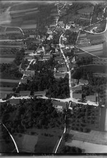
Location of Otelfingen 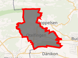
| |
 Otelfingen Otelfingen | |
| Coordinates: 47°28′N 8°23′E | |
| Country | Switzerland |
| Canton | Zurich |
| District | Dielsdorf |
| Area | |
| • Total | 7.23 km2 (2.79 sq mi) |
| Elevation | 440 m (1,440 ft) |
| Population (2018-12-31)[2] | |
| • Total | 2,939 |
| • Density | 410/km2 (1,100/sq mi) |
| Postal code | 8112 |
| SFOS number | 0094 |
| Surrounded by | Boppelsen, Buchs, Dänikon, Hüttikon, Niederweningen, Schleinikon, Wettingen (AG), Würenlos (AG) |
| Website | www SFSO statistics |
History
Otelfingen is first mentioned in 1044 as Otilingun though there is some debate about this identification. In 1079 it was mentioned as Notkerus de Otelfingen.[3]
Geography
Otelfingen has an area of 7.2 km2 (2.8 sq mi). Of this area, 47.1% is used for agricultural purposes, while 37.1% is forested. Of the rest of the land, 14.8% is settled (buildings or roads) and the remainder (1%) is non-productive (rivers, glaciers or mountains).[4]
The majority of the municipality is the village of Otelfingen, a Haufendorf (an irregular, unplanned and quite closely packed village, built around a central square) located in the Furttal on the border with the Canton of Aargau.
Demographics
Otelfingen has a population (as of 31 December 2018) of 2,939.[5] As of 2007, 16.2% of the population was made up of foreign nationals. Over the last 10 years the population has grown at a rate of 33.6%. Most of the population (as of 2000) speaks German (91.7%), with Italian being second most common ( 3.0%) and French being third ( 1.1%).
In the 2007 election the most popular party was the SVP which received 41.9% of the vote. The next three most popular parties were the SPS (15.9%), the FDP (12.6%) and the CSP (10.8%).
The age distribution of the population (as of 2000) is children and teenagers (0–19 years old) make up 24.6% of the population, while adults (20–64 years old) make up 65.4% and seniors (over 64 years old) make up 10%. In Otelfingen about 80.7% of the population (between age 25-64) have completed either non-mandatory upper secondary education or additional higher education (either university or a Fachhochschule).
Otelfingen has an unemployment rate of 2.51%. As of 2005, there were 61 people employed in the primary economic sector and about 17 businesses involved in this sector. 381 people are employed in the secondary sector and there are 44 businesses in this sector. 1677 people are employed in the tertiary sector, with 103 businesses in this sector.[4]
| Historical population | ||||||||||||||||||||||||||||
|---|---|---|---|---|---|---|---|---|---|---|---|---|---|---|---|---|---|---|---|---|---|---|---|---|---|---|---|---|
|
| |||||||||||||||||||||||||||
| Source: [3] | ||||||||||||||||||||||||||||
Weather
Otelfingen has an average of 132.5 days of rain per year and on average receives 1,091 mm (43.0 in) of precipitation. The wettest month is June during which time Otelfingen receives an average of 116 mm (4.6 in) of precipitation. During the wettest month, there is precipitation for an average of 12.7 days. The driest month of the year is October, during which time the municipality receives an average of 72 mm (2.8 in). There are only 8.2 days of precipitation during this month.[6]
Transportation
Otelfingen railway station and Otelfingen Golfpark railway station are stops of the S-Bahn Zürich on the line S6.
References
- "Arealstatistik Standard - Gemeinden nach 4 Hauptbereichen". Federal Statistical Office. Retrieved 13 January 2019.
- "Ständige Wohnbevölkerung nach Staatsangehörigkeitskategorie Geschlecht und Gemeinde; Provisorische Jahresergebnisse; 2018". Federal Statistical Office. 9 April 2019. Retrieved 11 April 2019.
- Otelfingen in German, French and Italian in the online Historical Dictionary of Switzerland.
- Swiss Federal Statistical Office accessed 04-Aug-2009
- Swiss Federal Statistical Office - STAT-TAB, online database – Ständige und nichtständige Wohnbevölkerung nach institutionellen Gliederungen, Geburtsort und Staatsangehörigkeit (in German) accessed 23 September 2019
- "Temperature and Precipitation Average Values-Table, 1961-1990" (in German, French, and Italian). Federal Office of Meteorology and Climatology MeteoSwiss. Archived from the original on 27 June 2009. Retrieved 8 May 2009. The weather station elevation is 435 meters above sea level.
External links
| Wikimedia Commons has media related to Otelfingen. |
- Official website (in German)
- Unofficial website (in German)
Municipalities in Dielsdorf District, Switzerland | ||
|---|---|---|